
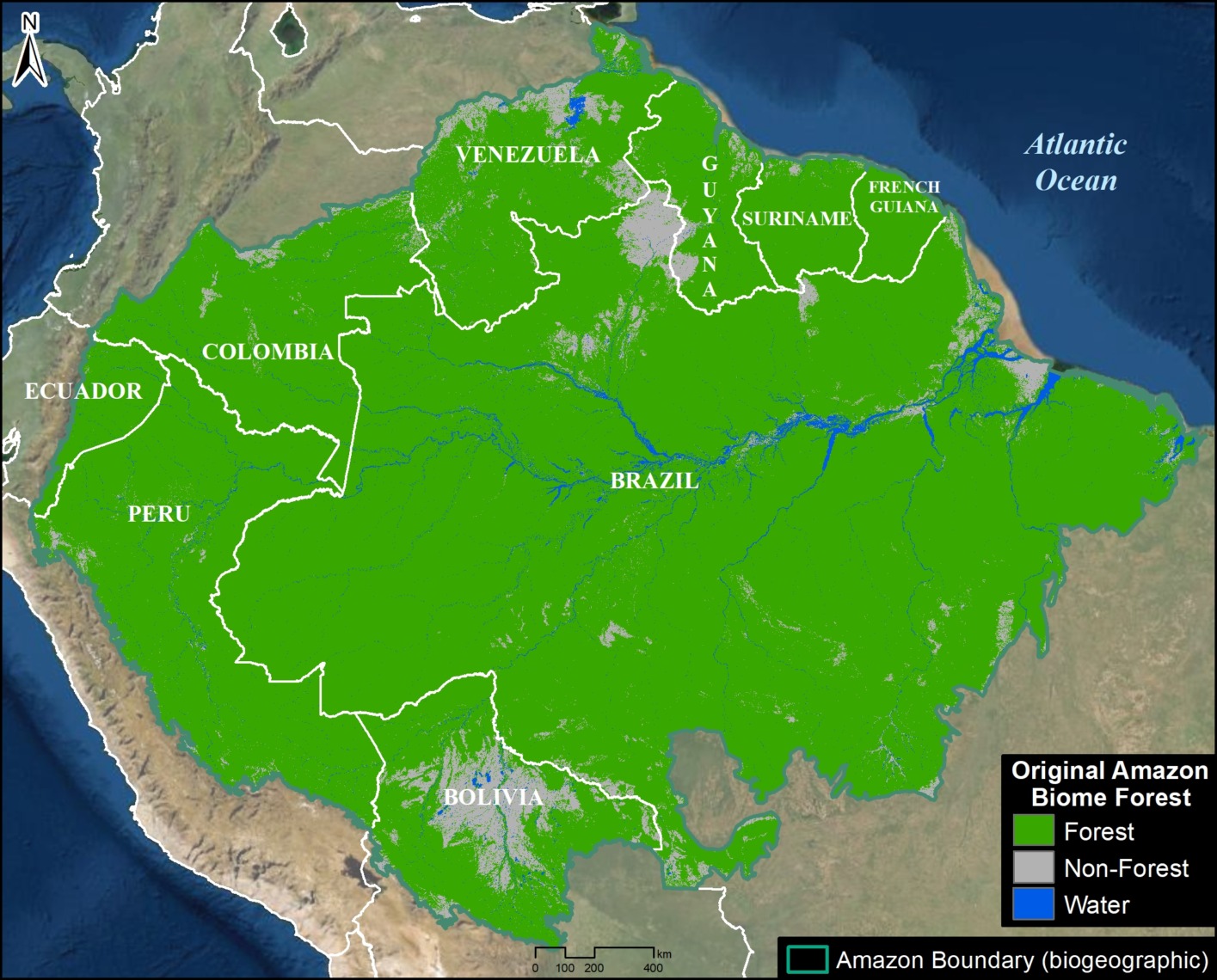
For decades, the question “how big is the Amazon forest?” was answered with a static number: roughly 5.5 million square kilometers. However, in the era of rapid digital transformation, the “size” of the Amazon is no longer a fixed geographic coordinate. Today, determining the scale of the world’s most vital ecosystem is a feat of high-end technology, involving massive data processing, artificial intelligence, and sophisticated remote sensing. As we look at the Amazon through the lens of the tech industry, we see that its magnitude is being redefined by our ability to map it in three dimensions and monitor its pulse in real-time.

The Digital Frontier: Using Remote Sensing to Quantify the Wild
The traditional method of mapping forests involved physical surveys and aerial photography, which were often limited by the sheer density and inhospitability of the Amazon basin. Today, the tech sector has revolutionized this process through remote sensing, allowing us to measure the forest’s extent with unprecedented precision.
Satellite Constellations: The Eyes in the Sky
The primary way we answer how big the Amazon is today is through a network of Earth-observation satellites. Programs like the European Space Agency’s (ESA) Copernicus Sentinel-2 and NASA’s Landsat series provide a constant stream of multi-spectral data. These satellites don’t just take pictures; they capture data across various light frequencies, including infrared, which allows tech platforms to distinguish between healthy forest, degraded land, and agricultural encroachment.
Furthermore, private tech firms like Planet have deployed constellations of “CubeSats”—miniature satellites that capture daily images of the entire Amazon basin. This high-frequency data allows software developers to build change-detection algorithms that can identify a single hectare of forest loss within 24 hours.
LiDAR Technology: Seeing Through the Canopy
To truly understand the “size” of the Amazon, we must look beyond surface area and consider volume. This is where LiDAR (Light Detection and Ranging) comes into play. LiDAR is a remote sensing technology that uses laser pulses to measure distances to the Earth. When mounted on aircraft or specialized drones, LiDAR can penetrate the dense leaf canopy to map the forest floor and the vertical structure of the trees.
By measuring the “height” of the forest, tech companies can calculate biomass. This transition from 2D maps to 3D models has revealed that the Amazon is “bigger” than previously thought in terms of carbon storage capacity. This tech provides a granular view of the forest’s architectural complexity, which is essential for quantifying its true ecological footprint.
AI and Machine Learning: From Pixels to Patterns
The sheer volume of data generated by satellites is too immense for human analysts to process. The tech industry has stepped in with Artificial Intelligence (AI) and Machine Learning (ML) to turn petabytes of imagery into actionable insights.
Deep Learning for Deforestation Detection
Machine learning models are now trained to recognize the distinct patterns of deforestation. Whether it’s the “fishbone” pattern of illegal roads or the clearing of land for cattle ranching, AI algorithms can categorize land use at a scale impossible for manual review. Software platforms like Global Forest Watch utilize these algorithms to alert local authorities and NGOs the moment the forest’s boundaries shift.
These AI models are constantly evolving. By utilizing deep learning, they can now differentiate between natural seasonal changes in the canopy and anthropogenic disturbances. This technological nuance is critical in accurately reporting the current size and health of the Amazon.
Predictive Analytics: Mapping the Future
Beyond measuring how big the Amazon is today, tech tools are being used to predict how big it will be tomorrow. Predictive analytics software takes historical data, climate models, and socio-economic trends to forecast areas at high risk of forest loss. These tools allow conservationists to deploy resources proactively. The integration of “Big Data” into environmental science has transformed the question of size from a retrospective measurement into a forward-looking strategy.
The Data Ecosystem: Managing Petabytes of Bio-Data
To answer the question of the Amazon’s size, one must also look at the massive computational infrastructure required to store and analyze that information. This is where cloud computing and open-source platforms become the backbone of modern conservation.
Cloud Computing and Large-Scale Analysis
Platforms like Google Earth Engine have democratized access to satellite data. Before the rise of cloud-based geospatial processing, a researcher would need a supercomputer and weeks of time to process a single map of the Amazon. Today, a developer can run a script in the cloud and process decades of satellite imagery in minutes.
This shift to the cloud has allowed for the creation of “MapBiomas,” a collaborative network that uses Google’s infrastructure to produce annual land-cover maps of the entire Amazon. By leveraging the power of distributed computing, the tech community has made it possible to track the forest’s size on a year-by-year basis with high resolution.
Open-Source Platforms for Global Monitoring
The “open-source” philosophy of the tech world has been instrumental in keeping the Amazon’s size under public scrutiny. Open-access APIs and data sets ensure that transparency is maintained. When data is siloed, it is easy for stakeholders to misrepresent the scale of forest loss. However, when the data is open, it creates a global “source of truth.” This technological transparency is a powerful tool for holding governments and corporations accountable for their impact on the rainforest.
The Tech-Driven Carbon Economy: Quantifying Value
In the modern financial and tech landscape, the size of the Amazon is increasingly measured by its capacity to offset carbon emissions. This has led to the rise of specialized software designed to verify carbon credits through “Digital MRV” (Measurement, Reporting, and Verification).
Digital Twins of the Rainforest
One of the most exciting trends in tech is the creation of “Digital Twins”—virtual replicas of physical systems. Researchers are currently working on a Digital Twin of the Amazon. By integrating real-time sensor data, satellite imagery, and weather patterns into a virtual model, scientists can simulate the impact of different climate scenarios.
A Digital Twin allows us to “measure” the forest’s resilience. It helps us understand how big the forest needs to be to maintain its own rainfall cycles—a tipping point that, if crossed, could turn the rainforest into a savannah. This is a high-stakes application of simulation software that could determine the survival of the ecosystem.
Blockchain and the Verification of Forest Assets
As the Amazon becomes a central pillar of the global carbon market, verifying the existence and size of protected areas is paramount. Blockchain technology is being explored as a way to create immutable records of forest conservation. By linking satellite data directly to a blockchain, tech platforms can ensure that a “carbon credit” represents a specific, measured area of the Amazon that remains standing.
This use of distributed ledger technology eliminates double-counting and fraud in the carbon markets. It turns the physical size of the forest into a verified digital asset, creating a direct link between the health of the Amazon and global financial tech (FinTech) systems.

Conclusion: The Infinite Map
So, how big is the Amazon forest? From a technological perspective, the answer is dynamic. It is 5.5 million square kilometers of surface area, billions of individual trees captured in 3D by LiDAR, and petabytes of data flowing through cloud servers.
The tech industry has provided us with the tools to see the Amazon not just as a vast green space on a map, but as a complex, living data set. Through the integration of AI, satellite constellations, and cloud computing, we are now able to monitor its boundaries with centimeter-level precision and predict its future with increasing accuracy. As technology continues to evolve, our understanding of the Amazon’s scale will only deepen, moving from simple measurement to a comprehensive, real-time digital understanding of Earth’s most important biological frontier. The size of the Amazon is no longer just a geographical fact; it is a digital testament to our ability to monitor, understand, and hopefully, protect our planet.
aViewFromTheCave is a participant in the Amazon Services LLC Associates Program, an affiliate advertising program designed to provide a means for sites to earn advertising fees by advertising and linking to Amazon.com. Amazon, the Amazon logo, AmazonSupply, and the AmazonSupply logo are trademarks of Amazon.com, Inc. or its affiliates. As an Amazon Associate we earn affiliate commissions from qualifying purchases.