In the rapidly evolving landscape of digital mapping, geospatial intelligence, and location-based services (LBS), understanding the fundamental mechanics of positioning is more critical than ever. Whether you are developing a fleet management application, optimizing logistics for an e-commerce platform, or integrating geofencing features into a mobile app, the concept of absolute location serves as the bedrock of spatial data. At its core, absolute location is the precise, unchangeable coordinates of a specific point on the Earth’s surface, independent of its relationship to other places.
As technology leans further into real-time tracking, augmented reality (AR) navigation, and IoT-driven urban planning, mastering the distinction between absolute and relative positioning is essential for technical professionals and software architects alike.
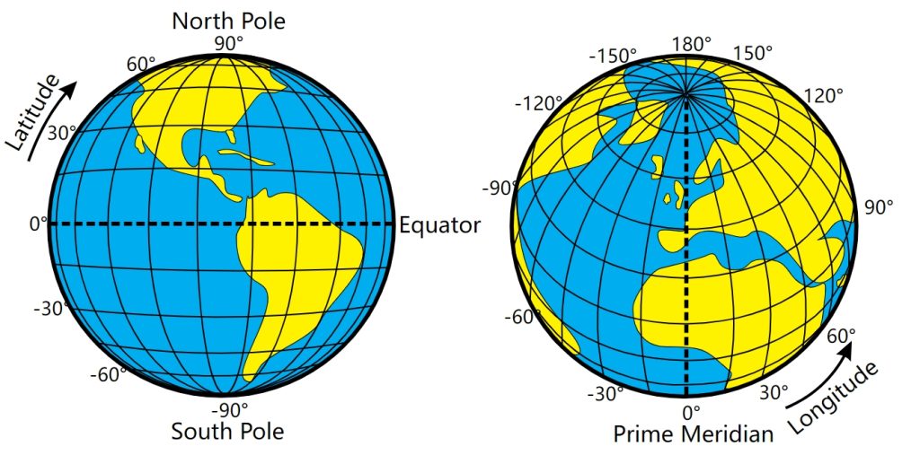
The Technical Foundation: Coordinates and Grids
Absolute location is defined by its objective, immutable nature. Unlike relative location—which describes where a place is in relation to landmarks or other areas (e.g., “three miles north of the city center”)—absolute location uses a standardized mathematical grid. This grid enables computer systems and navigational hardware to “understand” the physical world through numerical data.
The Coordinate Reference System (CRS)
The most common implementation of absolute location is the Latitude and Longitude coordinate system. Latitude measures the distance north or south of the Equator, while Longitude measures the distance east or west of the Prime Meridian. In the context of modern software development, these coordinates are the language of global positioning systems (GPS).
When a developer queries a map API, such as Google Maps or Mapbox, the software translates a specific set of numeric strings—often formatted as decimal degrees—into a pinpoint on a digital canvas. For instance, the absolute location of the Statue of Liberty is approximately 40.6892° N, 74.0445° W. Regardless of how the city around it changes or what new landmarks are built, these coordinates remain the definitive identifier for that specific patch of land.
Datum Standards and Geodesy
Beyond simple coordinates, software engineers must account for the “datum.” Because the Earth is not a perfect sphere, defining an absolute location requires a mathematical model of the planet’s shape, known as a geodetic datum. The World Geodetic System 1984 (WGS 84) is the industry standard for GPS. When building applications, relying on a consistent datum is paramount. Using mismatched datums across disparate datasets can lead to “location drift,” where digital assets appear several meters away from their actual physical coordinates—a catastrophic error for autonomous systems or precision-guided drone software.
Absolute Location in the AI and IoT Ecosystem
In the contemporary tech stack, absolute location is the primary input for AI-driven spatial analysis and IoT sensor arrays. As artificial intelligence models grow more sophisticated, they require high-fidelity absolute data to interpret surroundings, predict movements, and optimize operational workflows.

Enabling Precision in IoT Networks
Consider a smart warehouse environment. Thousands of sensors, automated guided vehicles (AGVs), and robotic arms operate in unison. Each asset’s absolute location is recorded in real-time within the facility’s digital twin. By utilizing Ultra-Wideband (UWB) or high-accuracy GPS, the software ensures that an autonomous forklift knows its absolute position down to the centimeter. This is not about knowing it is “next to the shelves”; it is about knowing its exact X, Y, and Z coordinates within a global framework, preventing collisions and optimizing pick-and-pack routes.
Machine Learning and Spatial Prediction
AI models trained on location data rely on the consistency provided by absolute markers. When an algorithm analyzes traffic patterns, it processes massive datasets where every vehicle’s trajectory is anchored by absolute coordinates. This allows the software to calculate speed, velocity, and deceleration patterns with mathematical certainty. In the realm of digital security and fraud prevention, absolute location is also a key factor. “Impossible travel” algorithms monitor a user’s login attempts by comparing the absolute location of one request to the next. If a user is logged into a web application from Tokyo and then ten minutes later from New York, the system flags the activity, as it is physically impossible to travel between those two absolute points in that timeframe.
Data Interoperability and Geographic Information Systems (GIS)
For software developers working with large-scale data, absolute location is the common denominator that allows different datasets to talk to one another. This interoperability is achieved through Geographic Information Systems (GIS) and standardized data formats like GeoJSON.
GeoJSON and Modern API Integration
In modern web development, developers frequently exchange location data using GeoJSON, a format for encoding a variety of geographic data structures. By structuring data around absolute coordinates, developers can layer different information sets—such as cellular tower locations, climate data, and urban population density—onto a single interface. Because every point of data has a fixed, absolute address on the Earth, software can perform “spatial joins.” This is a process where the system asks, “Which points from Dataset A fall within the boundary of Area B?” Without a standardized understanding of absolute location, these complex queries would be impossible to execute at scale.
The Shift Toward Precision Engineering
As industries migrate toward “Smart Cities,” the requirement for absolute accuracy increases. Software platforms are now integrating Real-Time Kinematic (RTK) positioning to enhance standard GPS. RTK uses a stationary base station to correct errors in the satellite signal, providing absolute location accuracy within a margin of 1 to 2 centimeters. For developers of mobile applications, this level of precision opens doors to hyper-local advertising, augmented reality gaming that interacts perfectly with physical sidewalks, and automated delivery services that can navigate city streets without human intervention.
Challenges and Considerations for Technical Implementation
While absolute location provides a robust framework, it is not without its technical hurdles. Developers must manage factors like signal latency, atmospheric interference, and data density.
Managing Latency in Mobile Apps
For mobile applications relying on absolute location, the “Time to First Fix” (TTFF) is a critical performance metric. This is the time it takes for a receiver to acquire the satellite signals necessary to determine its absolute position. Developers often implement “Assisted GPS” (A-GPS), which uses cellular network data to help the device find satellites faster. This architectural choice is vital for user experience; if a navigation app takes thirty seconds to locate the user’s absolute position upon startup, the churn rate for that application will inevitably rise.

The Security of Location Data
The absolute location of a user is perhaps the most sensitive piece of data in the digital economy. As privacy regulations such as GDPR and CCPA become more stringent, software architects must build “privacy-by-design” into their geolocation features. This includes techniques like “geohashing,” where precise absolute coordinates are rounded off to a larger, less specific grid area before being stored in a database. This maintains the utility of the data for regional analytics while protecting the specific absolute location of individual users.
Ultimately, the definition of absolute location has evolved from a simple mapping concept into a sophisticated technical requirement that powers our digital world. Whether it is through the precise mathematics of coordinate reference systems, the integration of AI in autonomous systems, or the complex data handling required by GIS platforms, absolute location is the language that allows software to navigate, manage, and understand the physical reality we inhabit. For any professional building in the tech space, mastery of this concept is not just an academic exercise—it is the prerequisite for building the next generation of location-aware technology.
aViewFromTheCave is a participant in the Amazon Services LLC Associates Program, an affiliate advertising program designed to provide a means for sites to earn advertising fees by advertising and linking to Amazon.com. Amazon, the Amazon logo, AmazonSupply, and the AmazonSupply logo are trademarks of Amazon.com, Inc. or its affiliates. As an Amazon Associate we earn affiliate commissions from qualifying purchases.