While the term “Special Marine Warning” might evoke images of naval operations or clandestine underwater missions, its true significance lies within the realm of weather forecasting and public safety. This isn’t a term confined to military jargon; rather, it’s a critical communication tool issued by meteorological agencies to alert mariners of immediate and potentially dangerous weather conditions over specific waterways. Understanding what a Special Marine Warning entails is paramount for anyone operating a vessel, from recreational boaters to commercial fishermen and cargo ship captains, as it directly impacts safety, operational planning, and ultimately, the preservation of life and property.

The National Weather Service (NWS) in the United States is the primary issuer of these warnings, alongside similar agencies in other countries. Their purpose is to convey a clear and urgent message about hazardous weather that poses a significant and imminent threat to the marine community. Unlike broader weather advisories or watches that might indicate a potential for severe weather, a Special Marine Warning signifies that dangerous conditions are currently occurring or are expected to occur very soon within a defined marine area.
Understanding the Urgency and Scope of Special Marine Warnings
The core characteristic of a Special Marine Warning is its immediacy and localized nature. These warnings are not issued for vast geographical regions or long periods. Instead, they are highly specific, targeting areas where severe weather is actively impacting or is about to impact the water. This precision is crucial for effective communication and timely action.
Defining the Threat: What Constitutes a Special Marine Warning?
Special Marine Warnings are typically issued for the most severe and dangerous weather phenomena that directly affect maritime activities. These include, but are not limited to:
- Severe Thunderstorms with Damaging Winds: The most common trigger for a Special Marine Warning is a thunderstorm producing winds of 34 knots (39 mph) or greater. These winds can be incredibly destructive on the water, capable of capsizing smaller vessels, damaging sails and rigging, and creating treacherous wave conditions. Hail of one inch or larger can also accompany these storms, posing a significant threat to crew and equipment.
- Waterspouts: A waterspout is essentially a tornado that forms over water. While most are relatively weak and short-lived, they can still cause considerable damage, especially to smaller boats. Larger, more powerful waterspouts, though rarer, can be catastrophic.
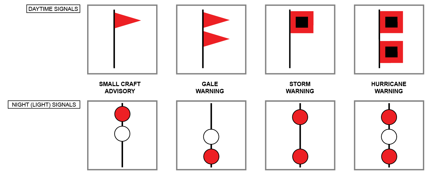
- Small Craft Advisories vs. Special Marine Warnings: It’s important to differentiate a Special Marine Warning from a Small Craft Advisory. A Small Craft Advisory is issued when sustained winds and or gusty winds of 20 to 33 knots (23 to 38 mph) are expected to produce hazardous conditions to small boats. A Special Marine Warning, however, signifies a higher level of threat, indicating winds of 34 knots or greater and/or other hazardous phenomena like waterspouts and severe thunderstorms. The transition from advisory to warning highlights a significant escalation in danger.
- Sudden Squalls and Microbursts: These are localized downdrafts of air originating from thunderstorms. They can produce sudden, intense bursts of wind that can quickly overwhelm a vessel, leading to loss of control and dangerous wave generation. The suddenness and localized nature of these events make them particularly hazardous, and Special Marine Warnings are designed to alert mariners to their presence.
Geographic Specificity and Communication Channels
The effectiveness of a Special Marine Warning hinges on its ability to reach the intended audience in a timely manner. This necessitates a precise definition of the affected area and the utilization of appropriate communication channels.
- Defined Marine Zones: Special Marine Warnings are issued for specific marine zones, which are predefined geographical areas over bodies of water. These zones are typically based on bays, sounds, coastal waters, and even large lakes. This allows mariners to quickly understand if their current location or planned route is affected. The NWS uses specific zone names (e.g., “Coastal waters from Sandy Hook to Surf City NJ out 20 nm”) to clearly delineate the warning area.
- Dissemination Methods: The NWS employs a multi-pronged approach to disseminate Special Marine Warnings. These include:
- NOAA Weather Radio: This is a primary source of real-time weather information for mariners. Special Marine Warnings are broadcast over NOAA Weather Radio All Hazards frequencies, often with specific audible alerts to draw attention.
- Marine VHF Radio: Warnings are transmitted over Marine Band VHF radio channels, typically Channel 16 (the international distress and calling channel) or other designated working channels, allowing mariners to receive critical updates directly.
- Internet and Mobile Applications: Many websites and mobile applications dedicated to weather forecasting and marine information provide real-time access to Special Marine Warnings. This includes the NWS website itself, as well as various third-party weather services.
- Navigational Systems: Increasingly, integrated navigational systems on larger vessels can receive and display weather warnings directly, providing an additional layer of situational awareness.
The Practical Implications for Mariners: Safety and Preparedness
Receiving a Special Marine Warning is a clear signal that immediate action is required to ensure safety. The decision-making process for mariners hinges on understanding the implications of the warning and having a plan in place.
Immediate Actions Upon Receiving a Warning

When a Special Marine Warning is issued for a mariner’s current location or projected route, a series of immediate actions should be considered:
- Assess the Severity and Threat: Understand what specific weather phenomena the warning pertains to (e.g., high winds, waterspouts). This will inform the appropriate response.
- Seek Shelter or Safe Harbor: The safest course of action is often to head for a safe harbor or a protected anchorage. This may involve altering course significantly and potentially delaying or canceling the planned voyage.
- Secure the Vessel: If immediate shelter is not possible, mariners must secure their vessel to withstand the expected conditions. This includes:
- Reducing Sail: For sailboats, this means lowering sails to their smallest manageable size or furling them completely.
- Securing Gear: All loose items on deck and in the cockpit must be stowed and secured to prevent them from being washed overboard or causing damage.
- Ensuring Watertight Integrity: Closing all hatches, ports, and companionways to prevent water ingress.
- Monitor Weather and Communications: Continue to monitor weather updates via NOAA Weather Radio or other reliable sources. Maintain a vigilant watch for changing conditions.
- Inform Others: If operating as part of a fleet or if expected back at a certain time, communicate any delays or changes in plans to shore contacts.
The Importance of Proactive Planning
While Special Marine Warnings are reactive alerts to immediate threats, their effectiveness is amplified by proactive planning:
- Pre-Voyage Weather Checks: Before departing, always check the marine forecast and be aware of any potential for hazardous weather. This includes understanding the typical weather patterns for the season and region.
- Vessel Condition and Equipment: Ensure the vessel is in good condition and equipped with necessary safety gear, including life jackets, flares, first-aid kits, and communication devices.
- Route Planning and Contingencies: Plan routes that allow for safe harbor access and have contingency plans in place in case of unexpected weather. Consider alternative routes or the option to postpone the trip.
- Crew Briefing: Brief all crew members on potential hazards, emergency procedures, and their roles in case of severe weather. Familiarity with safety protocols is crucial.
- Understanding Marine Forecast Terminology: Beyond Special Marine Warnings, understanding other marine forecast products (e.g., Small Craft Advisories, Gale Warnings, Storm Warnings) is essential for a comprehensive understanding of maritime weather risks.
Beyond the Immediate: The Role of Technology in Marine Weather Safety
The issuance and dissemination of Special Marine Warnings, along with the mariner’s ability to respond effectively, have been significantly enhanced by technological advancements.
Advanced Forecasting and Detection
The science behind issuing Special Marine Warnings relies on sophisticated meteorological tools:
- Doppler Radar: Doppler radar systems are crucial for detecting the precipitation, wind speed, and direction within thunderstorms. This allows forecasters to identify the signatures of severe wind gusts, hail, and even potential tornado formation.
- Satellite Imagery: Satellite data provides a broad overview of weather systems, helping forecasters to track the development and movement of storms over large bodies of water.
- Buoy Data and Ship Reports: Real-time data from buoys and voluntary observations from ships at sea provide ground truth and immediate feedback on current weather conditions, helping to verify forecasts and issue timely warnings.
- Numerical Weather Prediction Models: Advanced computer models simulate atmospheric conditions and predict the evolution of weather systems. While these models are not always precise enough for highly localized warnings, they provide the foundational information for forecasting storm development.
Enhancements in Communication and Navigation
Technology has revolutionized how mariners receive and act upon weather information:
- Digital Marine Radios: Modern VHF radios offer clearer communication and can often display text-based weather alerts.
- GPS and Chartplotters: Integrated GPS and chartplotter systems can display weather overlays, including warning areas, directly on navigational charts, providing mariners with crucial spatial context.
- Smartphones and Weather Apps: The proliferation of smartphones and dedicated weather applications has made real-time weather information more accessible than ever before. Many apps can provide push notifications for Special Marine Warnings affecting a user’s current location or pre-defined areas.
- Personal Locator Beacons (PLBs) and Satellite Messengers: In the event of an emergency, these devices can transmit distress signals with location data, facilitating rescue efforts. While not directly related to receiving warnings, they are vital safety tools for mariners operating in remote or unpredictable conditions.
- AIS (Automatic Identification System) Integration: Increasingly, weather data is being integrated into AIS systems, allowing vessels to share and receive real-time weather information with other nearby vessels and shore-based services.
Conclusion: A Vital Tool for Maritime Safety
In essence, a Special Marine Warning is a critical alert system designed to protect lives and property on the water. It signifies an immediate and localized threat from severe weather, requiring swift and decisive action from mariners. The precision of these warnings, coupled with advancements in forecasting technology and dissemination methods, has made them an indispensable component of maritime safety. By understanding what a Special Marine Warning is, its implications, and the best practices for responding to them, mariners can navigate the inherent risks of the marine environment with greater confidence and security. Staying informed, planning meticulously, and respecting the power of the weather are the cornerstones of a safe and enjoyable experience on the water.
aViewFromTheCave is a participant in the Amazon Services LLC Associates Program, an affiliate advertising program designed to provide a means for sites to earn advertising fees by advertising and linking to Amazon.com. Amazon, the Amazon logo, AmazonSupply, and the AmazonSupply logo are trademarks of Amazon.com, Inc. or its affiliates. As an Amazon Associate we earn affiliate commissions from qualifying purchases.