The name Krakatoa evokes images of cataclysmic power, a force of nature so immense it reshaped global weather patterns and left an indelible mark on history. The colossal 1883 eruption, one of the deadliest and most well-documented volcanic events, serves as a stark reminder of Earth’s dynamic and often destructive geological processes. But beyond its historical significance, Krakatoa represents a profound scientific puzzle: understanding the intricate mechanisms that drive such powerful volcanoes. At its heart lies a fundamental question – what type of volcano is Krakatoa? Answering this, and predicting similar future events, is no longer solely the domain of intrepid field geologists. It has become a sophisticated enterprise powered by an array of cutting-edge technologies, transforming volcanology into a highly data-driven science.
This article explores how advancements in technology are instrumental in classifying, understanding, and continuously monitoring active volcanoes like Krakatoa. From satellite-based remote sensing to AI-driven predictive models, technology provides the eyes, ears, and analytical power necessary to decode the complex language of the Earth’s fiery giants.
The Geological Identity of Krakatoa: A Primer Through Tech’s Lens
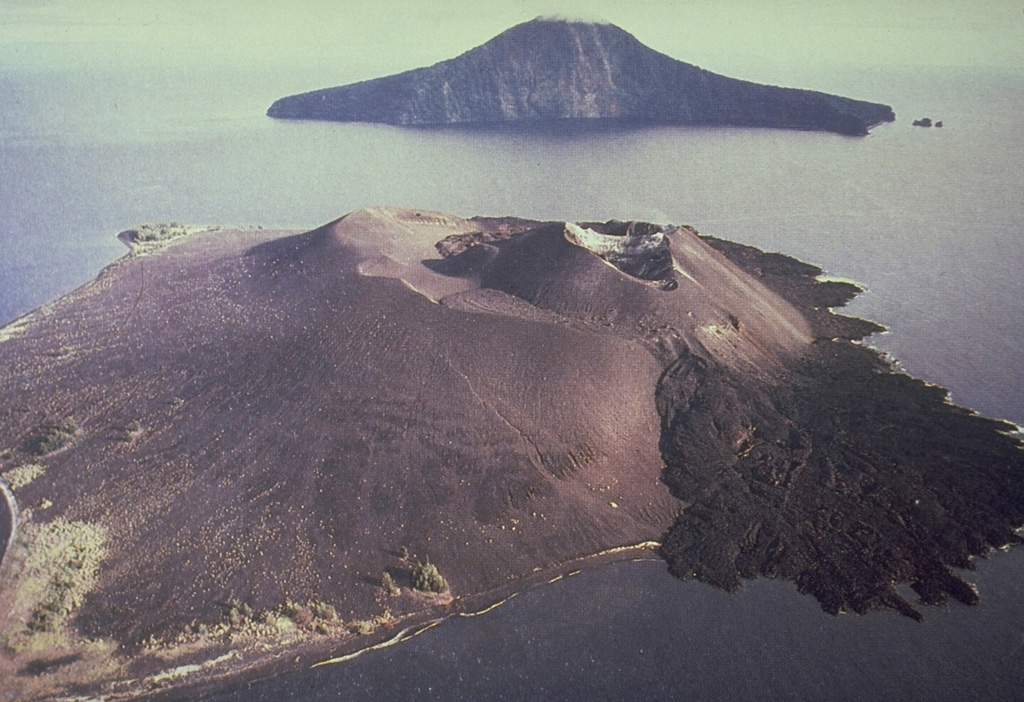
To understand Krakatoa, we must first categorize it geologically. Krakatoa (and its modern incarnation, Anak Krakatau or “Child of Krakatoa”) is classified primarily as a stratovolcano, also known as a composite volcano. These are among the most iconic and dangerous types of volcanoes, characterized by their conical shape, steep slopes, and explosive eruptions. Technology plays a crucial role not only in confirming this classification but also in dissecting the nuanced characteristics that define it.
Stratovolcanoes Explained: Remote Sensing and Structural Insights
Stratovolcanoes are built up over thousands of years by layers of hardened lava, tephra, pumice, and volcanic ash. Their formation is typically associated with subduction zones, where one tectonic plate slides beneath another. The magma involved in stratovolcanoes is often viscous, leading to pressure buildup and highly explosive eruptions.
High-resolution satellite imagery and digital elevation models (DEMs) derived from Synthetic Aperture Radar (SAR) or LiDAR technology are invaluable in identifying and mapping the morphology of stratovolcanoes. These tools allow volcanologists to precisely measure the conical shape, detect past lava flows, identify crater structures, and even monitor changes in the volcano’s edifice over time. For Krakatoa, historical and contemporary satellite data confirm its composite structure, showing evidence of multiple eruptive phases building up its cone. By analyzing these digital topographical maps, scientists can infer the type of material ejected in past eruptions and understand the growth patterns characteristic of stratovolcanoes.
Subduction Zones and Magma Composition: Analyzing Seismic and Gas Data
The explosive nature of stratovolcanoes is closely linked to the composition of their magma – typically intermediate to felsic, rich in silica, and containing significant amounts of dissolved gases. Technology allows us to peer beneath the surface to understand these crucial factors.
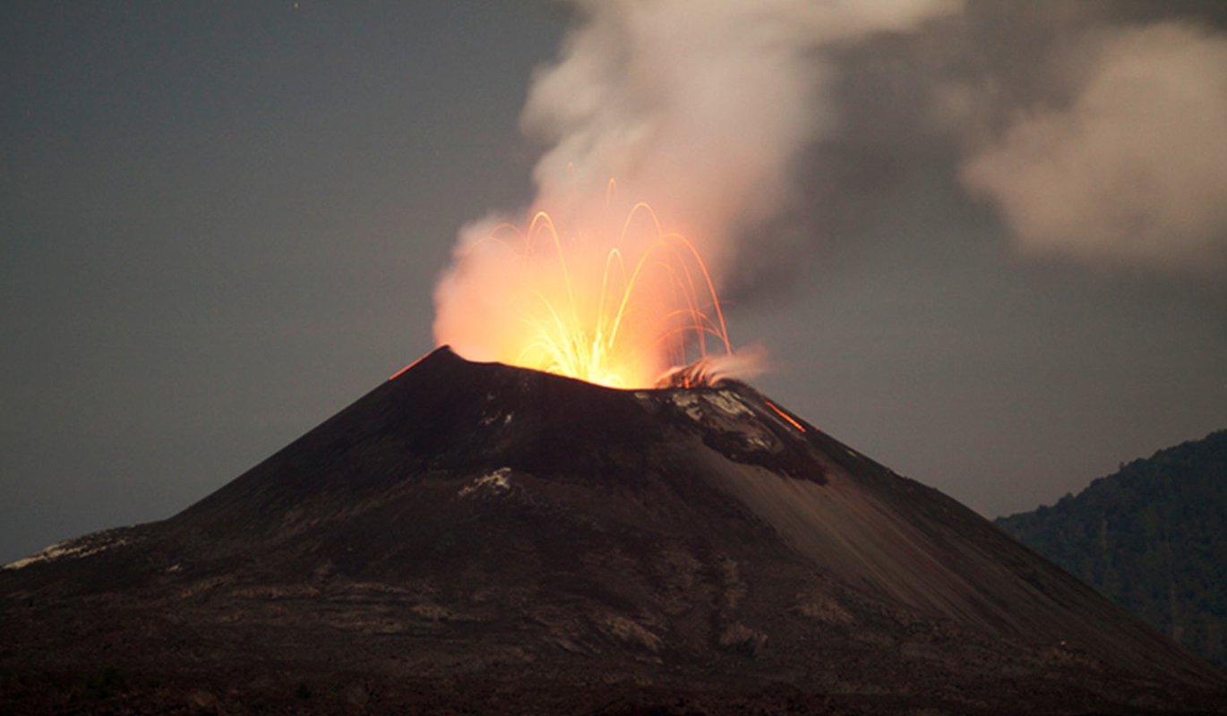
Seismic networks deploy sensitive seismometers around volcanic areas to detect ground tremors caused by magma movement. Data from these networks, often transmitted in real-time via satellite or fiber optics, provides critical insights into the depth, volume, and migration paths of magma chambers. Spectroscopic analysis of volcanic gases, either collected directly by drones or observed remotely from satellites, reveals the chemical composition of the magma and the concentration of gases like sulfur dioxide ($text{SO}2$) and carbon dioxide ($text{CO}2$). Changes in gas ratios can signal shifts in magma depth or a buildup of pressure, critical indicators of an impending eruption. For Krakatoa, located on the highly active Sunda Arc subduction zone, these technological tools confirm the presence of an underlying magma system consistent with stratovolcanic activity and subduction-related volcanism.
Advanced Monitoring: The Digital Eyes and Ears of Volcanoes
Understanding a volcano’s type is just the first step. The real challenge, and where technology truly shines, is in continuous, real-time monitoring to anticipate future activity. Modern volcanology is fundamentally a tech-driven endeavor, utilizing a diverse suite of instruments to observe, measure, and analyze every subtle change.
Seismic Networks and Real-time Data: Listening to the Earth’s Pulse
The Earth’s crust is constantly in motion, and beneath a volcano, this motion intensifies. Seismic monitoring networks are the backbone of any modern volcano observatory. Arrays of broadband seismometers are strategically placed around volcanic edifices to detect ground vibrations. These vibrations, ranging from subtle microseisms to more pronounced earthquake swarms, provide critical clues. Real-time data transmission via cellular networks, satellite uplinks, or dedicated radio links ensures that scientists receive immediate alerts for changes in seismic activity. Sophisticated software algorithms then process this raw data, differentiating between tectonic earthquakes, volcanic tremors, and rockfalls, providing a clear picture of magma migration, crack propagation, and gas movements within the volcanic system. This continuous auditory feedback loop allows volcanologists to “listen” to the internal processes of Anak Krakatau, identifying patterns that precede eruptions.
Satellite Surveillance and Remote Sensing: Eyes from Orbit
Satellites offer an unparalleled vantage point for observing volcanoes, especially in remote or hazardous areas like the Krakatoa archipelago.
Synthetic Aperture Radar Interferometry (InSAR) is a particularly powerful technique. It uses radar signals from orbiting satellites to detect minute changes (down to a few millimeters) in the ground surface, indicating inflation or deflation of the volcano caused by magma movement. Over time, InSAR data provides a precise deformation history of a volcano.
Thermal imaging satellites track temperature changes on the volcano’s surface, identifying hot spots or increased heat flux that can precede an eruption.
Optical satellites provide high-resolution imagery for visual changes, such as new vents, lava flows, or ash deposits. For Anak Krakatau, with its frequent smaller eruptions and rapid morphological changes, satellite surveillance is crucial for tracking its growth and activity without putting human lives at risk.
Gas Emission Analysis: Chemical Signatures of Activity

Volcanic gases are direct indicators of the magmatic processes beneath the surface. Monitoring their composition and flux is vital. While traditional methods involve physically collecting gas samples, technology has provided safer and more continuous alternatives.
DOAS (Differential Optical Absorption Spectroscopy) scanners are ground-based instruments that remotely measure the concentration of gases like $text{SO}_2$ in volcanic plumes.
FTIR (Fourier Transform Infrared) spectrometers can analyze a broader range of gases.
Increasingly, unmanned aerial vehicles (UAVs) or drones equipped with miniaturized gas sensors are being deployed. These drones can fly directly into volcanic plumes, collecting samples or making in-situ measurements in environments too dangerous for humans. The data collected provides real-time insights into magmatic degassing, helping to assess the likelihood and intensity of an eruption.
Predictive Power: AI, Machine Learning, and Simulation Models
The ultimate goal of volcano monitoring is prediction. While predicting the exact timing, size, or duration of an eruption remains an immense challenge, technology is significantly enhancing our predictive capabilities, moving beyond simple observation to sophisticated analysis and modeling.
AI in Pattern Recognition: Deciphering Pre-Eruptive Signals
Volcanic datasets are massive and complex, containing subtle patterns that might escape human detection. This is where Artificial Intelligence (AI) and Machine Learning (ML) algorithms prove invaluable. ML models can be trained on historical data from various volcanoes, learning to identify specific combinations of seismic activity, ground deformation, gas emissions, and thermal anomalies that often precede eruptions. For a volcano like Anak Krakatau, which has a well-documented eruptive history, AI can process years of monitoring data to detect anomalous patterns, potentially flagging early warning signs that would otherwise be missed. This shift from manual interpretation to automated, intelligent pattern recognition is a game-changer for early warning systems.
Computational Fluid Dynamics: Modeling Eruptive Scenarios
Once an eruption begins, or is deemed highly likely, understanding its potential impact is paramount. Computational Fluid Dynamics (CFD) models use powerful supercomputers to simulate the flow of lava, the trajectory of pyroclastic flows, and the dispersal of ash plumes. These models take into account topography, wind patterns, and eruption parameters to generate detailed hazard maps. For Krakatoa, these simulations are critical for understanding the potential reach of ash clouds, tsunamis generated by flank collapses (as seen in 2018 at Anak Krakatau), and the impact on surrounding populated areas, enabling better evacuation planning and risk mitigation strategies.
Integrated Risk Assessment Platforms: Data Fusion for Decision-Making
Modern volcano observatories are integrating all these diverse data streams – seismic, GPS, InSAR, gas, thermal, and meteorological – into unified data fusion platforms. These platforms utilize advanced analytics and visualization tools to present a comprehensive, real-time picture of a volcano’s state. By combining multiple lines of evidence, these systems provide a more robust basis for decision-making by authorities, informing public advisories, aviation warnings, and emergency response plans. The goal is to move towards a holistic, intelligent system that can interpret complex data and provide actionable intelligence with greater accuracy and speed.
The Future of Volcanology: Emerging Technologies
The technological revolution in volcanology is far from over. New innovations are continuously pushing the boundaries of what’s possible, promising even deeper insights and more effective risk management.
Robotics and Autonomous Systems: Exploring the Unreachable
The use of advanced robotics and autonomous systems is expanding rapidly. Beyond current drones, future robots could navigate inside active craters, collect samples from lava lakes, or deploy sensors in extremely hazardous locations, providing data from areas currently inaccessible to humans. These resilient machines will significantly reduce the risk to researchers while expanding the scope of data collection.
IoT and Sensor Networks: Pervasive Monitoring
The Internet of Things (IoT) paradigm, with its focus on interconnected smart devices, holds immense potential for volcanology. Dense networks of low-cost, low-power wireless sensors could be deployed across vast volcanic landscapes, providing unprecedented spatial and temporal coverage of ground deformation, gas emissions, and microseismic activity. This pervasive sensing capability would offer a more granular understanding of a volcano’s behavior, detecting subtle changes across its entire edifice.
Big Data and Cloud Computing: Unlocking Deeper Insights
The sheer volume of data generated by modern monitoring technologies requires robust infrastructure. Big Data analytics combined with cloud computing platforms will become even more central. These technologies enable the storage, processing, and analysis of vast, multi-parameter datasets on an unprecedented scale, facilitating complex modeling, AI training, and collaborative research among international teams.
Conclusion
Understanding “what type of volcano is Krakatoa” is a question that, while fundamentally geological, is now inextricably linked to the technological advancements that allow us to answer it with precision and detail. Krakatoa is a stratovolcano, a classification confirmed and continuously refined by satellite imagery, seismic analysis, and gas spectroscopy. More importantly, the lessons learned from Krakatoa’s destructive past drive the relentless innovation in volcanic monitoring. From sophisticated sensor networks to AI-driven predictive models, technology is not just observing volcanoes; it is actively deciphering their language, helping us to anticipate their moves, and ultimately, to coexist more safely with these magnificent and terrifying forces of nature. The future of volcanology lies firmly at the intersection of geology and cutting-edge technology, ensuring that the legacy of Krakatoa continues to inspire both scientific inquiry and technological advancement for generations to come.
aViewFromTheCave is a participant in the Amazon Services LLC Associates Program, an affiliate advertising program designed to provide a means for sites to earn advertising fees by advertising and linking to Amazon.com. Amazon, the Amazon logo, AmazonSupply, and the AmazonSupply logo are trademarks of Amazon.com, Inc. or its affiliates. As an Amazon Associate we earn affiliate commissions from qualifying purchases.