
While the vastness of hurricanes and the terrifying spectacle of tornadoes often dominate our understanding of severe weather, a more localized and equally dangerous phenomenon lurks in the skies: the microburst. Often described as a “downward gust of wind,” a microburst is a highly concentrated downdraft of air from a thunderstorm that, upon hitting the ground, spreads out horizontally with extreme force. These events, though typically lasting only a few minutes and covering a limited area, can unleash winds equivalent to those found in much larger storms, posing a significant threat to aviation, infrastructure, and anyone caught in their path.
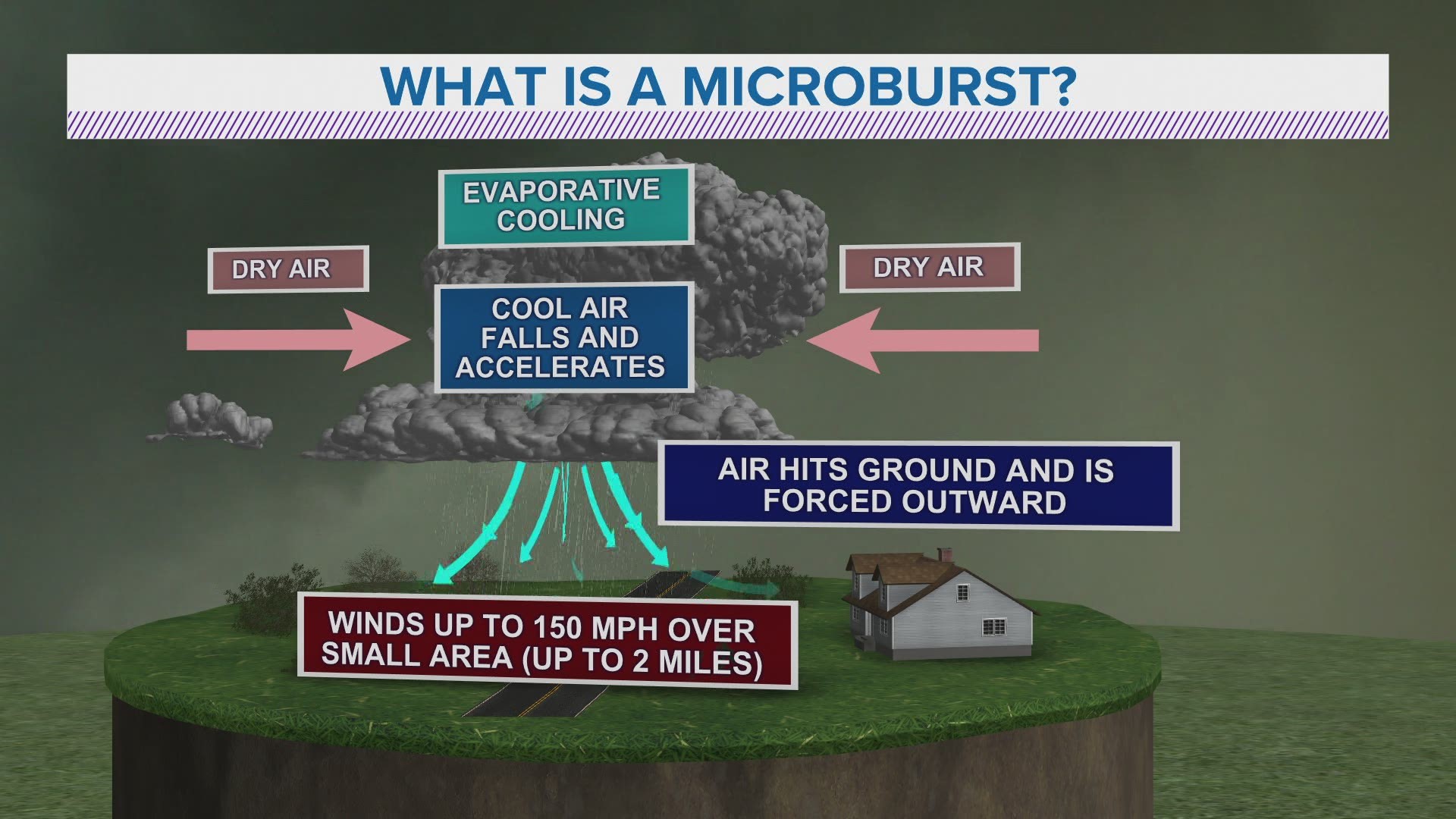
Understanding microbursts is crucial, not just for meteorologists and pilots, but for anyone who lives in or travels through regions prone to severe thunderstorms. The impact of a microburst can be devastating, and its sudden onset can leave little time for preparation. This article will delve into the mechanics of microbursts, their characteristics, the dangers they present, and how modern technology is helping us to detect, predict, and mitigate their effects.
The Anatomy of a Microburst: From Cloud to Chaos
The Genesis: Thunderstorms and Downdrafts
Microbursts are born within the turbulent heart of a thunderstorm. These powerful storms are characterized by strong updrafts and downdrafts, driven by the instability of the atmosphere and the release of latent heat as water vapor condenses into rain and hail. Within a thunderstorm, the downdraft is essentially air that is sinking. Several factors can contribute to the formation of a particularly strong downdraft that can evolve into a microburst:
- Rain Loading: As rain, or more commonly, hail, accumulates within a storm cloud, it becomes very heavy. This weight can drag the surrounding air downwards.
- Evaporational Cooling: As precipitation falls from the storm cloud into drier air below, it begins to evaporate. This process of evaporation requires energy, which it draws from the surrounding air, causing it to cool. Cooler air is denser than warmer air, and this increased density causes it to sink rapidly.
- Melting: Similar to evaporational cooling, the melting of ice particles (hail or graupel) into rain also absorbs heat from the air, leading to cooling and increased density.
The Descent: A Focused Plunge
When these downdraft-intensifying processes occur in a concentrated area within a thunderstorm, the sinking air can accelerate dramatically. This focused, powerful plunge of air is the initial stage of a microburst. Unlike a general downdraft that might spread out more diffusely, the air within a microburst is channeled and propelled downwards with immense force.
The Impact: The “Roll Cloud” and Outburst
Upon reaching the ground, the nature of the microburst changes dramatically. The dense, fast-moving column of air hits the surface and, unable to continue downwards, explodes outwards in all directions. This horizontal outflow of air is the most dangerous phase of a microburst. It creates a powerful surge of wind that can extend for several miles, though the most intense winds are usually confined to an area less than 2.5 miles (4 kilometers) in diameter.
A telltale sign of an approaching microburst, especially for those on the ground, can be the development of a “roll cloud” or a “shelf cloud” at the leading edge of the outflow. This feature is caused by the moist air being lifted and cooled as it spreads out from the impact point, leading to condensation.
Types of Microbursts: Wet vs. Dry
Microbursts are broadly categorized into two types, distinguished by the amount of precipitation associated with them:
Wet Microbursts
These are the more commonly observed and visually apparent microbursts. They are associated with thunderstorms that produce significant rainfall. The rain, in conjunction with the evaporational cooling and air loading processes, contributes to the powerful downdraft. The visual cues of a wet microburst include heavy rain shafts that appear to be hitting the ground with extreme force, often accompanied by lightning and thunder.
Dry Microbursts
Dry microbursts are more insidious because they can occur with little to no visible rain reaching the ground. The precipitation that initiates the downdraft forms high up in the thunderstorm and evaporates completely before it reaches the surface. This makes them harder to detect visually and therefore, more dangerous, especially to aircraft. The primary driver of a dry microburst is the evaporational cooling of precipitation that never makes it to the ground. While rain might be absent at the surface, the cooling effect is just as potent.
The Perils of Microbursts: A Threat to Aviation and Beyond
The concentrated, rapidly changing wind patterns associated with microbursts pose a severe hazard, particularly to aviation. The danger is so significant that microbursts are considered one of the most critical weather threats to aircraft.
Aviation’s Nemesis: Wind Shear

The primary danger of a microburst to aircraft lies in the phenomenon of wind shear. Wind shear refers to a sudden change in wind speed or direction over a short distance. In the case of a microburst, an aircraft can experience a sequence of devastating wind changes:
- Headwind Increase: As the aircraft approaches the microburst’s downdraft core, it encounters an increasing headwind. This causes the aircraft to gain altitude and airspeed unexpectedly.
- Downdraft: The aircraft then enters the strong downward moving air of the downdraft. This pushes the aircraft towards the ground.
- Tailwind Surge: As the aircraft exits the downdraft core and encounters the outward spreading outflow, it is hit by a strong tailwind. This sudden loss of airspeed can be catastrophic, especially at low altitudes when a pilot has less room to recover.
This rapid sequence of wind changes can overwhelm an aircraft’s ability to maintain lift and control, especially during critical phases of flight like takeoff and landing when aircraft are operating at lower speeds and altitudes. The classic example of a microburst tragedy is the 1985 crash of Delta Air Lines Flight 191 in Dallas, Texas, which killed 137 people and was directly attributed to a microburst.
Beyond Aviation: Threats to Ground Operations and Infrastructure
While aviation is the most critically affected, microbursts can also pose risks to people and property on the ground:
- Structural Damage: The intense, outward-spreading winds can damage roofs, knock down trees, and overturn unsecured objects. While not on the same scale as a tornado, localized damage can be significant.
- Power Outages: Falling trees and debris can easily sever power lines, leading to widespread and prolonged outages.
- Threat to Outdoor Activities: Anyone engaged in outdoor activities, such as hiking, camping, or sporting events, can be caught off guard by the sudden onset of violent winds, leading to injury or worse.
Technological Advancements in Microburst Detection and Prediction
The understanding of microbursts and the development of technologies to detect and predict them have significantly improved flight safety and public awareness. This progress has been a direct result of dedicated research and investment in meteorological tools.
Doppler Radar: The Eyes in the Sky
The advent of Doppler radar has revolutionized microburst detection. Unlike conventional weather radar that only measures precipitation intensity, Doppler radar can measure the velocity of precipitation particles, both towards and away from the radar. This capability allows meteorologists to detect the characteristic “divergence” pattern of a microburst:
- Velocity Signatures: In a microburst, Doppler radar will show air moving rapidly towards the radar on one side of the storm and rapidly away from the radar on the opposite side. This creates a visual “signature” on the radar display that is indicative of a strong downdraft impacting the ground and spreading out.
- TVS (Tornado Vortex Signature) vs. MVS (Microburst Vortex Signature): While Doppler radar can also detect tornadoes (often characterized by a swirling vortex), microbursts exhibit a distinct divergence pattern rather than a rotational one. Advanced algorithms can differentiate between these phenomena.
Terminal Doppler Radar (TDR) and LLWAS (Low-Level Wind Shear Alert System)
To specifically address the aviation threat, specialized radar systems have been deployed at airports:
- Terminal Doppler Radar (TDR): These systems are designed to provide real-time wind shear information for the immediate vicinity of an airport. They can detect microbursts developing or impacting the airport environment, providing critical warnings to pilots.
- Low-Level Wind Shear Alert System (LLWAS): This system uses a network of anemometers (wind speed sensors) installed around an airport to detect wind shear. When a significant difference in wind speed or direction is detected between different anemometers, an alert is issued.
Numerical Weather Prediction and AI
Beyond direct detection, advances in numerical weather prediction (NWP) models are improving the ability to forecast the conditions conducive to microburst development. These complex computer models simulate atmospheric conditions and can identify areas with a high probability of severe thunderstorms capable of producing microbursts.
Furthermore, the application of Artificial Intelligence (AI) and Machine Learning (ML) is beginning to play a crucial role. AI algorithms can process vast amounts of weather data from various sources, including satellite imagery, radar data, and NWP model outputs, to identify subtle patterns that might precede a microburst. This can lead to earlier and more accurate warnings. AI is also being used to:
- Enhance Radar Data Interpretation: AI can sift through complex radar signatures, identifying microbursts with greater speed and accuracy than human analysts alone.
- Predict Microburst Intensity and Duration: Advanced ML models are being trained to estimate the potential severity and lifespan of a microburst based on atmospheric conditions.
- Improve Warning Dissemination: AI-powered systems can help automate the process of issuing warnings, ensuring that crucial information reaches pilots and the public more rapidly.

The Synergy of Technology and Human Expertise
It is important to note that while technology is invaluable, it is not a complete replacement for human expertise. Meteorologists and air traffic controllers play a vital role in interpreting radar data, understanding the limitations of technology, and making critical decisions based on the best available information. The synergy between advanced technological tools and experienced human judgment is the most effective defense against the hazards posed by microbursts.
In conclusion, microbursts, though small in geographical scope, pack a punch that can rival much larger weather events. Understanding their formation, characteristics, and the dangers they present is essential. Thanks to ongoing advancements in Doppler radar, specialized airport systems, and the burgeoning fields of numerical weather prediction and AI, our ability to detect, predict, and ultimately mitigate the risks associated with these powerful downdrafts continues to improve, making our skies and our communities safer.
aViewFromTheCave is a participant in the Amazon Services LLC Associates Program, an affiliate advertising program designed to provide a means for sites to earn advertising fees by advertising and linking to Amazon.com. Amazon, the Amazon logo, AmazonSupply, and the AmazonSupply logo are trademarks of Amazon.com, Inc. or its affiliates. As an Amazon Associate we earn affiliate commissions from qualifying purchases.