
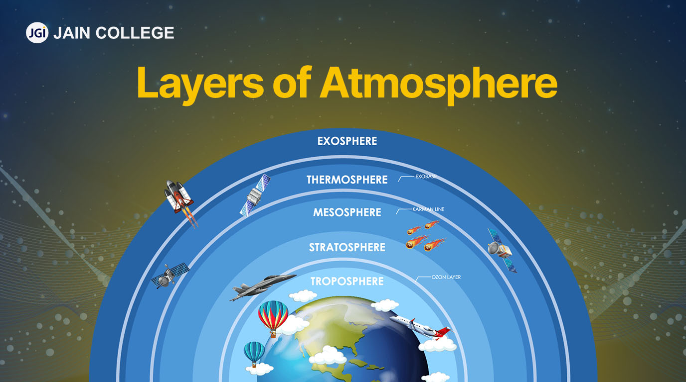
The deceptively simple question, “what layer of the atmosphere does weather occur?”, unlocks a profound discussion not only about Earth’s intricate systems but also about the relentless march of technological innovation. At its core, the answer lies in the troposphere, the lowest and densest layer of Earth’s atmosphere, extending from the surface up to about 7–20 km (4–12 miles) depending on latitude and season. This is where we live, breathe, and experience the full gamut of atmospheric phenomena – from gentle breezes and sunny skies to torrential downpours, thunderstorms, and blizzards.

However, simply identifying the troposphere is merely the starting point. Understanding how weather occurs, why it changes, and what its future might hold requires an extensive and sophisticated technological infrastructure. In an era defined by data, artificial intelligence, and interconnected systems, meteorology has evolved from an observational science to a highly computational and predictive discipline. Technology doesn’t just help us observe the troposphere; it allows us to model its complexities, anticipate its whims, and ultimately, harness its data for myriad applications, from agricultural planning and energy management to disaster preparedness and urban development. This article delves into the technological marvels that empower us to decode the dynamic processes within the troposphere, transforming raw atmospheric data into actionable insights for a global society.
The Troposphere Unveiled: A Technological Perspective
The troposphere is a swirling, dynamic cauldron of air, moisture, and energy, directly influenced by Earth’s surface and solar radiation. Its characteristics – temperature gradients, pressure variations, and the presence of water vapor – are the fundamental ingredients for all weather events. From the smallest dewdrop to the most colossal hurricane, every atmospheric spectacle unfolds within this vital layer. Yet, perceiving and quantifying these subtle and often rapid changes across vast geographical areas has historically been a monumental challenge.
Defining the Dynamic “Weather Layer”
The troposphere is distinguished by a steady decrease in temperature with altitude, driven by the absorption of solar radiation at the Earth’s surface and subsequent re-emission. This temperature gradient creates convection currents – the rising of warm air and sinking of cool air – which are critical drivers of weather. The presence of water vapor, concentrated in this lowest layer, further amplifies its dynamism, leading to cloud formation, precipitation, and latent heat release that fuels storms. Without the technological tools to measure temperature, humidity, pressure, and wind speed at various altitudes, our understanding of these processes would remain rudimentary. Early attempts relied on manual observations from ground stations, balloons, and limited aerial surveys, offering only fragmented snapshots of an ever-changing system. The sheer scale and rapid evolution of atmospheric phenomena necessitate tools that can collect vast amounts of data quickly and continuously, transcending human limitations.
Early Innovations in Atmospheric Observation
While modern meteorology is heavily reliant on advanced computing, its foundational technologies emerged centuries ago. The invention of the thermometer (Galileo, 17th century), barometer (Torricelli, 17th century), and hygrometer (Da Vinci, 15th century, but perfected later) provided the first quantitative means to measure key atmospheric variables. These instruments, initially curiosities, became indispensable tools for early meteorologists, allowing them to track basic changes in air temperature, pressure, and humidity. The development of the telegraph in the 19th century revolutionized weather forecasting by enabling rapid sharing of observations across distances, leading to the first synoptic weather maps and rudimentary storm warnings. These early technological leaps, though primitive by today’s standards, laid the groundwork for the complex networks and sophisticated analyses that characterize contemporary atmospheric science. They demonstrated the profound impact that innovative tools could have on our ability to understand and predict the weather, setting the stage for the digital revolution in meteorology.
Sensors and Satellites: The Eyes in the Sky and On the Ground
The ability to collect comprehensive, real-time data from across the troposphere is paramount for accurate weather prediction. This capability is almost entirely thanks to a sprawling network of interconnected sensors and advanced satellite technologies that provide an unprecedented view of our atmosphere.
The Ubiquitous IoT Weather Station Network
At the ground level, the Internet of Things (IoT) has dramatically expanded our observational capabilities. Thousands of automated weather stations, equipped with an array of sensors, continuously measure temperature, humidity, wind speed and direction, atmospheric pressure, and precipitation. These stations, ranging from professional meteorological observatories to amateur weather enthusiasts’ backyard setups, are often connected to the internet, streaming real-time data to central databases. This dense network provides invaluable hyperlocal information, filling critical gaps that larger-scale observation systems might miss. Beyond traditional stations, smart city infrastructure, agricultural sensors, and even personal devices are increasingly contributing to this rich tapestry of ground-level atmospheric data, offering granular insights into microclimates and localized weather events. The aggregation and analysis of this vast dataset are only possible through powerful computing platforms capable of ingesting and processing petabytes of information.
Satellite Technology: Global Monitoring and Data Collection
Ascending above the Earth, a constellation of weather satellites forms the backbone of global atmospheric monitoring. Geostationary satellites, orbiting at an altitude of approximately 35,786 kilometers (22,236 miles) and remaining fixed relative to a point on the Earth’s surface, provide continuous, real-time imagery of large weather systems, tracking their movement and evolution. Polar-orbiting satellites, flying over the poles at lower altitudes, offer higher-resolution data and comprehensive global coverage over multiple passes, capturing detailed information on atmospheric temperature and moisture profiles, cloud structure, and ocean surface conditions. These satellites utilize a variety of instruments, including visible and infrared imagers, microwave sounders, and radiometers, to peer through clouds and gather data on parameters crucial for forecasting. The sheer volume and diversity of data streamed from these orbital sentinels—images, spectra, and atmospheric profiles—are critical for global weather models and climate monitoring, allowing meteorologists to observe phenomena from developing tropical cyclones to vast stretches of atmospheric moisture.
Radar and Lidar: Peering into Storms
For a closer look at precipitation and atmospheric particles, radar (Radio Detection and Ranging) and lidar (Light Detection and Ranging) technologies are indispensable. Weather radar systems emit radio waves that bounce off precipitation particles (rain, snow, hail) and return to the receiver, providing information on the intensity, location, and movement of precipitation. Doppler radar, a more advanced form, also measures the speed and direction of precipitation, allowing meteorologists to detect rotation within thunderstorms—a key indicator of tornado development. Lidar, on the other hand, uses pulsed laser light to measure distances to atmospheric aerosols, clouds, and other particles, offering highly detailed vertical profiles of the atmosphere. It’s particularly useful for detecting clear-air turbulence, volcanic ash, and analyzing cloud structures. Together, radar and lidar provide vital, high-resolution data that complements satellite imagery and ground observations, offering a comprehensive, multi-dimensional view of the troposphere’s most dynamic and often destructive processes.
AI and Machine Learning: Powering Predictive Analytics
The torrent of data generated by sensors and satellites would be overwhelming without advanced analytical tools. This is where artificial intelligence (AI) and machine learning (ML) have become transformative, revolutionizing how we process atmospheric data and generate increasingly accurate forecasts.
From Numerical Models to Deep Learning Algorithms
For decades, numerical weather prediction (NWP) models have been the gold standard. These complex mathematical models simulate the physics of the atmosphere, solving equations that govern fluid dynamics, thermodynamics, and radiative transfer on supercomputers. While incredibly powerful, NWP models are computationally intensive and can be limited by the initial conditions and parameterizations of physical processes. AI and ML are now complementing and, in some cases, beginning to supersede aspects of traditional NWP. Deep learning algorithms, trained on decades of historical weather data and NWP model outputs, can identify intricate patterns and relationships that might be missed by human analysis or explicit physical equations. These AI models can learn to correct biases in NWP models, downscale forecasts to higher resolutions, and even generate entirely new forecast products. They excel at pattern recognition, making them particularly adept at predicting complex, localized phenomena like severe thunderstorms or sudden temperature shifts with greater speed and efficiency.
Enhanced Accuracy and Granularity in Forecasting
The application of AI and ML leads directly to more accurate and granular weather forecasts. By rapidly analyzing vast datasets and recognizing subtle precursors to specific weather events, AI models can improve the lead time for warnings and reduce forecast errors. For instance, AI can process satellite imagery to detect rapidly developing storm cells or analyze sensor data to predict localized fog formation with precision. This enhanced granularity means not just knowing if it will rain, but where and when with greater certainty, even down to a neighborhood level. This level of detail is critical for industries like agriculture, which can optimize planting and harvesting schedules; transportation, which can plan routes to avoid adverse conditions; and renewable energy, which can better predict solar and wind power generation. The ability of AI to learn from its own predictions and continuously refine its models means that forecasting capabilities are in a constant state of improvement.
Personalization and Hyperlocal Weather Insights
Beyond general forecasts, AI is driving the era of personalized and hyperlocal weather insights. Mobile weather apps, powered by sophisticated algorithms, can now provide minute-by-minute precipitation forecasts for specific street addresses, often integrating data from local networks of amateur weather stations and even individual smartphone sensors. This hyper-personalization allows users to make immediate, informed decisions about their daily activities, whether it’s knowing exactly when to step out for a walk or if they need to grab an umbrella for their commute. Furthermore, AI systems can tailor weather information to specific user profiles or industry needs, filtering out irrelevant data and highlighting critical thresholds. For instance, a farmer might receive alerts when soil moisture levels drop below a certain point, while a utility company receives warnings about potential high-wind events impacting power lines. This bespoke delivery of weather intelligence underscores the power of AI to make complex atmospheric data immediately relevant and actionable for individuals and specialized sectors alike.
Big Data and Cloud Computing: The Infrastructure of Modern Meteorology
The continuous stream of data from global observation systems and the demands of sophisticated AI models require a robust digital infrastructure. Big data analytics and cloud computing are the twin pillars supporting modern meteorology, enabling the storage, processing, and dissemination of atmospheric information on an unprecedented scale.
Managing Petabytes of Atmospheric Data
Every day, weather satellites, ground sensors, radar systems, and atmospheric models generate petabytes of data—a volume that would have been unimaginable just a few decades ago. This “big data” includes raw sensor readings, satellite imagery, model outputs, historical records, and climate reanalysis datasets. Managing this deluge of information is a monumental challenge. Traditional databases and localized servers simply cannot cope with the velocity, volume, and variety of meteorological data. Big data platforms, incorporating distributed storage solutions and specialized databases, are essential for ingesting, organizing, and archiving this information efficiently. These systems are designed to handle massive, high-velocity data streams, ensuring that meteorologists and researchers have access to comprehensive datasets for analysis, model training, and historical trend identification. The ability to store and quickly retrieve decades of atmospheric data is fundamental not just for daily forecasting but also for long-term climate monitoring and research.
Cloud Platforms for Collaborative Research and Dissemination
Cloud computing has transformed the landscape of meteorological research and operations. By offering scalable computing resources on demand, cloud platforms allow national weather services, research institutions, and even private companies to run complex numerical models, train sophisticated AI algorithms, and process vast datasets without the prohibitive cost of owning and maintaining massive supercomputing infrastructure. This scalability is crucial during peak demand, such as when running multiple ensemble forecasts for a severe weather event. Beyond raw processing power, cloud environments foster collaboration. Researchers from different institutions can access shared datasets and models, contributing to a global understanding of atmospheric phenomena. Furthermore, cloud-based data dissemination allows weather information to be distributed rapidly and reliably to a wide array of users—from aviation companies and emergency services to media outlets and individual consumers—ensuring that critical forecasts and warnings reach their intended audience promptly and efficiently.
Democratizing Access to Weather Intelligence
One of the most significant impacts of big data and cloud computing in meteorology is the democratization of access to weather intelligence. Historically, high-resolution weather data and advanced forecasting capabilities were primarily the domain of national meteorological agencies and large corporations. Now, with data hosted in the cloud and APIs (Application Programming Interfaces) available, smaller businesses, startups, and even individual developers can tap into rich meteorological datasets and integrate them into their own applications and services. This has spurred innovation across various sectors. Agri-tech startups can offer precision farming solutions based on hyperlocal weather forecasts. Logistics companies can optimize supply chains by predicting weather impacts on routes. Energy companies can manage grid stability by anticipating demand fluctuations caused by temperature changes. This widespread access to sophisticated weather information, powered by cloud-based big data infrastructure, is creating a new ecosystem of weather-dependent applications and services, making meteorology a crucial component of the digital economy.
Future Horizons: Innovation in Climate Tech and Atmospheric Science
The technological revolution in understanding the troposphere is far from over. As climate change increasingly impacts weather patterns, and as our demand for precise atmospheric information grows, the pace of innovation in climate tech and atmospheric science continues to accelerate.
Advanced Sensing and Drone Technology
The next generation of atmospheric sensing will be even more dynamic and ubiquitous. Miniaturized sensors, often integrated into autonomous platforms like drones and high-altitude pseudo-satellites (HAPS), promise to provide unprecedented spatio-temporal resolution for atmospheric measurements. Drones can be deployed rapidly into hazardous areas, such as hurricanes or volcanic plumes, collecting direct in-situ data that satellites cannot provide and that traditional aircraft cannot safely acquire. Swarms of intelligent drones, working cooperatively, could map entire atmospheric volumes, providing real-time 3D models of local weather systems. Furthermore, advancements in passive remote sensing (e.g., using signals of opportunity like Wi-Fi or cellular networks) and active sensing (e.g., advanced multi-frequency radar and lidar) will enhance our ability to detect and quantify atmospheric phenomena with greater precision, even in challenging conditions. These mobile and highly adaptable sensing platforms will bridge the gap between ground-based stations and orbital satellites, offering critical data for nowcasting and localized short-term forecasting.
AI-Driven Climate Modeling and Intervention
Artificial intelligence is set to play an even more dominant role in climate modeling and, potentially, in climate intervention strategies. While current climate models are incredibly complex, AI can help address some of their biggest limitations, such as resolving small-scale processes and reducing computational costs. Deep learning could accelerate climate simulations by learning complex atmospheric physics, allowing for more detailed projections and uncertainty quantification. Beyond prediction, AI might become a tool in understanding and optimizing potential climate intervention technologies, such as carbon capture or solar radiation management. While these interventions are highly controversial and still largely experimental, AI could help model their complex atmospheric impacts, risks, and effectiveness with greater accuracy than current methods. Furthermore, AI-driven digital twins of Earth’s atmosphere could allow scientists to run endless “what if” scenarios, testing various climate policies and interventions virtually before implementation.
The Interconnected Weather Ecosystem
The future of weather technology envisions an even more interconnected ecosystem. Data from every conceivable source—satellites, ground sensors, drones, autonomous vehicles, smart city infrastructure, and even wearable tech—will be seamlessly integrated and processed by federated AI systems. This “Internet of Weather” will create a truly holistic picture of the troposphere, providing dynamic, self-correcting models that learn and adapt in real-time. Forecasts will become not just predictive but prescriptive, offering tailored recommendations for action across various sectors. Imagine smart grids that automatically adjust energy distribution based on hyper-local wind and solar forecasts, or smart farms that autonomously control irrigation systems based on precise soil moisture and precipitation predictions. This interconnected ecosystem will blur the lines between weather forecasting, climate science, and practical application, ushering in an era where our interaction with the troposphere is mediated and optimized by an invisible but ever-present layer of advanced technology.

Conclusion
The question “what layer of the atmosphere does weather occur?” is a gateway to understanding one of Earth’s most vital and dynamic systems: the troposphere. Yet, our ability to truly comprehend, predict, and adapt to the weather within this layer is not a static scientific discovery, but a continuous technological endeavor. From the earliest thermometers to the latest AI-powered supercomputers and satellite constellations, technology has served as our indispensable lens into the atmospheric engine.
We’ve seen how ground-based IoT sensors provide granular data, while satellites offer a global perspective, and radar systems peer into the heart of storms. Artificial intelligence and machine learning transform these vast datasets into increasingly accurate and personalized forecasts, empowering individuals and industries alike. Behind this computational prowess, big data platforms and cloud computing provide the essential infrastructure for storing, processing, and democratizing access to this wealth of information.
As we look to the future, advanced drone technology, more sophisticated AI models, and an increasingly interconnected weather ecosystem promise to further refine our understanding and extend our capabilities. The troposphere remains the stage for Earth’s weather, but it is through a relentless pursuit of technological innovation that we continue to decode its mysteries, mitigate its hazards, and harness its insights for the benefit of all. In essence, the layer where weather occurs is now, more than ever, a layer illuminated, analyzed, and navigated by cutting-edge technology.
aViewFromTheCave is a participant in the Amazon Services LLC Associates Program, an affiliate advertising program designed to provide a means for sites to earn advertising fees by advertising and linking to Amazon.com. Amazon, the Amazon logo, AmazonSupply, and the AmazonSupply logo are trademarks of Amazon.com, Inc. or its affiliates. As an Amazon Associate we earn affiliate commissions from qualifying purchases.