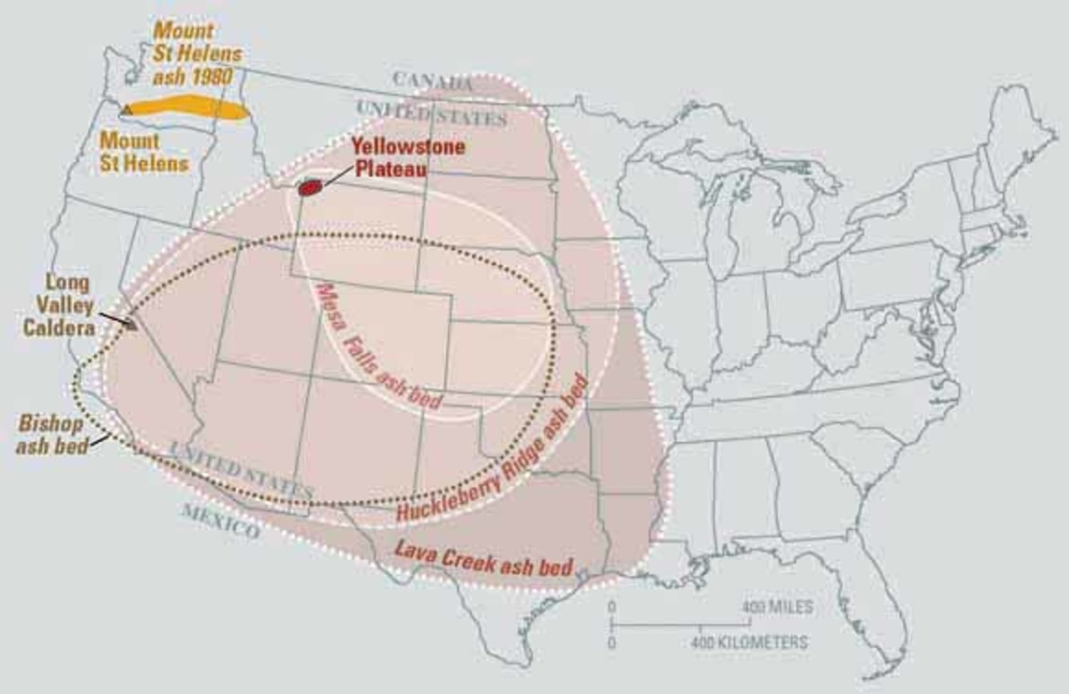
The Yellowstone Caldera is more than just a centerpiece of American natural beauty; it is one of the most complex geological puzzles on Earth. As a “supervolcano,” its potential for a high-magnitude eruption represents a “low-probability, high-consequence” event that could fundamentally alter the course of human civilization. While the geological timeline suggests we are not due for an eruption anytime soon, the question of “what if” provides a critical framework for evaluating our current technological capabilities. In the digital age, the response to such a cataclysmic event would not just be a matter of physical survival, but a massive deployment of cutting-edge technology, from predictive AI modeling to satellite-based remote sensing and decentralized infrastructure.
Predictive Analytics and AI: Modeling the Unthinkable
The first line of defense against a volcanic event of Yellowstone’s scale is not a physical barrier, but a digital one. In recent years, the field of volcanology has shifted from purely observational science to a data-driven discipline powered by artificial intelligence and machine learning.
Machine Learning in Seismology
Yellowstone is one of the most monitored places on the planet. Thousands of seismic events occur there every year, most of them too small to be felt by humans. Historically, distinguishing between “background noise” (thermal activity or minor tectonic shifts) and “precursory signals” (magma movement) was a manual, time-consuming process.
Today, AI algorithms are trained to recognize patterns in seismic waveforms that precede eruptions. By processing petabytes of historical data from volcanic sites worldwide, these tools can identify subtle anomalies that the human eye might miss. If Yellowstone were to show signs of an eruption, deep-learning models would be the first to flag the specific frequency shifts indicative of magma migrating toward the surface, providing crucial lead time for mitigation efforts.
Supercomputing and Atmospheric Simulation
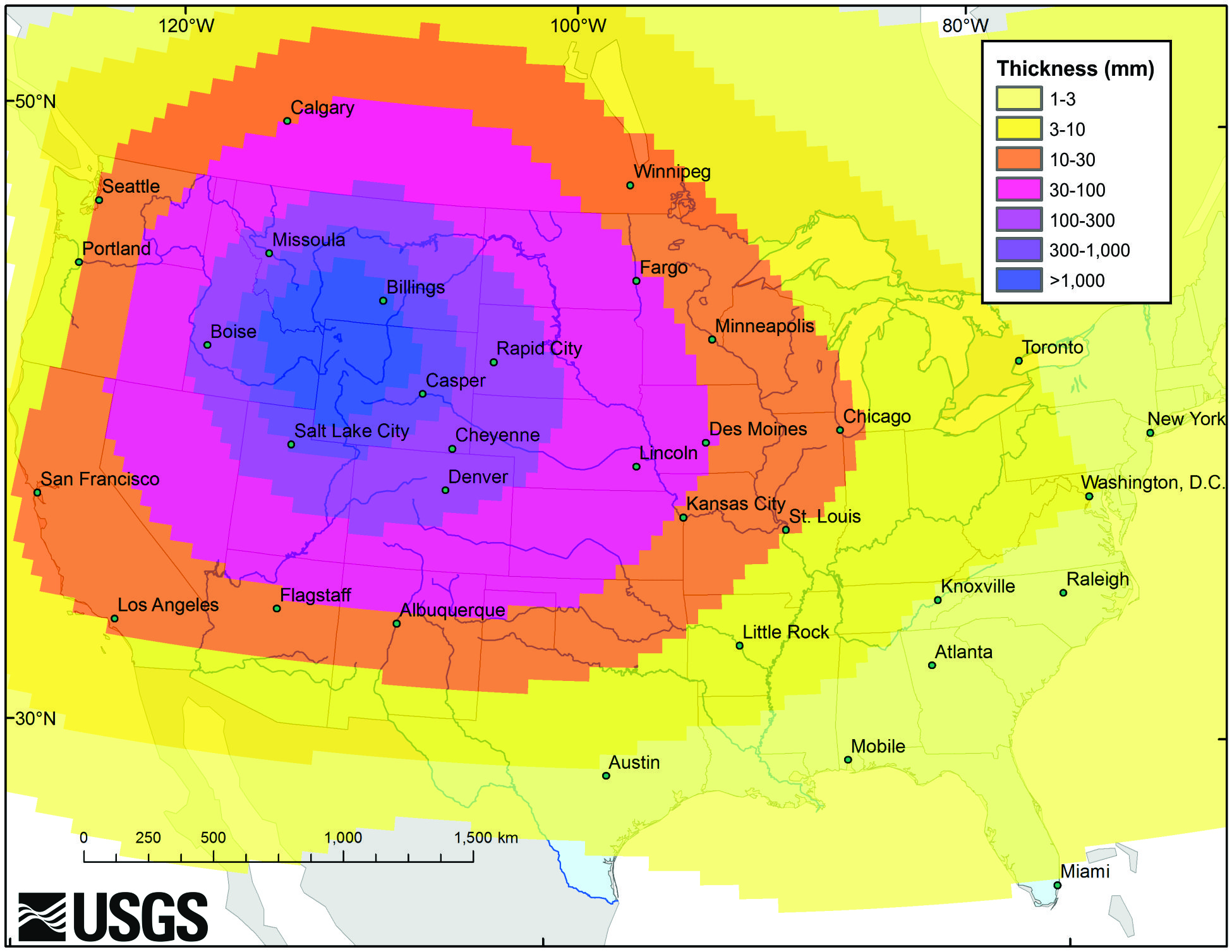
An eruption at Yellowstone would release an unimaginable volume of ash and sulfur dioxide into the atmosphere. The primary technological challenge is predicting where that ash will go. High-performance computing (HPC) clusters are now capable of running complex fluid dynamics simulations that account for real-time wind patterns, atmospheric pressure, and particle weight.
Modern software, such as the Ash3d model developed by the USGS, allows scientists to project ash fall across the continental United States within minutes of a detected event. These simulations are vital for the aviation industry, which relies on precise digital maps to reroute aircraft, as volcanic ash is lethal to jet engines. The integration of real-time weather data with volcanic modeling represents a pinnacle of modern predictive software.
The Role of Satellite Technology and Remote Sensing
If Yellowstone were to erupt, ground-based sensors might be destroyed or overwhelmed. This is where the orbital infrastructure—our “eyes in the sky”—becomes the primary source of intelligence. Satellite technology has revolutionized our ability to monitor the Earth’s crust without setting foot on the ground.
InSAR and Ground Deformation Monitoring
Interferometric Synthetic Aperture Radar (InSAR) is a specialized satellite technology that measures changes in the Earth’s surface with millimeter-level precision. By comparing radar images taken at different times, scientists can create “interferograms” that show if the ground is swelling or sinking.
In a Yellowstone eruption scenario, InSAR would be the primary tool for mapping the “inflation” of the caldera. Unlike traditional GPS stations, which provide data only for a single point, InSAR provides a comprehensive digital map of the entire region. This allows tech-driven response teams to identify the exact epicenter of pressure buildup, even if the area is obscured by smoke or clouds.
Thermal Imaging and Gas Detection
Modern satellites are equipped with multispectral sensors capable of detecting heat signatures and chemical compositions from space. Instruments like the Ozone Monitoring Instrument (OMI) and the Tropospheric Monitoring Instrument (TROPOMI) can track the release of sulfur dioxide (SO2) and carbon dioxide (CO2).
An increase in gas emissions is often a precursor to an eruption. In the event of an active plume, these satellite tools allow for the digital tracking of the “volcanic cloud” as it moves across the globe. This data is fed directly into global environmental monitoring apps and platforms, ensuring that governments and tech-dependent industries remain informed about air quality and visibility levels in real-time.
Resilience and Infrastructure Tech in a Volcanic Winter
The aftermath of a Yellowstone eruption is often described as a “volcanic winter,” where ash in the stratosphere reflects sunlight, leading to a drop in global temperatures. Surviving such a period requires a radical rethink of our technological infrastructure, specifically regarding energy, data, and food security.
Protecting Data Centers and Global Networks
Our modern world runs on silicon and fiber optics. Volcanic ash is not just “dust”; it is composed of jagged particles of rock and volcanic glass that are electrically conductive and highly abrasive. This poses a catastrophic threat to data centers, which require massive amounts of clean air for cooling.
The tech industry is already exploring “hardened” infrastructure solutions. This includes air filtration systems using HEPA and chemical scrubbers designed for extreme environments, as well as the move toward “liquid cooling” for servers. Liquid cooling eliminates the need for external air intake, creating a closed-loop system that can operate even in an ash-choked environment. Furthermore, the reliance on satellite internet constellations (like Starlink) ensures that global communication remains possible even if terrestrial fiber-optic cables are disrupted by ground shifts or volcanic mudflows (lahars).
Agricultural Tech: Indoor Farming and Synthetic Biology
A volcanic winter would disrupt traditional outdoor agriculture for years. To prevent a global food crisis, humanity would need to pivot to “AgTech” solutions. Vertical farming—growing crops in stacked layers within controlled environments—uses LED technology and hydroponics to bypass the need for sunlight and soil.
Furthermore, synthetic biology could be leveraged to engineer crops that are more resilient to low-light conditions and temperature fluctuations. These “resilience technologies” represent a shift from traditional farming to a tech-driven bio-manufacturing model, ensuring food security through software-controlled environments and genetic engineering.
Digital Governance and Communication Systems
In a crisis of this magnitude, the failure of communication is often as dangerous as the disaster itself. The “tech” of the 21st century provides new ways to maintain social order and manage resources when traditional systems are strained.
Decentralized Communication and Mesh Networks
One of the greatest vulnerabilities during a Yellowstone eruption would be the collapse of the central power grid and cellular towers. “Mesh networking” technology allows devices to connect directly to one another without a central hub. Using Bluetooth or Long Range (LoRa) radio waves, smartphones can create a decentralized web of communication. In an evacuation scenario, these peer-to-peer networks allow for the sharing of maps, medical data, and safety alerts even when the “internet” is technically down.
Blockchain for Resource Allocation
Distributing aid, food, and medicine during a global emergency requires immense transparency and efficiency. Blockchain technology, often associated with cryptocurrency, has profound applications in supply chain management. By using a decentralized ledger, international agencies can track the movement of critical resources in real-time, preventing hoarding and ensuring that supplies reach the areas of greatest need.
Smart contracts could automatically trigger the release of insurance payouts or emergency funds based on verified data from USGS or NASA sensors. This “automated governance” removes the bureaucratic bottlenecks that often delay disaster response, replacing them with a fast, transparent, and tech-driven distribution system.

The Future of Planetary Defense
The hypothetical eruption of Yellowstone serves as a stress test for the human species’ technological maturity. While we cannot stop a volcano from erupting, we are no longer the helpless observers our ancestors were. We now possess a digital “nervous system”—a global network of sensors, satellites, and AI—that can sense, analyze, and react to geological threats in ways that were science fiction just a few decades ago.
As we continue to advance in fields like quantum computing (which will allow for even more complex atmospheric modeling) and nanotechnology (which could provide new ways to filter ash or protect machinery), our ability to survive a Yellowstone-scale event improves. The intersection of Earth science and high technology is our best hope for resilience. By treating the Earth as a system that can be monitored and modeled, we move closer to a future where even the most violent natural phenomena can be managed through the power of human innovation and technological foresight.
aViewFromTheCave is a participant in the Amazon Services LLC Associates Program, an affiliate advertising program designed to provide a means for sites to earn advertising fees by advertising and linking to Amazon.com. Amazon, the Amazon logo, AmazonSupply, and the AmazonSupply logo are trademarks of Amazon.com, Inc. or its affiliates. As an Amazon Associate we earn affiliate commissions from qualifying purchases.