
In the evolving landscape of digital navigation, applications like Google Maps have transformed from simple map displays into sophisticated tools that offer real-time insights into road conditions, traffic, and even potential hazards. Among its myriad features, the ability to identify “speed traps” stands out as particularly intriguing for drivers. Far from being a mere static warning, a speed trap on Google Maps represents a dynamic, community-driven data point designed to enhance driver awareness and safety, firmly embedding itself within the realm of practical technology applications.
The Digital Evolution of Driver Awareness
Traditionally, avoiding a speed trap—a location where law enforcement monitors vehicle speeds, often covertly, to issue tickets—relied on local knowledge, word-of-mouth, or sheer luck. The advent of GPS navigation systems began to shift this paradigm, but it was the rise of interconnected, smart mobile applications that truly revolutionized driver awareness. Google Maps, a titan in the geospatial technology sector, harnesses its vast user base and sophisticated algorithms to provide real-time information that was previously unattainable.

Beyond Basic Navigation
Google Maps isn’t just about getting from point A to point B; it’s about optimizing the journey. This optimization extends beyond avoiding traffic jams to include alerting drivers to construction, accidents, and indeed, speed traps. This feature underscores a significant trend in tech: the move towards predictive and preventative information delivery. Instead of reacting to events, users are proactively informed, allowing them to adjust their driving behavior accordingly.
The Role of User-Generated Content
Central to the functionality of speed trap alerts in Google Maps is the concept of user-generated content (UGC). Unlike static points of interest, speed trap locations are transient and often unpredictable. Relying solely on official data would be impractical. Instead, Google Maps leverages its millions of active users as a vast network of real-time reporters. This crowdsourcing model is a hallmark of many successful digital platforms, turning individual observations into collective intelligence.
How Google Maps Processes Speed Trap Data
The mechanism by which Google Maps integrates and presents speed trap information is a sophisticated blend of crowdsourcing, data validation, and intuitive interface design. It’s a prime example of how big data and user engagement converge to create a valuable real-time service.
Crowdsourcing: The Eyes on the Road
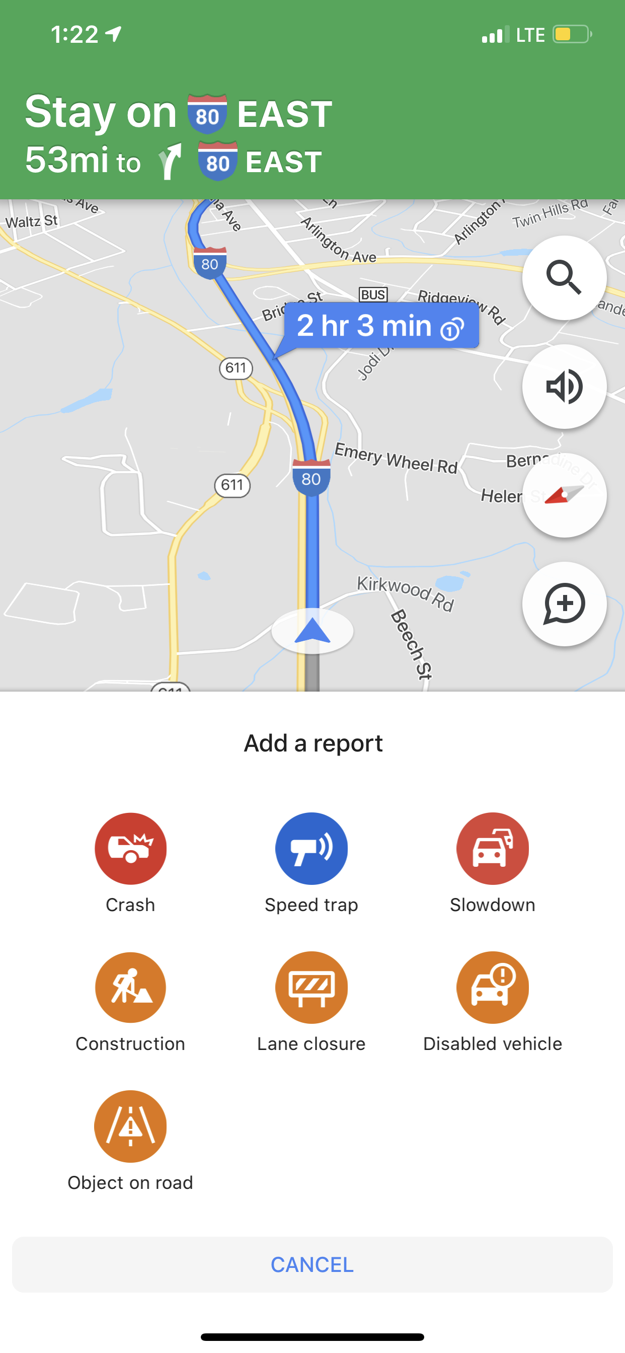
When a user encounters a speed trap, they have the option to report it directly within the Google Maps app. This process is typically streamlined and requires minimal interaction, ensuring drivers can report safely. Users can usually tap a button on the screen to indicate the presence of a speed trap, often alongside other road events like accidents or lane closures. This immediate reporting is crucial for data freshness.
Validation and Verification Algorithms
Given that speed trap data is user-generated, a critical component of Google Maps’ system is its validation process. Not every report is immediately treated as gospel. Google employs complex algorithms that weigh various factors to determine the credibility and accuracy of a report. These factors can include:
- Multiple Reports: A single report might be an anomaly, but multiple independent reports from different users in the same location within a short timeframe significantly increase the likelihood of a legitimate speed trap.
- User Reputation: While not explicitly detailed by Google, it’s common for crowdsourcing platforms to subtly (or explicitly) give more weight to reports from users who have a history of accurate contributions.
- Temporal Relevance: Speed traps are often temporary. Reports are time-stamped, and their validity diminishes over time, requiring continuous updates. The system intelligently removes older, unconfirmed reports.
- Geographic Clustering: Algorithms can analyze whether reports cluster logically, indicating a persistent monitoring point or a common area for enforcement.
Data Visualization and Alerting
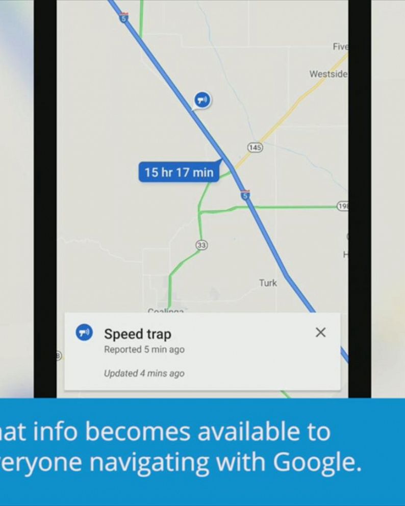
Once validated, the speed trap information is integrated into the navigation interface. Typically, it appears as an icon—often a camera or a police car symbol—on the map at the approximate location of the reported trap. If a driver is navigating towards or through an area with a reported speed trap, Google Maps may issue an audio alert, a visual notification on the screen, or both, well in advance. This proactive warning gives drivers ample time to check their speed and adjust their driving behavior.
Practical Application: Using Google Maps for Speed Trap Awareness
For the average user, leveraging Google Maps for speed trap awareness is straightforward. The feature is seamlessly integrated into the core navigation experience, making it an intuitive part of daily driving.
Activating and Observing Alerts
Generally, speed trap alerts are active by default when using Google Maps for navigation. Users don’t typically need to enable a specific setting. While navigating:
- Visual Cues: Look for small, distinctive icons (e.g., a police car, camera, or speed limit sign with a warning) directly on your map route. These icons denote reported speed traps or speed cameras.
- Audio Alerts: Google Maps may provide a verbal warning, such as “Speed trap reported ahead” or “Police ahead,” giving drivers an audible heads-up without needing to look at the screen. These alerts are crucial for maintaining focus on the road.
Reporting a Speed Trap
Users can actively contribute to the system by reporting speed traps they encounter:
- While navigating: Tap the report icon (often a speech bubble or a ‘+’ button) on the right side of the screen.
- Select “Speed trap” or “Police”: From the list of options (which may also include accident, slowdown, construction, etc.), choose the relevant option.
- Confirm: The report is sent, contributing to the collective data. This quick process minimizes distraction and encourages participation.
Understanding the Limitations
While incredibly useful, it’s important to understand that speed trap data, being crowdsourced, isn’t infallible.
- Accuracy: There might be instances of outdated reports or even mischievous ones. However, Google’s validation algorithms aim to mitigate these issues.
- Completeness: Not every speed trap will be reported. The system relies on user vigilance.
- Legal Compliance: The primary purpose of this feature is to inform and promote safe driving, allowing drivers to adhere to speed limits. It is not intended to encourage illegal driving practices or evasion of law enforcement.
The Technological Underpinnings: AI and Machine Learning
Beyond simple crowdsourcing, the efficacy of speed trap identification on Google Maps is increasingly bolstered by advanced technological concepts, particularly artificial intelligence (AI) and machine learning (ML). These technologies are pivotal in transforming raw user data into actionable intelligence.
Pattern Recognition and Predictive Analysis
ML algorithms can analyze vast datasets of past speed trap reports, traffic patterns, and even time-of-day data to identify areas where speed traps are historically common or likely to appear. For example, if a particular stretch of highway consistently sees reports on Friday evenings, the system can begin to weigh new reports from that area more heavily or even offer a predictive alert.
Dynamic Route Adjustments
While not directly changing routes solely for speed traps, the broader AI in Google Maps can factor in all available road information when suggesting optimal routes. If a route becomes significantly congested due to an accident and there are active speed trap reports, the AI considers the cumulative impact on travel time and driver experience.
Enhanced User Experience (UX)
AI also plays a role in refining the user experience. By understanding user interactions and feedback, the system can adapt how and when alerts are delivered, ensuring they are timely, relevant, and not overly intrusive. This continuous feedback loop helps in making the feature more effective and less distracting over time.
Ethical Considerations and Future Outlook in Tech
The integration of speed trap alerts into navigation apps like Google Maps sparks discussions about technology’s role in society, particularly concerning driver behavior and law enforcement. From a tech perspective, these conversations often revolve around data privacy, algorithmic bias, and the intended versus actual use of features.
Data Privacy and Anonymity
Google maintains that user reports are anonymized, protecting individual privacy. However, the aggregation of location data, even anonymized, always prompts discussions about data security and ethical data handling. Google’s commitment to user privacy in its location services is a constant area of development and scrutiny.
The Debate on Utility and Legality
The feature itself is generally considered legal, as it merely provides information that helps drivers comply with traffic laws. It encourages adherence to speed limits by making drivers aware of enforcement presence, thus promoting safer roads rather than encouraging speeding or lawbreaking. From a tech perspective, the challenge is to continuously refine the feature to serve this purpose ethically and effectively.
The Future of Real-Time Road Intelligence
Looking ahead, the capabilities of apps like Google Maps will likely continue to expand. We can anticipate:
- More Granular Data: As sensor technology in vehicles improves (e.g., connected car data), real-time reporting could become even more precise and automated.
- Predictive Policing Insights: While controversial, AI could potentially predict areas of higher enforcement based on historical data and real-time conditions, further enhancing driver awareness.
- Integrated Driver Assistance: Speed trap alerts could become seamlessly integrated into advanced driver-assistance systems (ADAS), providing warnings directly through a car’s dashboard or heads-up display.
In essence, a speed trap on Google Maps is more than just a pin on a digital map; it’s a testament to the power of connected technology, crowdsourced intelligence, and advanced algorithms working in concert to create a safer, more informed driving experience. It exemplifies how everyday technology continues to evolve, pushing the boundaries of what’s possible in real-time information delivery and driver assistance.
aViewFromTheCave is a participant in the Amazon Services LLC Associates Program, an affiliate advertising program designed to provide a means for sites to earn advertising fees by advertising and linking to Amazon.com. Amazon, the Amazon logo, AmazonSupply, and the AmazonSupply logo are trademarks of Amazon.com, Inc. or its affiliates. As an Amazon Associate we earn affiliate commissions from qualifying purchases.