
Understanding the Earth’s surface, its elevation, slope, and features, is fundamental to countless human endeavors. This intricate study is known as topography. In the modern era, the meaning of topography has evolved significantly, moving beyond traditional cartography to embrace a sophisticated array of digital technologies that allow for unprecedented precision, analysis, and application. Today, “what is meant by topography” is deeply intertwined with high-resolution sensors, advanced software, and powerful computing, defining how we interact with and reshape our physical world.
Decoding Earth’s Surface: A Digital Perspective
At its core, topography refers to the detailed mapping or description of the natural and artificial features of an area. This includes mountains, valleys, rivers, roads, and buildings, along with their relative positions and elevations. Traditionally, this was achieved through painstaking ground surveys and aerial photography, resulting in contour maps. However, the digital revolution has transformed how we perceive, capture, and utilize this information, redefining the very essence of topographical understanding.

The Fundamental Concept in a Data-Driven World
In a data-driven world, topography is less about static lines on paper and more about dynamic, three-dimensional datasets. It encompasses the geomorphology of the land—its shape and forms—but extends to the digital models that represent these features. These models are not just visual representations but robust datasets capable of complex spatial analysis. They provide the foundational layer for almost any activity that involves interaction with the physical environment, from constructing a skyscraper to deploying autonomous vehicles. The digital definition of topography emphasizes not just what the land looks like, but how its characteristics can be quantified, modeled, and simulated using technological tools.
From Physical Maps to Digital Elevation Models (DEMs)
The most significant technological shift in topography has been the transition from physical contour maps to Digital Elevation Models (DEMs). A DEM is a bare-earth raster grid of elevations, essentially a regularly spaced matrix of values where each cell represents a specific ground elevation. These models are generated using various techniques, including photogrammetry, satellite imagery, and LiDAR. They offer a continuous representation of the terrain, enabling much more sophisticated analysis than traditional contour lines. Variations like Digital Surface Models (DSMs) extend this concept by including the heights of features on the surface, such as buildings and vegetation, providing an even richer dataset for specific applications. These digital formats are the cornerstone of modern topographic analysis, feeding directly into Geographic Information Systems (GIS) and other specialized software.
Cutting-Edge Technologies for Topographic Data Acquisition
The accuracy and utility of modern topographic data hinge on the advanced technologies employed for its acquisition. These tools have drastically reduced the time and cost associated with mapping, while simultaneously boosting resolution and precision.
High-Resolution Satellite Imaging and Remote Sensing
Satellites equipped with sophisticated sensors are indispensable for large-scale topographic mapping. Remote sensing techniques allow for the collection of data across vast geographical areas, often in multiple spectral bands, providing insights beyond what the human eye can perceive. High-resolution optical satellites can capture imagery with ground sampling distances of less than 30 centimeters, enabling detailed visual and photogrammetric analysis. Synthetic Aperture Radar (SAR) satellites, on the other hand, can penetrate clouds and operate at night, making them invaluable for monitoring changes in terrain, especially in challenging environments or during disaster response. The processing of this satellite data, often involving advanced algorithms and machine learning, extracts elevation information to generate DEMs and monitor land cover changes with unprecedented regularity.
LiDAR (Light Detection and Ranging) for Precision Mapping
LiDAR technology has revolutionized the precision of topographic mapping. It works by emitting pulsed laser light and measuring the time it takes for the light to return to the sensor. By knowing the speed of light and the exact position and orientation of the sensor (typically mounted on aircraft, drones, or ground vehicles), extremely accurate 3D coordinates (point clouds) of the Earth’s surface are generated. LiDAR can penetrate dense vegetation to map the bare ground beneath, making it superior for applications requiring precise terrain models, such as hydrological modeling, forestry management, and urban planning. The resulting point clouds, often comprising billions of points, are then processed using specialized software to create highly detailed DEMs and 3D models of structures.
GPS and Advanced Surveying Systems
While large-scale data comes from aerial and orbital platforms, ground-based systems remain crucial for high-accuracy, localized topographic data collection. Global Positioning System (GPS) receivers, now enhanced with Real-Time Kinematic (RTK) and Post-Processed Kinematic (PPK) capabilities, provide centimeter-level accuracy for surveying specific points. Total stations, which combine electronic distance measurement with angular measurements, are still widely used for construction layouts, cadastral surveys, and precise monitoring of infrastructure. These ground truth points are often integrated with remote sensing data to improve overall accuracy and validate models, forming a hybrid approach that leverages the strengths of both methodologies.
UAVs (Drones) and Photogrammetry for Agile Data Collection
Unmanned Aerial Vehicles (UAVs), commonly known as drones, have emerged as a highly agile and cost-effective platform for topographic data acquisition over smaller to medium-sized areas. Equipped with high-resolution cameras, LiDAR sensors, or even multispectral sensors, drones can collect data rapidly and frequently. Photogrammetry, the science of making measurements from photographs, is extensively used with drone imagery. By taking overlapping images from multiple angles, specialized software can reconstruct a 3D model of the terrain and features, generating orthophotos (geometrically corrected aerial images) and DEMs with high spatial resolution. This technology is particularly beneficial for construction site monitoring, infrastructure inspection, small-scale mapping projects, and rapid response mapping during emergencies.
Geographic Information Systems (GIS): The Engine of Topographic Analysis
Once topographic data is acquired, it needs to be managed, analyzed, and visualized. This is where Geographic Information Systems (GIS) play a pivotal role, serving as the central hub for all spatial data.

Integrating Diverse Data Sources
GIS platforms are designed to integrate various types of geospatial data, including DEMs, satellite imagery, aerial photos, LiDAR point clouds, and ground survey points. This integration allows for a comprehensive understanding of an area, combining elevation data with land cover, infrastructure, population density, and other relevant information. By layering these datasets, users can perform complex queries and analyses that would be impossible with isolated data sources. The ability to manage vast quantities of heterogeneous data in a structured, accessible format is a core strength of modern GIS.
Advanced Spatial Modeling and Visualization
Beyond simple mapping, GIS enables advanced spatial modeling and visualization of topographic features. Users can derive various products from DEMs, such as slope maps (showing the steepness of terrain), aspect maps (showing the direction of slopes), hydrological flow paths, and viewshed analyses (identifying areas visible from a particular point). These analytical tools are critical for understanding natural processes, planning infrastructure, assessing environmental impacts, and simulating potential scenarios like flood inundation or landslide risk. High-fidelity 3D visualization capabilities within GIS allow for immersive exploration of terrain, aiding in decision-making and communication for stakeholders across various fields.
Transformative Applications Across Digital Ecosystems
The insights derived from modern topographic data fuel a multitude of applications across diverse digital ecosystems, impacting industries from urban development to environmental conservation.
Smart City Planning and Infrastructure Development
Accurate topographic data is fundamental for smart city initiatives. Urban planners use DEMs to model sunlight exposure for building design, analyze pedestrian flow, plan optimal routes for public transport, and manage stormwater runoff effectively. For infrastructure development, from roads and railways to utilities, precise elevation models are crucial for site selection, cut-and-fill calculations, and ensuring proper grading and drainage. Topographic data integrated into Building Information Modeling (BIM) workflows allows for better coordination between above-ground structures and the underlying terrain.
Environmental Management and Predictive Modeling
Topography plays a critical role in understanding natural systems. Hydrologists use DEMs to delineate watersheds, model water flow, and predict flood risks, informing early warning systems and mitigation strategies. Geologists rely on topographic analysis to identify fault lines, assess landslide potential, and study erosion patterns. Ecologists use elevation data to understand habitat distribution and species movement. Predictive modeling, often powered by AI and machine learning, leverages topographic data to simulate the impacts of climate change, deforestation, or urbanization on ecosystems.
Autonomous Systems and Robotics Navigation
The rise of autonomous vehicles, drones, and robotics heavily depends on precise topographic and terrain data. High-definition maps, which include detailed elevation information, are essential for self-driving cars to navigate complex urban environments, avoiding obstacles and predicting road conditions. Autonomous drones use 3D terrain models for path planning, obstacle avoidance during inspection, and precise payload delivery. Robots operating in industrial or environmental settings utilize localized topographic data to adapt to uneven surfaces and perform tasks safely and efficiently.
Precision Agriculture and Resource Optimization
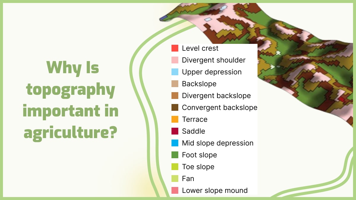
In agriculture, topographic data aids in optimizing land use and resource management. Farmers use precision elevation maps to identify areas prone to waterlogging or erosion, enabling targeted irrigation, drainage, and soil management strategies. This leads to more efficient use of water, fertilizers, and pesticides, reducing environmental impact and improving crop yields. For forestry, LiDAR-derived topographic models help in assessing timber volume, planning harvesting operations, and monitoring forest health, integrating into smart farming platforms and digital twin initiatives for agricultural landscapes.
The Evolving Frontier: AI, Machine Learning, and Real-time Topography
The future of topography is intrinsically linked with advancements in artificial intelligence, machine learning, and the pursuit of real-time data integration. These emerging technologies promise to further automate, refine, and dynamize our understanding of the Earth’s surface.
Automated Feature Extraction and Change Detection
AI and machine learning algorithms are increasingly being deployed to automate the extraction of features from raw topographic data. Neural networks can quickly identify and classify landforms, drainage networks, roads, and buildings from LiDAR point clouds or satellite imagery, significantly reducing the manual effort previously required. Furthermore, these intelligent systems excel at change detection, automatically identifying subtle alterations in topography over time, whether due to natural processes like erosion and landslides, or human activities such as construction and mining. This allows for continuous monitoring and rapid response to dynamic environmental conditions.
Predictive Analytics and Dynamic Terrain Modeling
Beyond detecting current states, AI-driven models are enabling advanced predictive analytics for topography. By integrating historical data, weather patterns, and geological information, algorithms can forecast potential terrain changes, such as areas susceptible to future landslides or erosion hotspots. The concept of “dynamic terrain modeling” involves creating continuously updated 3D models that reflect real-time changes on the ground, integrating data streams from various sensors. This capability is vital for applications requiring immediate environmental awareness, such as disaster management, military operations, and autonomous navigation in rapidly changing landscapes, painting a picture of an always-on, intelligent understanding of our planet’s surface.
aViewFromTheCave is a participant in the Amazon Services LLC Associates Program, an affiliate advertising program designed to provide a means for sites to earn advertising fees by advertising and linking to Amazon.com. Amazon, the Amazon logo, AmazonSupply, and the AmazonSupply logo are trademarks of Amazon.com, Inc. or its affiliates. As an Amazon Associate we earn affiliate commissions from qualifying purchases.