
In the intricate landscape of modern airspace management, safety and security are paramount. Among the various tools utilized by the Federal Aviation Administration (FAA) to manage these priorities, the Temporary Flight Restriction (TFR) stands out as a critical mechanism. For pilots, drone operators, and aviation enthusiasts alike, understanding the nature, purpose, and operational implications of a TFR is not merely a matter of regulatory compliance—it is a fundamental requirement for situational awareness and flight safety.
The Definition and Purpose of a TFR
At its core, a Temporary Flight Restriction (TFR) is a specific type of Notice to Air Missions (NOTAM) that defines an area of restricted airspace. When a TFR is active, the FAA restricts, limits, or prohibits aircraft from operating within a designated area for a set period. Unlike permanent airspace classifications, such as Class B or Class C airspace, TFRs are dynamic, fluid, and often short-lived, designed to address immediate or evolving situations.
Ensuring Public Safety and National Security
The primary objective behind issuing a TFR is the protection of persons and property, both in the air and on the ground. These restrictions are enacted under Title 14 of the Code of Federal Regulations (14 CFR) Section 91.137, which grants the FAA the authority to restrict flight in areas where there is a hazard to persons or property, or to manage national security interests.
By creating a “bubble” of restricted airspace, the FAA effectively removes civilian traffic from zones where high-risk activities are occurring. This separation is vital for de-conflicting general aviation, commercial flights, and specialized aerial operations, ensuring that the former does not inadvertently enter a zone where they could become a hazard or be placed in danger.
Scenarios Triggering TFR Implementation
The reasons for a TFR are as varied as the events that precipitate them. Generally, these fall into a few primary categories:
- National Security and Presidential Movements: High-profile TFRs are frequently issued for the movement of the President of the United States, the Vice President, or other high-ranking dignitaries. These protect against potential airborne threats in sensitive areas.
- Disaster Relief and Emergency Operations: During forest fires, hurricanes, or massive floods, TFRs are established to allow firefighting aircraft, medical helicopters, and search-and-rescue teams to operate without the risk of colliding with sightseers or unauthorized civilian aircraft.
- Large-Scale Public Events: Events that draw massive crowds—such as the Super Bowl, major political conventions, or large outdoor festivals—often have TFRs imposed to prevent aerial interference and mitigate security risks.
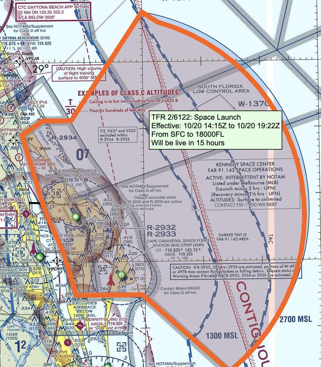
- Space Agency Operations: TFRs are commonly used during rocket launches (e.g., SpaceX or NASA missions) to ensure that aviation traffic remains clear of the trajectory and the landing zones for booster rockets.
The Operational Mechanics of TFRs
For an aviator, the existence of a TFR is not a suggestion; it is a legal directive. Ignorance of an active TFR is rarely accepted as a valid excuse by regulatory authorities, placing the onus of due diligence entirely on the pilot in command.
How Pilots Identify Active TFRs
The aviation industry relies on a robust dissemination system to ensure that TFR data is accessible to all stakeholders. The primary repository for this information is the FAA’s TFR website, which provides a graphical interface showing restricted areas on a map. However, simply checking this website before departure is often insufficient.
Pilots are required to utilize various pre-flight planning tools, such as ForeFlight, Garmin Pilot, or the official FAA NOTAM search system. These digital platforms ingest real-time data to provide pilots with visual overlays and textual descriptions of TFRs along their intended route. Because TFRs can be issued, modified, or canceled with very little notice, professional pilots make it a standard practice to check for NOTAMs immediately before engine start, and often monitor them periodically during long-duration flights.
Understanding the Geometry of Restrictions

A TFR is defined by its geographic dimensions and altitude limits. Some are simple circular “cylinders” of airspace, while others are complex, irregular polygons designed to fit the specific needs of the event. A TFR might prohibit flight from the surface up to 5,000 feet, or it might extend into higher flight levels depending on the risk factor.
It is crucial for pilots to read the specific “Notam text.” The text will specify:
- The Effective Times: When the restriction begins and ends (usually in Coordinated Universal Time, or UTC).
- The Geographic Coordinates: The center point and the radius in nautical miles.
- The Altitude Limits: The vertical extent of the TFR.
- Exceptions: Certain TFRs contain exceptions, such as permitting law enforcement aircraft, medical evacuations, or aircraft on an active instrument flight plan (IFP) communicating with Air Traffic Control (ATC).
Navigating the Legal and Safety Consequences
The violation of a TFR is a serious regulatory offense with tangible consequences. In the best-case scenario, an inadvertent violation results in a stern phone call from the FAA or a letter of investigation. In worse scenarios, it can lead to the suspension or revocation of a pilot’s certificate, significant monetary fines, or, in extreme cases of intentional penetration of sensitive security areas, criminal prosecution.
The Role of Technology in Compliance
Modern aviation technology has drastically reduced the likelihood of accidental TFR intrusion. GPS-enabled flight deck displays and Electronic Flight Bags (EFBs) now feature “geofencing” alerts. These systems can provide both audible and visual warnings when an aircraft is approaching the boundary of a restricted zone, acting as an essential layer of digital defense.
However, pilots are taught never to rely exclusively on automation. A software glitch, an outdated database, or a failure in the hardware can render these tools ineffective. Thus, the human factor remains the primary safety barrier. Pilots must maintain rigorous traditional navigation and situational awareness, using the technology as a supplement rather than a substitute for competent aeronautical decision-making.
The Intercept Experience
When a pilot violates a high-security TFR, the response is swift and uncompromising. North American Aerospace Defense Command (NORAD) monitors airspace continuously. Should a civilian aircraft breach a sensitive TFR, the FAA may initiate a “security intercept.”
This involves the scrambling of military fighter jets to escort the aircraft out of the restricted zone or force it to land at a designated facility. This is an extremely dangerous and high-stress situation for the civilian pilot, involving complex communication procedures on international guard frequencies. Understanding TFR boundaries is the only way to ensure that such an encounter—which can be both life-threatening and career-ending—never occurs.
Future Trends in Airspace Management
As the aviation sector evolves, the management of TFRs is undergoing its own technological transformation. The integration of Unmanned Aircraft Systems (UAS)—commonly known as drones—into the National Airspace System (NAS) has introduced new challenges for TFR enforcement.
The Impact of Drones
The rise of recreational and commercial drone usage means that thousands of operators who may not have traditional pilot training are now subject to the same airspace restrictions. The FAA has responded by creating digital tools like “B4UFLY” and Low Altitude Authorization and Notification Capability (LAANC). These tools allow drone operators to see TFRs and request real-time airspace authorization, bridging the gap between sophisticated manned aviation and the rapidly expanding world of remote pilot operations.

Automation and Dynamic Data
In the future, we can expect “dynamic airspace” to become even more granular. Rather than static, long-term TFRs, the FAA is moving toward systems that can project airspace closures in near real-time via data links directly to the aircraft’s cockpit display. This will allow for more efficient airspace management, reducing the burden on pilots while simultaneously increasing the precision of security perimeters.
Ultimately, the TFR serves as a testament to the balance between freedom of flight and the necessity of order. By understanding what a TFR is, how to interpret the associated NOTAMs, and why these restrictions are implemented, pilots contribute to a safer, more predictable, and more secure aviation environment for everyone. Vigilance is the price of admission to the skies, and the disciplined adherence to temporary restrictions is a fundamental aspect of the pilot’s professional responsibility.
aViewFromTheCave is a participant in the Amazon Services LLC Associates Program, an affiliate advertising program designed to provide a means for sites to earn advertising fees by advertising and linking to Amazon.com. Amazon, the Amazon logo, AmazonSupply, and the AmazonSupply logo are trademarks of Amazon.com, Inc. or its affiliates. As an Amazon Associate we earn affiliate commissions from qualifying purchases.