In the professional world of architecture, land development, and urban planning, a site plan is arguably the most critical document in a project’s lifecycle. While floor plans focus on the internal layout of a structure, a site plan provides the “big picture,” documenting the relationship between a building and the land it occupies. From a design and branding perspective, a site plan is the foundational map that dictates how a development interacts with its environment, manages flow, and adheres to aesthetic and functional requirements.
The Core Elements of a Site Plan
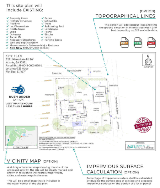
At its most fundamental level, a site plan is a bird’s-eye view—an overhead diagram that outlines the entire property boundary and every permanent fixture located within those lines. For developers and design firms, the site plan acts as the master narrative of the project. It is not merely a technical drawing; it is a communication tool that demonstrates how the project satisfies zoning requirements, environmental constraints, and user experience goals.
Property Boundaries and Setbacks
The skeleton of every site plan is the property survey. The plan must clearly delineate the legal boundaries of the parcel. Within these lines, designers must indicate “setbacks.” These are the mandatory distances from the property line to the structure, dictated by local zoning laws. A site plan demonstrates that the design respects these invisible borders, ensuring that the project remains compliant with municipal regulations.
Existing and Proposed Structures
The primary focus of the site plan is the footprint of the building itself. If the project involves an addition or a renovation, the site plan will differentiate between existing structures and new construction. This visual contrast is essential for stakeholders to understand the scale of the expansion. Every entrance, exit, and mechanical footprint must be mapped with precision to show how the building connects to the outside world.
Hardscape and Circulation Paths
A site plan does more than show buildings; it defines how people move through the space. Hardscape features—such as driveways, sidewalks, parking lots, and courtyards—are meticulously plotted. Designers use the site plan to optimize circulation. For a commercial brand, this means ensuring that pedestrian walkways are inviting and safe, while vehicle flow is intuitive and efficient. The placement of parking spaces, loading docks, and emergency access routes is verified here to ensure the “user journey” is seamless from the moment an individual enters the property.
The Visual Language of Land Development
Designers and developers approach site plans as part of the overall branding and functional strategy of a project. A cluttered or poorly rendered site plan can signal disorganization to planning committees or investors, whereas a clean, intentional site plan reinforces a brand’s commitment to quality and thoughtful design.
Topography and Grading
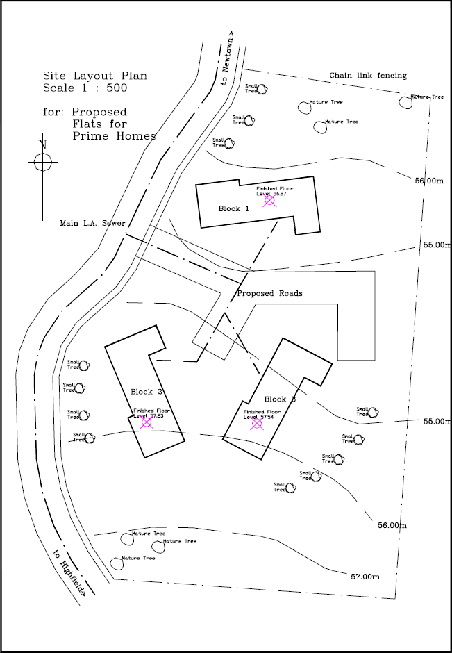
A sophisticated site plan incorporates topographical data. By using contour lines, planners show the natural slope of the land. This is where the engineering meets the aesthetic. Grading—the act of shaping the land to direct water drainage away from the foundation—must be carefully documented. In modern design, site plans often reflect sustainable practices, such as incorporating bioswales or rain gardens to manage stormwater runoff, which serves as a brand-building element for firms specializing in eco-conscious development.
Landscaping and Aesthetic Integration
The site plan is also the blueprint for the property’s “curb appeal.” It identifies where trees, shrubbery, and flower beds will be placed. In landscape architecture, this is not just about decoration; it is about creating microclimates, providing privacy, and enhancing the visual identity of the project. A well-designed site plan uses vegetation to soften the edges of hard structures, framing the building in a way that aligns with the client’s brand persona—whether that is a modern, minimalist tech campus or an organic, welcoming residential complex.
Utilities and Infrastructure Connections
Beyond what is visible to the eye, the site plan functions as a map for the unseen infrastructure. It charts the paths for water, sewage, electricity, and telecommunications. Identifying the points of connection to municipal lines is a critical step in the feasibility phase of any project. From a business perspective, clearly mapped infrastructure demonstrates that the project is “shovel-ready,” reducing perceived risk for investors and stakeholders.
Interpreting the Site Plan for Stakeholders
When presenting a site plan to clients, investors, or municipal boards, the document serves as the ultimate visual proof of a project’s viability. The way a site plan is presented—its clarity, scale, and attention to detail—directly impacts the professional reputation of the design firm.
Scale and Orientation
Accuracy is non-negotiable. A site plan must include a north arrow to establish orientation, which is crucial for understanding sun exposure and shadow patterns. Furthermore, a graphic scale ensures that viewers can accurately measure distances and proportions. If the scale is inconsistent or the orientation unclear, the entire project loses credibility. A professional site plan uses standard architectural symbols and a consistent legend, allowing anyone from a city inspector to a landscaping contractor to read the document without ambiguity.
Zoning Compliance and Regulatory Approval
A significant portion of a site plan’s purpose is to act as a regulatory checklist. In many jurisdictions, the site plan must be accompanied by a “zoning data table.” This table lists the required versus provided figures for building height, floor area ratio (FAR), lot coverage, and parking stalls. When a site plan is presented with this data clearly articulated, it streamlines the approval process. For a development company, a clean, compliant site plan is a strategic asset that minimizes delays in the permitting phase, ultimately saving time and money.
Future-Proofing the Design
Visionary developers use the site plan to look toward the future. A high-quality site plan includes provisions for potential expansion or flexibility in use. By mapping out future zones or infrastructure capacity on the initial site plan, firms can demonstrate long-term value. This strategic foresight acts as a powerful branding element, positioning the developer or architect as a partner who thinks about the long-term lifecycle of the asset rather than just the immediate construction phase.
The Evolution of the Digital Site Plan
The days of hand-drawn blueprints are largely in the past, replaced by sophisticated Building Information Modeling (BIM) and Computer-Aided Design (CAD) software. This technological shift has transformed the site plan from a static drawing into a dynamic, data-rich model.
Layering and Intelligent Data
Modern site plans are built in layers. A project manager can toggle between a utility layer, a vegetation layer, and a hardscape layer. This digital versatility allows for rapid iterations. If a client decides to shift a building’s footprint by ten feet, the site plan can be updated to automatically reflect the new setback measurements, parking capacity, and drainage impact. This agility is a significant competitive advantage in the design industry, as it allows for real-time collaboration between architects, engineers, and landscape designers.
The Role of 3D Visualization
While a traditional site plan is a 2D document, modern design workflows often overlay these plans with 3D renderings to provide a more immersive experience for stakeholders. Seeing the site plan translated into a 3D model allows clients to understand how the building sits in the context of the surrounding topography. It bridges the gap between technical requirements and artistic vision, ensuring that the final build matches the client’s brand expectations.
Ultimately, a site plan is the convergence of law, engineering, and design. It is the architectural document that anchors a building to the earth, proving that the structure is not only possible but also well-integrated into its surroundings. By meticulously planning the placement of every feature—from the smallest sidewalk light to the primary structure itself—designers create environments that are both functional and visually compelling, upholding the highest standards of professional development.