
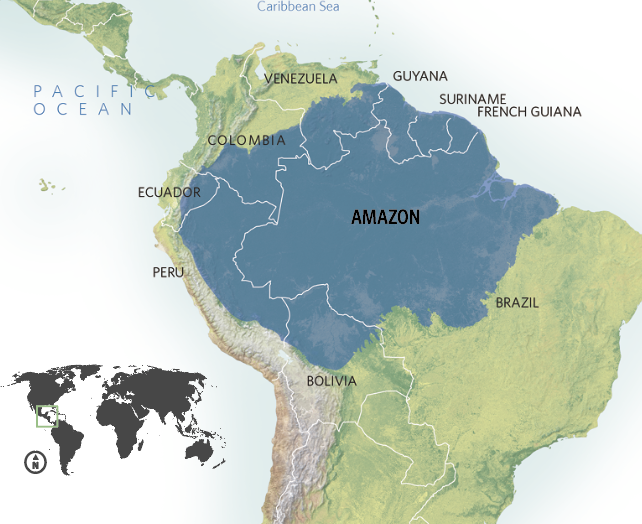
The Amazon Rainforest, an unparalleled biome of immense ecological significance, often evokes images of sprawling green canopies and winding rivers. But “where is the Amazon rainforest located?” is a question that, in the 21st century, extends far beyond simple geographic coordinates. It delves into the intricate web of digital cartography, satellite reconnaissance, artificial intelligence, and real-time monitoring tools that define our modern understanding and protection of this vital global asset. For tech enthusiasts and professionals, the Amazon is not just a place on a map; it’s a dynamic dataset, a challenge for advanced algorithms, and a testament to the power of technology in environmental stewardship.

Spanning across nine South American countries—Brazil, Peru, Colombia, Ecuador, Bolivia, Venezuela, Guyana, Suriname, and French Guiana—the Amazon’s vastness makes traditional mapping insufficient. Its approximate 6.7 million square kilometers represent a significant portion of Earth’s remaining primary rainforests. Pinpointing its exact, ever-shifting boundaries, monitoring its health, and identifying threats requires an arsenal of cutting-edge technological solutions. From the sophisticated orbital mechanics of Earth-observing satellites to the granular insights provided by ground-based sensors and AI-driven analytics, technology is redefining how we answer the fundamental question of “where” the Amazon is, and more importantly, “what state” it is in.
The Digital Cartography of Amazonia: Mapping the Unseen
Understanding the sheer scale and intricate geography of the Amazon is the foundational step in any conservation effort. Historically, this involved laborious expeditions and aerial surveys. Today, technology has transformed this process into a precise, dynamic, and often real-time endeavor, enabling an unprecedented level of detail and responsiveness.
Geographic Information Systems (GIS) and Satellite Reconnaissance
At the forefront of locating and analyzing the Amazon is the Geographic Information System (GIS). GIS platforms integrate, store, analyze, and display all forms of geographically referenced information. For the Amazon, this means layering data from countless sources: satellite imagery, topographical maps, river networks, national park boundaries, indigenous territories, and even data on human settlements and infrastructure projects. These digital maps are not static; they are living documents that can be updated continuously, providing a comprehensive spatial understanding of the region.
Satellite reconnaissance is the lifeblood of Amazonian GIS. Missions like NASA’s Landsat, the European Space Agency’s Sentinel, and commercial constellations provide continuous, high-resolution imagery of the entire basin. These satellites collect data across various spectral bands, allowing scientists to differentiate between healthy rainforest, deforested areas, agricultural land, water bodies, and even specific types of vegetation. Multispectral and hyperspectral imaging goes beyond what the human eye can see, detecting subtle changes in plant health, soil composition, and even the presence of hidden wildfires long before they become visible on the ground. This constant stream of data forms the backbone for tracking deforestation rates, monitoring river changes, and mapping previously uncharted areas.
Precision Mapping: From GPS to Hyperspectral Imaging
The ability to accurately pinpoint locations within the Amazon has also seen revolutionary advancements. While Global Positioning System (GPS) devices have become ubiquitous, their application in remote Amazonian regions is critical for field teams, researchers, and enforcement agents. GPS receivers allow on-the-ground validation of satellite data, mark critical conservation sites, and navigate complex terrain where traditional maps are often inadequate.
Beyond basic location, precision mapping now employs highly specialized technologies. Lidar (Light Detection and Ranging) technology, often deployed from aircraft or drones, uses pulsed laser light to measure distances to the Earth. This generates incredibly detailed 3D maps of the forest canopy and, crucially, the terrain beneath it. Lidar can penetrate dense foliage, revealing hidden rivers, ancient earthworks, and subtle changes in topography that are invisible from standard satellite views. This granular data is invaluable for understanding forest structure, biomass estimation, and hydrological modeling. Combining Lidar with hyperspectral imaging—which captures light from across the electromagnetic spectrum in hundreds of narrow bands—allows for unprecedented detail in identifying specific plant species, detecting disease outbreaks, and mapping mineral deposits, all without physically setting foot in every square kilometer of the vast rainforest.
AI and Big Data: Unraveling the Amazon’s Vastness
The sheer volume of data generated by satellite imagery, sensors, and field observations from the Amazon is astronomical. This “big data” would be unmanageable without the power of Artificial Intelligence (AI) and advanced analytics. AI is transforming how we process, interpret, and derive actionable insights from this deluge of information, turning raw data into intelligence.
Predictive Analytics for Ecosystem Dynamics
AI algorithms are increasingly being used to build predictive models for the Amazonian ecosystem. By feeding historical data on climate patterns, deforestation rates, land use changes, and socio-economic factors into machine learning models, researchers can forecast future trends with greater accuracy. For example, AI can predict which areas are most vulnerable to future deforestation based on proximity to roads, agricultural expansion, or logging concessions. These predictive insights enable conservation organizations and government agencies to allocate resources more effectively, targeting preventative measures where they are most needed rather than reacting to damage after it has occurred.
Furthermore, AI models can simulate the impact of various climate change scenarios on the Amazon, helping to understand potential shifts in biodiversity, water cycles, and carbon storage capacity. This involves complex ecological modeling, where AI processes vast quantities of environmental data to identify intricate relationships and feedback loops within the ecosystem. The ability to predict potential tipping points—like the transformation of parts of the rainforest into savanna—is crucial for global climate strategies.
Machine Learning for Biodiversity Monitoring and Threat Detection
One of the Amazon’s defining characteristics is its unparalleled biodiversity. Monitoring millions of species across such a vast area is an impossible task for humans alone. Machine learning, a subset of AI, is revolutionizing this field. Acoustic monitoring systems, deployed throughout the forest, capture the “soundscape” of the Amazon. AI algorithms can then analyze these recordings to identify specific animal calls (birds, mammals, amphibians, insects), track their movements, and even detect unusual sounds like chainsaws or gunshots, indicating illegal activities. This passive, non-invasive method provides invaluable data on species distribution and population health.
Similarly, computer vision algorithms are trained to analyze satellite and drone imagery to identify specific features. Beyond just detecting deforestation, AI can differentiate between various types of land use (e.g., cattle ranching vs. soy plantations), identify illegal mining operations, or even locate small, clandestine airstrips used for illicit activities. These algorithms can process images much faster and more consistently than human analysts, allowing for near real-time threat detection and rapid response. The use of neural networks to classify vast datasets of imagery helps to identify subtle patterns that might otherwise go unnoticed, providing a dynamic and evolving picture of the Amazon’s health and the threats it faces.
Real-time Surveillance: Tech Tools Against Deforestation and Illegal Activities
The urgency of protecting the Amazon demands real-time data and rapid response capabilities. Technology has moved beyond historical mapping to active, continuous surveillance, acting as the eyes and ears of conservation efforts on the ground and from orbit.

Drone Technology and Remote Sensors for Ground-Level Intelligence
While satellites provide a macro view, drones offer invaluable micro-level intelligence. Equipped with high-resolution cameras, thermal imaging, and multispectral sensors, drones can survey specific areas with incredible detail and flexibility. They are deployed to monitor protected areas, track illegal logging trucks, identify poaching activities, and assess the impact of wildfires. Drones can access remote and dangerous terrains, providing critical information to rangers and law enforcement without risking human lives. Their ability to cover large areas quickly and discreetly makes them an essential tool for local enforcement and indigenous communities protecting their territories.
Complementing drones are networks of ground-based remote sensors. These IoT (Internet of Things) devices can measure environmental parameters like temperature, humidity, rainfall, and even seismic activity. Acoustic sensors, as mentioned, detect sounds of chainsaws or vehicles. These sensors transmit data in real-time via satellite or cellular networks, providing early warnings of disturbances or environmental changes. Coupled with AI, these sensor networks can learn normal patterns and flag anomalies, prompting immediate investigation.
Early Warning Systems: Leveraging Satellite Data and AI Algorithms
Perhaps one of the most impactful technological advancements for the Amazon is the development of early warning systems for deforestation. Programs like Brazil’s DETER (Detection of Deforestation in Real Time) and the University of Maryland’s GLAD (Global Land Analysis & Discovery) alerts use high-frequency satellite imagery (e.g., from Sentinel-1 and -2, or Planet Labs’ constellations) and AI algorithms to detect forest loss as it happens.
These systems analyze new satellite images daily or weekly, comparing them to previous baselines. When significant changes in forest cover are detected, automated alerts are sent out to government agencies, conservation groups, and indigenous communities. These alerts specify the exact location, size, and type of deforestation, allowing for rapid deployment of enforcement teams to intervene before extensive damage occurs. The effectiveness of these systems lies in their speed and accuracy, transforming reactive conservation into proactive intervention. The integration of AI helps to reduce false positives and refine the detection process, making these warnings increasingly reliable and actionable.
Empowering Conservation: From Citizen Science to Blockchain Solutions
Technology’s role in the Amazon extends beyond mapping and monitoring; it actively empowers individuals and organizations to participate in conservation and ensures greater transparency and accountability.
Mobile Applications and Crowd-Sourced Data for Environmental Action
The ubiquitous nature of smartphones has opened new avenues for citizen science and community-led conservation in the Amazon. Mobile applications allow local communities, indigenous peoples, and tourists to collect and share valuable data from the ground. Users can log observations of wildlife, report instances of illegal logging or mining, document pollution, or track environmental changes. These geo-tagged observations, often accompanied by photos or videos, feed into larger databases, complementing satellite data and providing a crucial human perspective. This crowd-sourced data empowers local populations to be frontline defenders of the rainforest, providing actionable intelligence to conservation groups and fostering a sense of ownership and responsibility. Apps can also provide educational resources, helping communities understand local biodiversity and sustainable practices.
Blockchain for Transparency in Sustainable Supply Chains
The global demand for products sourced from the Amazon, such as timber, minerals, and agricultural goods, often drives deforestation and illegal activities. Blockchain technology offers a powerful solution to this challenge by ensuring transparency and traceability throughout supply chains. By creating an immutable, distributed ledger, blockchain can track products from their point of origin in the Amazon to their final consumer.
For example, sustainable timber certified by a blockchain system would have every step of its journey—from felling to milling, transportation, and sale—recorded on the ledger. This makes it virtually impossible for illegally sourced timber to enter the supply chain undetected, as its provenance would not match the blockchain record. The same principle applies to products like coffee, cacao, or minerals. This technology provides consumers with verifiable assurance that the products they buy are ethically and sustainably sourced, thereby incentivizing responsible production and discouraging illegal practices that harm the Amazon. Smart contracts on the blockchain can further automate compliance and payment, streamlining transactions for certified sustainable producers.
The Future of Amazonian Protection: Emerging Technologies on the Horizon
As environmental challenges in the Amazon intensify, so too does the pace of technological innovation aimed at its protection. The next generation of tech solutions promises even more sophisticated tools for understanding, modeling, and safeguarding this critical ecosystem.
Quantum Computing and Advanced Climate Modeling
The complexity of the Amazonian ecosystem, its interactions with global climate systems, and the myriad factors influencing its future are almost beyond the computational capabilities of even today’s supercomputers. Quantum computing, with its potential to process vast amounts of data and solve complex optimization problems at unprecedented speeds, could revolutionize climate modeling. Quantum algorithms could create more accurate and dynamic simulations of the Amazon’s climate patterns, hydrological cycles, and carbon sequestration capabilities, providing deeper insights into its resilience and vulnerability. This could lead to more precise predictions of climate change impacts and more effective strategies for mitigation and adaptation. Simulating highly complex biochemical processes and their large-scale environmental effects could unlock entirely new approaches to understanding the rainforest’s intricate life systems.
Biotech Innovations for Restoration and Resilience
Beyond monitoring and protection, technology is also looking towards restoration. Biotechnology holds immense promise for healing degraded Amazonian landscapes and enhancing the rainforest’s natural resilience. Advances in genetic sequencing and synthetic biology could lead to the development of plant species better adapted to changing environmental conditions, or to methods for rapidly restoring soil fertility in deforested areas. For instance, understanding the genetics of highly resilient native species could inform restoration projects, allowing for the strategic reintroduction of robust flora.
Furthermore, emerging fields like biomimicry—where technological solutions are inspired by nature—could lead to innovative designs for sustainable infrastructure in the Amazon that work in harmony with the environment rather than against it. From self-healing materials to energy-efficient bio-inspired sensors, the future of Amazonian protection may increasingly involve technology that learns directly from the rainforest itself, ensuring its location on the global map remains vibrant and ecologically rich for generations to come.
In conclusion, “where is the Amazon rainforest located?” is a question no longer solely for geographers. It is a clarion call for technologists, engineers, data scientists, and innovators to deploy the most advanced tools at our disposal. From the satellites orbiting hundreds of kilometers above to the AI algorithms sifting through petabytes of data, technology provides the eyes, the intelligence, and increasingly, the solutions needed to understand, protect, and restore Earth’s most vital green lung. The ongoing battle for the Amazon is as much a technological frontier as it is an environmental one, demonstrating humanity’s capacity to leverage innovation for planetary well-being.
aViewFromTheCave is a participant in the Amazon Services LLC Associates Program, an affiliate advertising program designed to provide a means for sites to earn advertising fees by advertising and linking to Amazon.com. Amazon, the Amazon logo, AmazonSupply, and the AmazonSupply logo are trademarks of Amazon.com, Inc. or its affiliates. As an Amazon Associate we earn affiliate commissions from qualifying purchases.