
The hum of an engine, a distant contrail streaking across the azure, or the sheer presence of a massive metal bird gliding silently overhead – these sights often ignite a primal curiosity within us. “What airplane is that?” we wonder, craning our necks skyward. In an era where information is at our fingertips, this question is no longer a rhetorical musing but an answerable query, thanks to an array of sophisticated technologies. From casual observers to dedicated aviation enthusiasts, technology has democratized access to real-time flight data, transforming our relationship with the aerial ballet unfolding above us. This article delves into the technological marvels that empower us to identify, track, and understand the aircraft traversing our skies.

The Curious Case of the Overhead Aircraft: Why We Want to Know
The impulse to identify an aircraft is deeply rooted, combining elements of human curiosity, a fascination with engineering, and an appreciation for the vastness of our interconnected world. Before the digital age, identifying a plane involved specialized knowledge, a good pair of binoculars, and perhaps a copy of Jane’s All the World’s Aircraft. Today, the process is streamlined, immediate, and remarkably precise.
From Ancient Curiosity to Modern Data
For centuries, the sky was a realm of mystery and wonder. The first successful flights only amplified this fascination, but accurate identification remained a challenge, primarily confined to military or industry experts. The commercialization of air travel and the increasing volume of flights transformed the skies into bustling highways. Yet, for the average person on the ground, each passing aircraft remained an enigma until the advent of powerful, accessible technologies. This shift represents a profound democratization of information, allowing anyone with a smartphone to become an amateur air traffic controller, satisfying that inherent desire to connect with the intricate world above.
The Allure of Aviation and Real-Time Information
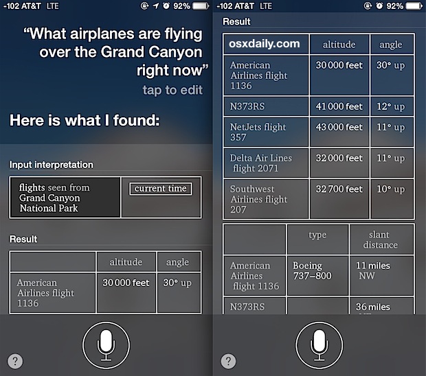
Beyond mere identification, the ability to track an airplane in real-time taps into several psychological drivers. For some, it’s about connecting with loved ones on a journey, watching their flight path as they cross continents. For others, it’s the sheer marvel of modern aviation – understanding the mechanics, the routes, and the scale of global air travel. Aviation enthusiasts find endless joy in pinpointing rare aircraft, tracking specific airlines, or observing flight patterns around major airports. This real-time, dynamic data transforms a static observation into an engaging, interactive experience, fostering a deeper appreciation for the complex ecosystem of modern flight. The ability to instantly pull up details about an aircraft – its origin, destination, type, speed, and altitude – adds layers of context that profoundly enrich the observation.
Essential Tech Tools for Real-Time Aircraft Identification
The primary revolution in aircraft identification stems from the proliferation of dedicated applications and web platforms that aggregate and visualize vast amounts of flight data. These tools leverage a combination of global sensor networks and internet connectivity to deliver insights directly to your device.
Flight Tracking Apps: Your Pocket-Sized Air Traffic Control
The smartphone has become the quintessential tool for identifying aircraft. A suite of highly sophisticated applications has emerged, turning your mobile device into a powerful flight tracker, radar, and information hub.
How They Work: Decoding ADS-B and Radar Data
At the heart of most modern flight tracking apps is a technology called Automatic Dependent Surveillance-Broadcast (ADS-B). This system allows aircraft to broadcast their position, altitude, speed, heading, and other data information to ground stations and other aircraft. Unlike traditional radar, which actively “pings” an aircraft, ADS-B is a passive system where aircraft continuously transmit their GPS-derived location data. A global network of ADS-B receivers, often operated by enthusiasts and organizations, collects this data and feeds it into central servers. These servers then process and distribute the information to the apps and websites we use. For areas not fully covered by ADS-B, or for older aircraft that don’t transmit ADS-B data, apps may integrate traditional radar data or use Multilateration (MLAT), which calculates an aircraft’s position by measuring the time difference of arrival of a signal at multiple ground stations.
Top Apps and Their Unique Features
Several apps dominate the flight tracking landscape, each offering a slightly different user experience and feature set:
- FlightAware: One of the most popular and comprehensive platforms, FlightAware offers real-time flight tracking, historical data, flight statistics, and predictive capabilities. It’s widely used by both enthusiasts and professionals in the aviation industry. Its interface is robust, providing detailed flight plans, aircraft specifications, and even estimated arrival times with high accuracy.
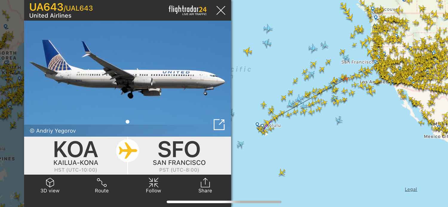
- FlightRadar24: Known for its slick, intuitive interface and impressive global coverage, FlightRadar24 is a favorite for many. Its map-based display is easy to navigate, allowing users to tap on any aircraft to pull up a wealth of information, including photos, speed, altitude, route, and origin/destination. It also boasts an augmented reality feature.
- Plane Finder: Another strong contender, Plane Finder offers similar real-time tracking capabilities with a clean design. It often highlights military and private jet movements more prominently, appealing to users interested in a wider variety of aerial traffic. It also offers advanced filtering options.
- ADS-B Exchange: While perhaps less polished than the commercial apps, ADS-B Exchange is celebrated by privacy advocates and enthusiasts for its unfiltered data. It often displays flights that commercial trackers might omit (e.g., certain military or private aircraft at owners’ request). Its raw data feed is invaluable for serious researchers and hobbyists.
Leveraging Augmented Reality for Instant Identification
Many leading flight tracking apps, notably FlightRadar24 and Plane Finder, incorporate an augmented reality (AR) feature. By simply pointing your phone’s camera at the sky, the app overlays real-time flight information directly onto your camera’s view. This innovative technology uses your phone’s GPS, compass, and accelerometer to determine which aircraft you’re looking at and then projects its flight number, airline, aircraft type, and sometimes even a photo, right on your screen. It’s an incredibly intuitive and engaging way to identify planes overhead, bridging the gap between the physical world and digital data.
Web-Based Platforms: Accessibility Without Installation
For those who prefer not to download an app or are working from a desktop computer, web-based flight tracking platforms offer nearly identical functionality. Websites like FlightAware.com, FlightRadar24.com, and PlaneFinder.net provide full-featured, interactive maps accessible through any modern web browser.
Browser-Based Tracking: Advantages and Limitations
The main advantage of web-based tracking is accessibility – no installation is required, and the service can be accessed from any internet-connected device. This is particularly useful for quick lookups or for users who frequently switch between devices. These platforms often provide a larger screen real estate, which can be beneficial for viewing dense air traffic or long flight paths. However, web versions may sometimes lack the seamless integration with device sensors (like AR features) that dedicated apps offer, and their responsiveness might be slightly dependent on browser performance and internet speed compared to a native application. Nevertheless, they remain an incredibly powerful and convenient way to tap into the global flight tracking network.
Diving Deeper: The Underpinnings of Flight Tracking Technology
Understanding the fundamental technologies at play enhances appreciation for the sophistication behind these seemingly simple tracking tools. It’s a testament to global collaboration and engineering ingenuity.
Automatic Dependent Surveillance-Broadcast (ADS-B): The Backbone of Modern Tracking
ADS-B is undeniably the cornerstone of modern flight tracking. It’s a critical component of the next-generation air traffic control systems being implemented worldwide.
How Aircraft Transmit Data
Every ADS-B equipped aircraft carries a transponder that automatically broadcasts a wealth of information: its precise position (derived from GPS), altitude, speed, unique identification code (ICAO 24-bit address), flight number, and sometimes even predicted path. These broadcasts occur several times per second on a specific radio frequency (1090 MHz or 978 MHz in the U.S.). This self-reporting system is a significant improvement over traditional radar, which relies on ground stations sending out pulses and receiving reflections.
The Global Network of Receivers
The data broadcast by aircraft is picked up by a vast, distributed network of ADS-B receivers on the ground. These receivers are relatively inexpensive and often built by enthusiasts using off-the-shelf components like Raspberry Pi microcomputers and SDR (Software Defined Radio) dongles. Thousands of these receivers, scattered across continents, feed their collected data to central aggregators like FlightAware and FlightRadar24. This crowdsourced data collection model is incredibly effective, providing broad coverage and redundancy, especially in remote areas or over oceans where traditional radar coverage is sparse. The more receivers contributing data, the more accurate and comprehensive the global flight map becomes.
Complementary Systems: Radar and Multilateration (MLAT)
While ADS-B is dominant, other technologies fill the gaps or provide additional layers of data.
- Radar: Traditional air traffic control radar systems still play a vital role, particularly for older aircraft not equipped with ADS-B, or as a backup. Radar works by sending out radio waves and measuring the time it takes for them to bounce back from an aircraft, determining its range and bearing. This data is also fed into flight tracking systems, albeit often with a slight delay compared to ADS-B.
- Multilateration (MLAT): For aircraft that don’t transmit ADS-B but do have an older Mode S transponder (which replies to ground interrogations), MLAT can be used. By precisely measuring the time difference of arrival (TDOA) of these transponder replies at multiple geographically dispersed ground receivers, an aircraft’s position can be calculated. MLAT is particularly effective for tracking aircraft at lower altitudes where line-of-sight to ADS-B receivers might be obstructed, or for planes that are only equipped with older transponders.
Data Aggregation and Visualization: Turning Raw Signals into Insight
The raw ADS-B, radar, and MLAT data is a chaotic stream of numbers and signals. The magic of flight tracking lies in the sophisticated backend systems that aggregate, process, filter, and visualize this immense dataset. High-performance servers ingest data from thousands of receivers globally, correlating it with known flight plans, airline schedules, and aircraft databases. Algorithms predict flight paths, estimate arrival times, and flag anomalies. This processed information is then rendered onto interactive maps using geospatial technologies, providing the intuitive, real-time views we see on our screens. The challenge is immense, involving Big Data analytics, real-time processing, and robust network infrastructure to handle the continuous flow of millions of data points every second.
Beyond Simple Identification: Advanced Use Cases and DIY Solutions
The utility of flight tracking technology extends far beyond satisfying casual curiosity. It underpins critical safety functions, enhances operational efficiency, and empowers a dedicated community of aviation enthusiasts and researchers.
Setting Up Your Own ADS-B Receiver: The Enthusiast’s Edge
For those truly captivated by aviation, the ultimate step is often to set up a personal ADS-B receiver. This is a rewarding project that offers an unparalleled level of insight and control.
Hardware and Software: Raspberry Pi and Beyond
The typical setup for a home ADS-B receiver involves a low-cost, credit-card-sized computer like a Raspberry Pi, an SDR (Software Defined Radio) USB dongle (which acts as the radio receiver), and a specialized antenna. Software like dump1090 (and its various forks) runs on the Raspberry Pi, decoding the ADS-B signals. Enthusiasts often enhance their setups with high-gain antennas, low-noise amplifiers (LNAs), and filters to improve signal reception range and quality. While Raspberry Pi is the most common, other single-board computers or even dedicated ADS-B receivers (like the FlightAware FlightFeeder or FlightRadar24’s own hardware) are also popular choices.
Contributing to the Global Flight Tracking Network
A significant motivation for setting up a personal ADS-B receiver is the ability to contribute data to the major flight tracking platforms. By feeding your collected data to FlightAware, FlightRadar24, or ADS-B Exchange, you become an active participant in the global network. In return, these platforms often provide premium access to their services, detailed statistics on your receiver’s performance, and the satisfaction of knowing you are helping to build a more comprehensive and accurate picture of global air traffic. This crowdsourced model highlights the power of community in advancing technological capabilities.
Broader Applications: Aviation Safety, Efficiency, and Research
The data gathered by flight tracking systems has profound implications beyond simple identification:
- Aviation Safety: Air traffic controllers use this data to monitor flights, prevent collisions, and guide aircraft safely. In emergencies, precise real-time location data is invaluable for search and rescue operations. Post-incident analysis often relies heavily on historical flight data.
- Operational Efficiency: Airlines use flight tracking to monitor their fleets, optimize routes, manage delays, and predict arrival times. Airport operators use it to manage ground movements, gate assignments, and resource allocation, leading to more efficient operations and reduced fuel consumption.
- Research and Analysis: Academics and researchers utilize flight data to study air traffic patterns, environmental impacts (noise, emissions), airspace capacity, and the effectiveness of air traffic management protocols. Journalists and investigators use it to track flights of interest, verify claims, and uncover aviation-related stories.
The Future of Aerial Identification: What’s Next?
The evolution of flight tracking technology is continuous, driven by advancements in connectivity, processing power, and user experience. The future promises even greater fidelity, integration, and expanded applications.
Enhancements in Data Fidelity and Predictive Analytics
Expect continued improvements in the accuracy and richness of flight data. Better receiver networks, more sophisticated signal processing, and the proliferation of newer aircraft equipped with advanced sensors will lead to even more precise real-time tracking. Predictive analytics will become even more nuanced, offering highly accurate forecasts for flight delays, arrival times, and even potential air traffic congestion, moving beyond current probabilistic models to more deterministic ones based on real-time operational factors.
Integration with Smart Devices and IoT
Flight tracking capabilities are likely to become more seamlessly integrated into our broader digital lives. Imagine smart home devices providing ambient updates on a loved one’s flight, or smartwatches delivering notifications as a specific aircraft approaches your location. Integration with Augmented Reality glasses or other wearables could offer hands-free, heads-up displays of flight information, making aerial identification even more effortless and immersive. The Internet of Things (IoT) will facilitate more pervasive data collection, possibly from sensors on buildings or even drones, further enhancing coverage and detail.
Addressing Privacy and Security in an Increasingly Tracked Sky
As flight tracking technology becomes more powerful and ubiquitous, conversations around privacy and security will naturally intensify. While most commercial flights are public information, the tracking of private and military aircraft raises questions about who has access to what data and under what circumstances. The industry will need to navigate the delicate balance between transparency for public benefit (safety, curiosity) and the legitimate need for privacy in certain contexts. Cybersecurity measures will also need to evolve to protect the integrity of the tracking networks and the vast amounts of data they handle, ensuring that the skies remain both open and secure.
In conclusion, the simple question, “What airplane is above me?” has opened the door to a fascinating world of technological innovation. From dedicated apps leveraging global sensor networks to the underlying ADS-B protocol and the passionate community of DIY enthusiasts, we are more connected to the skies above than ever before. As technology continues to advance, our ability to understand, track, and interact with the aerial domain will only deepen, offering new insights and expanding our appreciation for the marvels of modern aviation.
aViewFromTheCave is a participant in the Amazon Services LLC Associates Program, an affiliate advertising program designed to provide a means for sites to earn advertising fees by advertising and linking to Amazon.com. Amazon, the Amazon logo, AmazonSupply, and the AmazonSupply logo are trademarks of Amazon.com, Inc. or its affiliates. As an Amazon Associate we earn affiliate commissions from qualifying purchases.