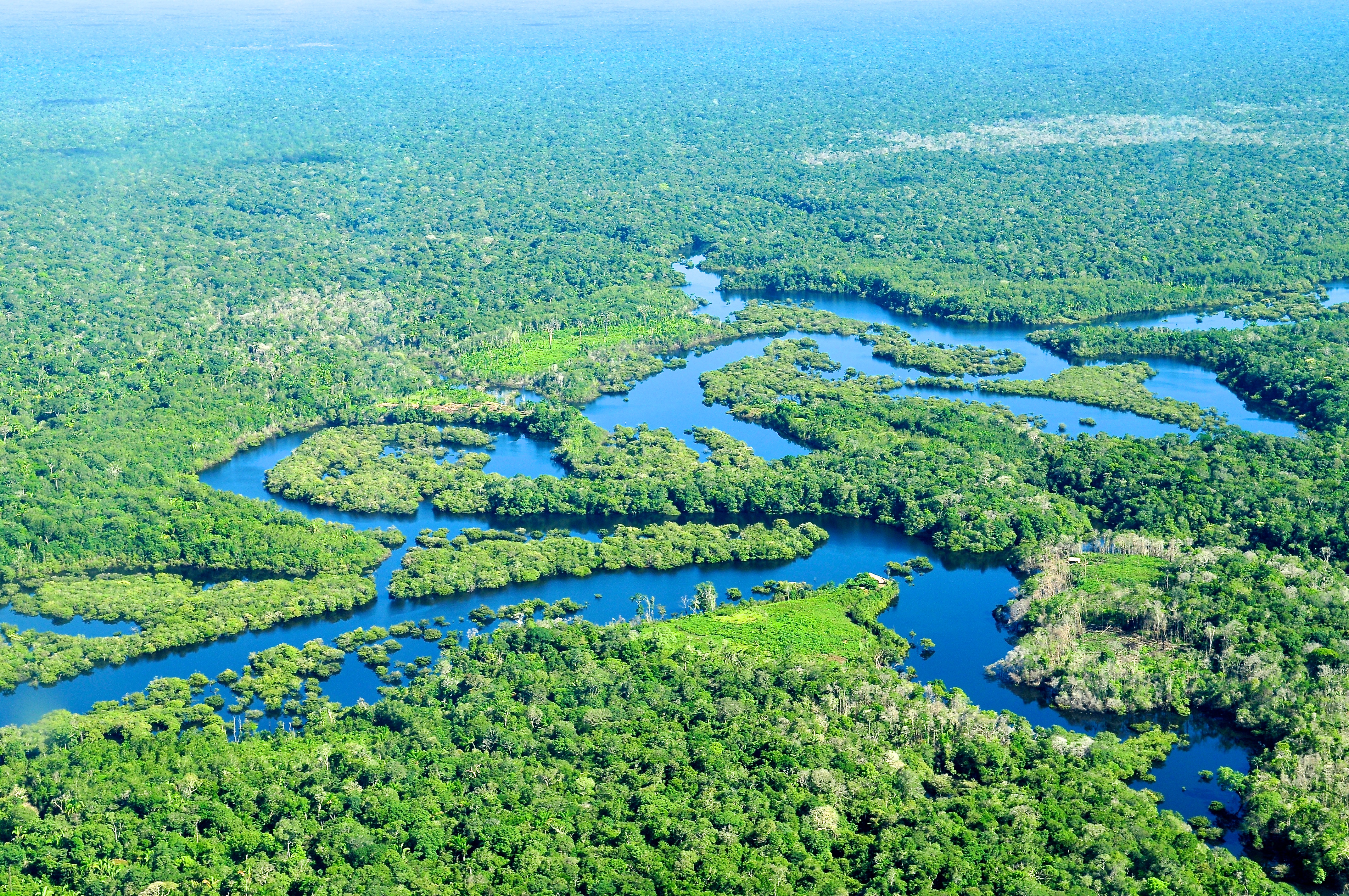
The Amazon rainforest, a colossal and irreplaceable biome, captures global attention not just for its unparalleled biodiversity and critical role in climate regulation, but also for the complex challenges surrounding its preservation. While the simple answer to “where is the Amazon forest located?” points to South America, the true depth of its location, its dynamic boundaries, and its current state can only be fully appreciated and managed through the lens of advanced technology. In an era defined by data and digital tools, understanding the Amazon’s presence—both geographically and ecologically—has become an intricate dance between on-the-ground observation and cutting-edge geospatial, AI, and monitoring technologies. This article delves into how technology doesn’t just help us locate the Amazon, but also understand, protect, and advocate for this vital natural treasure.
Mapping the Green Lungs: The Precision of Geospatial Technology
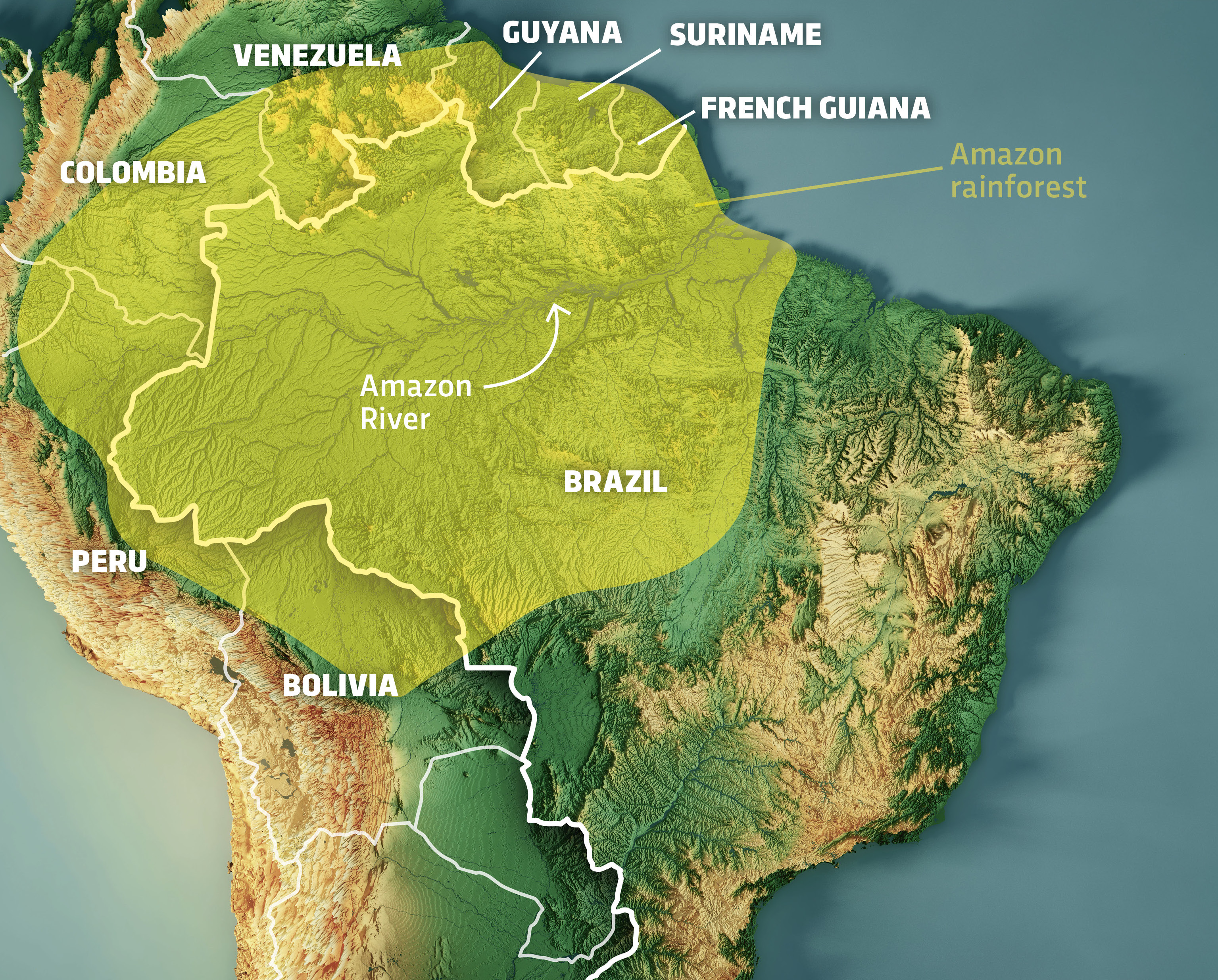
Pinpointing the Amazon rainforest is far more intricate than drawing a simple circle on a map. Its vastness, stretching across nine South American countries, and its constantly shifting landscape due to natural processes and human activity, demand sophisticated mapping capabilities. Geospatial technologies have revolutionized our ability to accurately define, monitor, and visualize this immense ecosystem, transforming how scientists, conservationists, and governments comprehend its true scale and intricate geography.
Satellite Imagery and Remote Sensing: Defining Boundaries from Orbit
At the forefront of Amazonian localization and monitoring are satellite imagery and remote sensing. Satellites orbiting Earth continuously capture high-resolution images of the planet’s surface, providing an unparalleled bird’s-eye view of the Amazon. These technologies allow for the precise mapping of the forest’s immense geographical extent, which primarily spans Brazil, Peru, Ecuador, Colombia, Venezuela, Bolivia, Guyana, Suriname, and French Guiana. Systems like NASA’s Landsat, the European Space Agency’s Sentinel missions, and commercial satellites deliver vast amounts of data, enabling experts to:
- Establish Baselines: Create detailed maps of the rainforest’s original boundaries and density, serving as crucial reference points for measuring change over time.
- Monitor Deforestation: Detect and quantify areas where forest cover has been lost, often on a near real-time basis. This allows for rapid identification of illegal logging operations or agricultural expansion.
- Track Reforestation Efforts: Evaluate the success and extent of initiatives aimed at restoring degraded areas, providing measurable outcomes for conservation projects.
- Identify Forest Types: Differentiate between primary forests, secondary growth, wetlands, and other ecological classifications based on spectral signatures, offering deeper insights into biodiversity distribution.
The sheer volume and regularity of satellite data have made it indispensable for understanding the Amazon’s physical location and its dynamic evolution, far surpassing what ground-based surveys alone could ever achieve.
GIS and Data Platforms: Building Comprehensive Digital Models
Geographic Information Systems (GIS) provide the crucial framework for integrating and analyzing the massive datasets generated by remote sensing and other sources. A GIS platform acts as a powerful digital mapping tool, allowing users to layer various types of geographic data—from satellite images and topographical maps to demographic information and climate models—to create a holistic, interactive view of the Amazon.
Within a GIS environment, researchers can:
- Integrate Diverse Data: Combine information on soil types, water bodies, elevation, road networks, human settlements, indigenous territories, and protected areas with forest cover data. This multi-layered approach reveals complex interdependencies and pressures on the ecosystem.
- Perform Spatial Analysis: Conduct sophisticated analyses to identify patterns, correlations, and anomalies. For instance, GIS can highlight areas with high deforestation rates adjacent to new infrastructure projects, or map the spread of fires in relation to specific wind patterns.
- Generate Visualizations and Reports: Create intuitive maps, charts, and reports that communicate complex findings to policymakers, stakeholders, and the public. These visualizations are vital for advocacy, planning, and informed decision-making regarding land use and conservation strategies.
- Support Decision-Making: Provide critical spatial intelligence for land management, resource allocation, and the design of effective conservation interventions. Governments and NGOs use GIS to prioritize areas for protection, plan sustainable development zones, and manage natural disaster responses.
Through GIS, the Amazon’s location transforms from a static point on a map into a vibrant, dynamic digital model, continuously updated with new information, allowing for a much richer and actionable understanding of its state.
Tracking Change: AI and Machine Learning for Dynamic Monitoring
While geospatial technologies provide the “where,” artificial intelligence (AI) and machine learning (ML) are increasingly providing the “what” and “why” behind changes in the Amazon. The vastness of the rainforest and the complexity of the data make manual analysis impractical. AI and ML algorithms excel at processing large datasets, identifying patterns, and making predictions, thus offering unprecedented capabilities for dynamic monitoring of this critical ecosystem.
Predictive Analytics: Identifying Deforestation and Degradation Hotspots
One of the most powerful applications of AI in the Amazon is its ability to identify and even predict deforestation and forest degradation. Traditional monitoring often relies on detecting changes after they have occurred. Predictive analytics, fueled by machine learning models, allows for a more proactive approach:
- Pattern Recognition: ML algorithms are trained on historical satellite imagery, weather data, land use records, and socioeconomic indicators to recognize patterns associated with deforestation. They can learn to differentiate between natural forest changes and human-induced clearing.
- Early Warning Systems: By continuously analyzing new satellite data, AI can flag subtle changes that might indicate imminent deforestation, such as the construction of new roads, changes in vegetation health, or suspicious human activity. Systems like DETER (Deforestation Detection in Real Time) in Brazil use these principles to issue alerts.
- Risk Assessment: AI models can assess the likelihood of future deforestation in specific areas by considering factors like proximity to infrastructure, agricultural expansion pressures, and law enforcement presence. This allows conservation efforts to be strategically deployed to at-risk zones before irreversible damage occurs.
- Optimizing Patrols: By providing targeted alerts and risk maps, AI helps enforcement agencies and park rangers optimize their patrol routes and allocate resources more efficiently, leading to more effective interventions against illegal activities.
This shift from reactive to proactive monitoring is a game-changer, offering a fighting chance against the rapid pace of destruction in parts of the Amazon.
AI-Powered Biodiversity Surveillance: Unlocking Ecological Insights
Beyond monitoring forest cover, AI is also proving instrumental in understanding and tracking the Amazon’s unparalleled biodiversity. The sheer number of species and the difficulty of observing them in dense jungle environments have historically made comprehensive biodiversity assessments challenging. AI-powered tools are now opening new avenues for ecological insight:
- Acoustic Monitoring: AI algorithms can analyze vast quantities of audio recordings from the rainforest to identify the unique sound signatures of different species (e.g., specific bird calls, monkey hoots, insect chirps). This allows researchers to monitor species presence, population density, and even detect illegal activities like logging or poaching from sound alone, without direct human presence.
- Image Recognition for Species Identification: Machine learning models are being trained to identify species from camera trap images and videos. This accelerates the process of cataloging wildlife, monitoring species movement, and understanding their habitats and behaviors, especially for elusive animals.
- Environmental DNA (eDNA) Analysis: While still nascent, AI can assist in processing and interpreting genetic data extracted from water or soil samples (eDNA) to detect the presence of numerous species without physically observing them. AI helps in sifting through complex genetic sequences to identify species-specific markers.
- Ecosystem Health Assessment: By correlating diverse data points—from satellite imagery and weather patterns to species presence and acoustic profiles—AI can develop more sophisticated models to assess the overall health and resilience of specific Amazonian ecosystems, providing early warnings of ecological stress.

These AI applications provide a deeper, more granular understanding of what lives in the Amazon and how these populations are faring, enabling more targeted and effective conservation strategies.
Empowering Conservation: Digital Tools for Action and Awareness
Technology’s role extends beyond mapping and monitoring; it actively empowers individuals, communities, and organizations to engage in conservation efforts and foster greater transparency. Digital tools are democratizing access to information and facilitating collaborative action, turning passive observers into active participants in the Amazon’s fate.
Mobile Applications and Citizen Science: Bridging the Gap
Mobile technology has brought the Amazon closer to people, allowing for localized data collection and broader public engagement. Citizen science initiatives, often facilitated by easy-to-use mobile apps, are harnessing the power of collective effort:
- On-the-Ground Reporting: Apps enable local communities, indigenous groups, tourists, and researchers to report observations directly from the field. This can include sighting endangered species, documenting illegal activities like logging or mining, reporting forest fires, or collecting environmental data (e.g., water quality).
- Crowdsourced Data Collection: Platforms allow large numbers of individuals to contribute data, supplementing official monitoring efforts. For example, apps might guide users to identify tree species, record bird calls, or classify satellite images of forest cover.
- Community Empowerment: For indigenous communities living in the Amazon, mobile apps can serve as powerful tools for self-monitoring their territories, documenting environmental abuses, and asserting their land rights. This bottom-up approach to data collection enhances local stewardship.
- Educational Outreach: Many apps also incorporate educational content, raising awareness about the Amazon’s importance, its threats, and what individuals can do to help, fostering a global community of advocates.
By making data collection and reporting accessible, mobile apps and citizen science programs significantly expand the human sensor network within and around the Amazon, providing invaluable real-time information.
Blockchain and Data Transparency: Securing Sustainable Futures
The unique characteristics of blockchain technology—decentralization, immutability, and transparency—offer promising solutions for addressing some of the systemic challenges facing the Amazon, particularly in ensuring the sustainability and legality of resource extraction.
- Supply Chain Traceability: Blockchain can create an unalterable digital ledger for products sourced from the Amazon, such as timber, açaí, or coffee. Every step of the supply chain, from harvesting to retail, can be recorded on the blockchain, verifying the origin and ethical sourcing of goods. This helps consumers make informed choices and combats illegal deforestation driven by illicit trade.
- Carbon Credit Verification: As global markets for carbon credits grow, blockchain can provide a secure and transparent mechanism for verifying and tracking these credits. This ensures that funds intended for conservation and reforestation genuinely lead to verifiable carbon sequestration in the Amazon, preventing fraud and increasing investor confidence.
- Land Tenure and Resource Rights: For vulnerable communities in the Amazon, blockchain could potentially offer a secure and tamper-proof way to record land titles and resource rights. This could protect indigenous territories from encroachment and illegal exploitation, providing legal certainty and empowering local populations.
- Transparent Funding for Conservation: Blockchain-based platforms can facilitate transparent donation and funding mechanisms for conservation projects, allowing donors to track exactly how their contributions are being used, fostering greater accountability and trust in conservation organizations.
By leveraging blockchain, technology aims to create a more transparent and equitable framework for interacting with the Amazon’s resources, ultimately supporting its long-term preservation.
The Horizon of Innovation: Emerging Tech Shaping Amazonian Preservation
The technological frontier continues to push the boundaries of what’s possible in Amazonian conservation. New and evolving technologies promise even more granular insights, sophisticated analyses, and innovative solutions, further enhancing our ability to locate, understand, and protect this vital biome. The future of the Amazon is increasingly intertwined with the relentless pace of technological advancement.
Drone Technology and Hyperspectral Imaging: Granular Insights from Above
While satellites offer broad coverage, drones provide an agile, cost-effective, and highly detailed perspective, complementing satellite data with unprecedented granularity.
- High-Resolution Local Monitoring: Drones equipped with high-definition cameras can fly at lower altitudes, capturing ultra-high-resolution images and videos of specific areas. This is invaluable for detailed mapping of small-scale deforestation, monitoring restoration sites, assessing individual tree health, and identifying specific species.
- Rapid Response and Surveillance: Drones can be deployed quickly to investigate alerts from satellite systems or ground reports, providing real-time intelligence for anti-poaching patrols or illegal logging interventions.
- Hyperspectral Imaging: Beyond visible light, hyperspectral cameras mounted on drones or specialized aircraft can capture data across hundreds of spectral bands. This technology reveals subtle biochemical and physiological characteristics of vegetation, allowing scientists to:
- Detect plant stress or disease before visible symptoms appear.
- Identify different tree species based on their unique chemical composition.
- Assess forest carbon stock with greater accuracy.
- Map water quality and detect pollutants with extreme precision.
These capabilities provide an “X-ray vision” of the Amazon, uncovering details invisible to the naked eye and traditional cameras, offering a deeper understanding of ecosystem health and dynamics.
Advanced Computational Models: Simulating Climate and Ecosystem Health
The Amazon’s role as a global climate regulator is immense, and understanding how changes within it impact global systems requires powerful computational tools. Advanced modeling, often leveraging high-performance computing and even early explorations into quantum computing, is becoming crucial.
- Complex Climate Models: Supercomputers run sophisticated climate models that simulate the interactions between the Amazonian forest, atmosphere, rainfall patterns, and global climate systems. These models help predict the consequences of deforestation on regional and global weather, carbon cycles, and biodiversity.
- Ecosystem Service Valuation: Advanced computational models can quantify the economic value of the ecosystem services provided by the Amazon (e.g., carbon sequestration, rainfall generation, biodiversity), making a stronger economic case for its protection.
- Biodiversity Hotspot Prediction: By integrating vast biological, environmental, and climate data, advanced algorithms can predict where undiscovered species might exist or where biodiversity is most at risk under various climate change scenarios.
- “Digital Twin” of the Amazon: In the long term, the ambition is to create a comprehensive “digital twin” of the Amazon—a virtual replica continuously updated with real-time data from all sources. This twin would allow for complex simulations, predictive scenarios (e.g., “what if” scenarios for different policy interventions), and a holistic, interactive management platform for the entire biome.
These advanced computational approaches are transforming the Amazon from a remote, challenging-to-study region into a digitally accessible and analyzable system, enabling a level of scientific insight and strategic planning previously unimaginable.
In conclusion, the question “where is the Amazon forest located?” transcends a simple geographical coordinate. It leads us into a sophisticated technological landscape where satellites, AI, drones, and digital platforms collectively work to define its presence, monitor its health, empower its guardians, and predict its future. Technology is not merely a tool for observation but a critical partner in the global effort to safeguard the Amazon, ensuring its location on our planet endures for generations to come.
aViewFromTheCave is a participant in the Amazon Services LLC Associates Program, an affiliate advertising program designed to provide a means for sites to earn advertising fees by advertising and linking to Amazon.com. Amazon, the Amazon logo, AmazonSupply, and the AmazonSupply logo are trademarks of Amazon.com, Inc. or its affiliates. As an Amazon Associate we earn affiliate commissions from qualifying purchases.