In the rapidly evolving landscape of environmental technology, much of our focus is directed toward what we can see: solar arrays, electric vehicle grids, and carbon capture facilities. However, some of the most critical technological advancements are occurring deep beneath the Earth’s surface. As global water scarcity becomes a defining challenge of the 21st century, the ability to map, model, and manage underground water systems has moved from the realm of basic geology into the high-tech sector of hydrogeological engineering. Central to this field is a geological formation known as an “aquitard.”
While an aquifer is a well-known term for a water-bearing underground layer, the aquitard is its less famous but equally vital counterpart. In the context of modern environmental tech and digital resource management, understanding the aquitard is no longer just about studying rocks; it is about leveraging sophisticated sensors, AI-driven predictive modeling, and advanced materials science to protect our most precious liquid asset.
Understanding the Aquitard: The Technological Interface of Hydrogeology
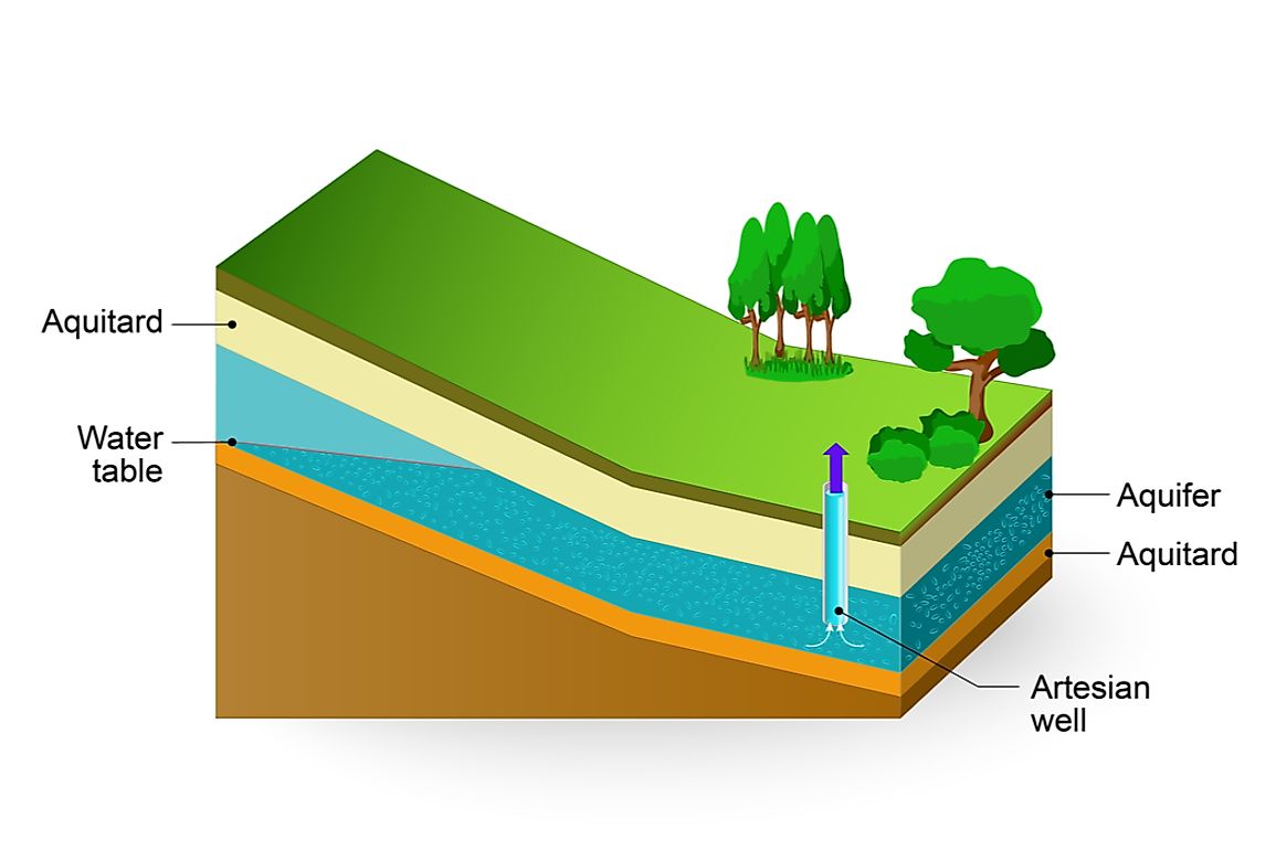
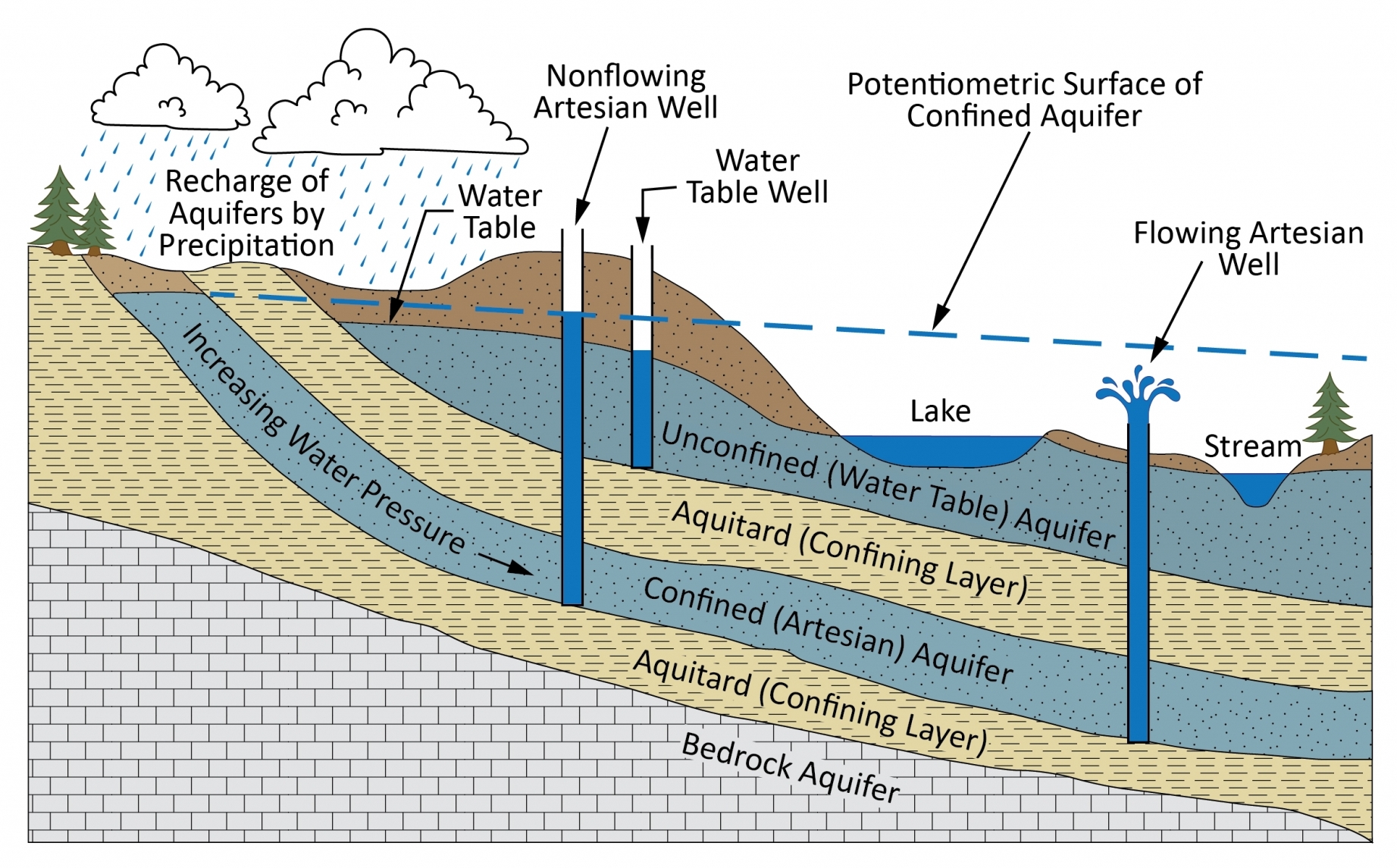
To the uninitiated, an aquitard might seem like a simple layer of clay or dense rock. However, in the tech-driven world of subsurface engineering, an aquitard is viewed as a complex “low-permeability unit” that regulates the flow of groundwater between different aquifers. It acts as a hydraulic gatekeeper.
Defining the Aquitard in a Digital Context
In digital hydrogeology, an aquitard is defined by its hydraulic conductivity—a measure of how easily a fluid can move through pore spaces or fractures. From a technological perspective, we define these layers through high-resolution data points. Unlike an “aquiclude,” which is entirely impermeable, an aquitard allows for some leakage. Modern tech allows us to quantify this leakage with extreme precision, turning a geological “wall” into a data-rich boundary layer that can be manipulated and monitored.
The Mechanics of Flow Retardation
The tech behind identifying these formations involves analyzing the porosity and interconnectivity of the subsurface matrix. Aquitards are typically composed of clay, silt, or shale. In the “Smart Water” era, engineers use these formations as natural filters. By understanding the mechanical properties of an aquitard through geotechnical software, developers can determine how long it will take for a contaminant to migrate from a surface spill into a deep-seated drinking water aquifer. This makes the aquitard a critical component in the “digital twin” models of urban environments.
Advanced Mapping and Sensing Technologies for Aquitard Identification
Identifying where an aquitard begins and ends used to involve a significant amount of guesswork and expensive physical drilling. Today, the tech sector has introduced non-invasive methods that provide a 3D visualization of the subsurface with unprecedented clarity.
Geophysical Imaging and Remote Sensing
One of the most significant breakthroughs in this field is the use of Airborne Electromagnetic (AEM) surveys. By flying a helicopter equipped with a massive hexagonal frame over a landscape, tech firms can map the electrical resistivity of the ground hundreds of meters deep. Because clay-rich aquitards conduct electricity differently than sand-rich aquifers, this data allows for the creation of high-definition “subsurface maps.”
Additionally, Ground Penetrating Radar (GPR) and seismic reflection—technologies borrowed and refined from the oil and gas industry—are now being deployed to identify thin aquitard layers that might be breached by industrial activity. These tools provide the “eyes” for environmental tech companies, allowing them to see through the Earth without moving a single shovelful of dirt.
AI and Machine Learning in Subsurface Characterization
The sheer volume of data produced by AEM surveys and seismic sensors is too vast for human analysts to process efficiently. Enter Machine Learning (ML). Modern environmental tech platforms now use ML algorithms to perform “automated lithology classification.”
By training neural networks on thousands of existing well logs, these systems can automatically identify aquitard boundaries in new datasets. This reduces the margin of human error and allows for real-time adjustments during construction or drilling projects. The integration of AI into hydrogeology has transformed the aquitard from a geological mystery into a predictable variable in a larger environmental equation.
Software Innovations in Groundwater Modeling and Aquitard Simulation

Once an aquitard is identified and mapped, the next technological frontier is simulation. How will this layer respond to heavy rainfall? How will it react if a nearby city pumps too much water from the aquifer below it? Solving these questions requires high-performance computing (HPC) and specialized software suites.
Predictive Analytics for Contaminant Transport
Software packages like MODFLOW (developed by the USGS but enhanced by private tech firms) are the industry standard for modeling groundwater flow. Recent iterations of this software have introduced “Variable-Density Flow” modules that specifically account for the unique physics of aquitards.
When a tech company manages a waste site, they use these simulations to create “Time-of-Travel” maps. These digital projections show exactly how an aquitard will retard the movement of pollutants over 10, 50, or 100 years. This predictive capability is a cornerstone of modern environmental compliance and risk management software, ensuring that industrial growth does not come at the cost of groundwater purity.
Digital Twins of Aquifer Systems
The concept of the “Digital Twin”—a virtual replica of a physical asset—is moving from manufacturing into the natural world. Hydrogeologists are now building digital twins of entire regional aquifer systems. In these models, the aquitard is a dynamic layer that can change its properties based on pressure and temperature.
For example, if an aquitard is compressed due to groundwater extraction (subsidence), the digital twin can predict how this will permanently alter the storage capacity of the underlying aquifer. This technology is vital for “Managed Aquifer Recharge” (MAR) projects, where water is intentionally pumped underground for storage. Without precise software modeling of the overlying aquitard, such projects could lead to ground instability or system failure.
The Impact of Aquitard Tech on Sustainable Infrastructure and Security
As we look toward the future, the technology surrounding aquitards is becoming a matter of national security and urban resilience. Protecting the integrity of these layers is essential for maintaining a reliable water supply in the face of climate change.
Protecting Urban Water Supplies via Smart Monitoring
The Internet of Things (IoT) has reached the subterranean world. “Smart Wells” are now equipped with pressure transducers and conductivity sensors that transmit data in real-time to cloud-based dashboards. These sensors are often placed directly above and below a critical aquitard.
If a sensor detects a sudden change in pressure or a spike in chemical concentration, the system can automatically trigger an alert or shut down nearby pumping stations. This automated response system is a hallmark of “Smarter Cities,” where the infrastructure is proactive rather than reactive. By treating the aquitard as a monitored barrier, tech-enabled municipalities can prevent large-scale water contamination events before they reach the consumer.
Cybersecurity in Water Management Systems
With the rise of digital water management comes a new tech challenge: cybersecurity. As our understanding of aquitards and aquifers becomes digitized and stored in the cloud, these “subsurface blueprints” become sensitive data. A bad actor with access to a city’s hydrogeological model could identify the weakest points in an aquitard where the water supply is most vulnerable to sabotage.
Consequently, the tech industry is now integrating blockchain and end-to-end encryption into groundwater databases. Protecting the data about the aquitard has become as important as protecting the physical layer itself. This intersection of geology, digital security, and infrastructure management highlights the evolving nature of environmental tech.
Conclusion
The aquitard may be an ancient geological feature, but its management has become a high-tech discipline. Through the lens of advanced sensing, AI-driven analytics, and IoT monitoring, this humble layer of clay has been reimagined as a sophisticated tool for environmental preservation.
As we continue to develop technologies that allow us to interact with the Earth in more precise and sustainable ways, the role of the aquitard will only grow in importance. By combining the physical sciences with the latest in software and hardware innovation, we are not just observing the subsurface; we are mastering it to ensure a more secure and water-stable future. For the modern tech professional, the “deep tech” of the future might just be found several hundred feet below their feet.
aViewFromTheCave is a participant in the Amazon Services LLC Associates Program, an affiliate advertising program designed to provide a means for sites to earn advertising fees by advertising and linking to Amazon.com. Amazon, the Amazon logo, AmazonSupply, and the AmazonSupply logo are trademarks of Amazon.com, Inc. or its affiliates. As an Amazon Associate we earn affiliate commissions from qualifying purchases.