
The moments leading up to a tornado are characterized by a violent, invisible struggle between atmospheric forces. For decades, the period “before the storm” was a mystery—a chaotic sequence of pressure drops and wind shifts that humans could only sense once it was too late. However, in the modern era, the question of what happens before a tornado is no longer answered by looking at the clouds, but by analyzing data streams.
Through the lens of advanced technology, the lead-up to a tornado is a complex digital narrative. It is a sequence of algorithmic triggers, radar pulses, and satellite observations that work in concert to provide a “lead time” that saves lives. To understand what happens before the funnel touches down, we must look at the sophisticated tech stack—from AI-driven forecasting to dual-polarization radar—that monitors the atmosphere’s every breath.
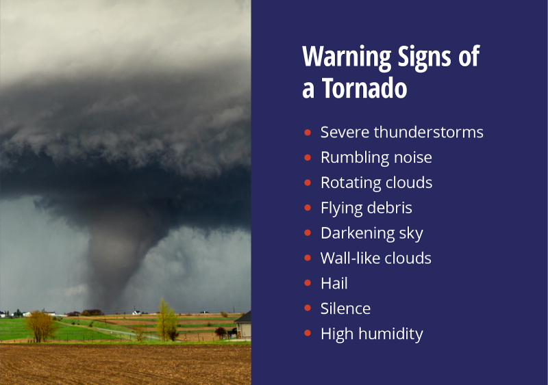
The Evolution of Early Warning Systems: From Human Observation to NEXRAD
Historically, the “technology” used to predict what happens before a tornado was limited to the human eye. Storm spotters would look for a “wall cloud” or a “hook echo” on primitive radar screens. Today, the infrastructure is vastly more sophisticated, centered around the Next-Generation Radar (NEXRAD) system and its recent technological upgrades.
From Analog Signals to Dual-Polarization Radar
The most significant leap in understanding the pre-tornado environment came with the implementation of Dual-Polarization (Dual-Pol) radar. Traditional radar sent out horizontal pulses, measuring the width of objects in the atmosphere. Dual-Pol technology sends both horizontal and vertical pulses. This allows meteorologists to distinguish between different types of precipitation—rain, hail, or snow—and, crucially, to identify the “debris ball” that forms even before a tornado is fully visible to the eye. This tech provides a three-dimensional view of the storm’s internal structure, allowing software to detect the “tornadic vortex signature” (TVS) with unprecedented accuracy.
Pulse-Doppler Technology and Velocity Mapping
What happens before a tornado is, essentially, a radical change in wind velocity. Pulse-Doppler radar technology measures the “Doppler shift” in the frequency of the returned signal. This allows the system to map wind speed and direction within a thunderstorm. By identifying “couplets”—areas where winds are moving rapidly toward and away from the radar in close proximity—the software can flag intense rotation. This technological ability to see “inside” the storm allows for warnings to be issued 15 to 30 minutes before the tornado actually forms, a feat that was impossible forty years ago.
Artificial Intelligence and Machine Learning in Tornado Genesis
The sheer volume of data produced by modern radar is too vast for human analysts to process in real-time. This is where Artificial Intelligence (AI) and Machine Learning (ML) have become the primary tools for understanding “tornadogenesis”—the scientific term for the birth of a tornado.
Neural Networks and Atmospheric Pattern Recognition
Leading meteorological institutions now employ Deep Learning models to analyze historical storm data. These neural networks are trained on thousands of past tornado events, learning the subtle atmospheric precursors that lead to a touchdown. Before a tornado occurs, these AI tools scan live data for specific patterns in temperature gradients and moisture levels. By comparing current conditions to a massive database of “successful” tornadogenesis events, the AI can assign a probability score to a storm cell, often identifying a potential tornado before a human meteorologist notices the rotation on a screen.
Reducing False Alarms with Deep Learning Models
One of the biggest challenges in tornado technology is the “false alarm ratio.” In the past, many warnings were issued for storms that never produced a tornado, leading to “warning fatigue” among the public. Modern ML algorithms are being refined to differentiate between a “mesocyclone” (a rotating thunderstorm) that will stay elevated and one that will produce a tornado. By analyzing variables like “low-level helicity” and “storm-relative inflow” at millisecond intervals, software can now filter out non-threatening rotations, ensuring that when an alert is sent, it is backed by high-confidence data.

The Role of Satellite and IoT Sensor Networks
While radar looks at the storm from the side, a suite of space-based and ground-based technologies monitors the environment from above and within. Understanding what happens before a tornado requires a holistic view of the Earth’s “boundary layer.”
Geostationary Operational Environmental Satellites (GOES)
The GOES-R series of satellites represents a massive leap in space technology. These satellites are equipped with the Geostationary Lightning Mapper (GLM). Research has shown that a “lightning jump”—a sudden, massive increase in lightning activity—often occurs minutes before a tornado forms. The GLM tracks these pulses from space, providing data to ground-based computers that correlate lightning frequency with storm intensification. This space-to-earth tech link is vital for monitoring storms in regions where radar coverage may be blocked by mountains or distance.
In-Situ Data Collection: Deploying IoT and Drone Probes
To truly understand the pressure drops that happen before a tornado, scientists are increasingly turning to Internet of Things (IoT) devices and unmanned aerial vehicles (UAVs). High-tech “probes” equipped with sensors for barometric pressure, humidity, and temperature are deployed in the path of developing storms. Furthermore, specialized drones are now being flown into the “inflow” of a storm—the air being sucked into the base of the clouds. This real-time, in-situ data is transmitted via cellular or satellite links to central servers, providing a granular look at the thermodynamic changes that act as the “fuse” for a tornado.
Edge Computing and the Speed of Alert Dissemination
Information is only as good as the speed at which it is delivered. The final stage of what happens before a tornado is the technological race to notify the public. This involves a complex web of edge computing and digital communication protocols.
WEA 3.0: Geo-targeted Mobile Alerts
Wireless Emergency Alerts (WEA) have evolved significantly. The latest iteration, WEA 3.0, uses advanced geo-fencing technology to ensure that alerts are delivered only to those within the specific “polygon” of danger defined by the National Weather Service. This minimizes “over-warning” and uses the GPS capabilities of modern smartphones to provide a localized countdown. The tech behind this involves high-speed coordination between weather software, cellular carriers, and the FEMA Integrated Public Alert and Warning System (IPAWS).
The Future: Quantum Computing in Meteorological Forecasting
As we look toward the future, the next frontier in understanding the pre-tornado environment is Quantum Computing. Traditional supercomputers struggle with the “chaos theory” inherent in weather—small changes in initial conditions can lead to vastly different outcomes. Quantum computers, with their ability to process multiple variables simultaneously, could theoretically simulate the entire atmosphere of a local county in real-time. This would allow meteorologists to predict exactly where a tornado will form hours, rather than minutes, in advance.

Conclusion: A Tech-Shield Against the Storm
What happens before a tornado is no longer a silent buildup of atmospheric tension. In the digital age, it is a loud, data-rich event. It is the sound of radar pulses bouncing off hydrometeors, the sight of lightning jumps captured by satellites 22,000 miles away, and the logic of AI algorithms processing billions of data points.
While we cannot yet stop a tornado, our technological “eyes” are becoming sharper. By integrating AI, Dual-Pol radar, satellite imagery, and high-speed alert systems, we have moved from a reactive stance to a proactive one. The technology of today doesn’t just watch the storm; it anticipates it, translating the invisible precursors of nature into actionable intelligence. As these technologies continue to converge, the “lead time” will grow, and the mystery of what happens before a tornado will be replaced by the precision of digital foresight.
aViewFromTheCave is a participant in the Amazon Services LLC Associates Program, an affiliate advertising program designed to provide a means for sites to earn advertising fees by advertising and linking to Amazon.com. Amazon, the Amazon logo, AmazonSupply, and the AmazonSupply logo are trademarks of Amazon.com, Inc. or its affiliates. As an Amazon Associate we earn affiliate commissions from qualifying purchases.