
In the global landscape of logistics and data management, few systems are as iconic yet misunderstood as the American postal code system. While much of the world uses the term “postcode,” the United States operates under the ZIP Code system. Far from being a mere string of numbers used to sort envelopes, the ZIP code has evolved into a sophisticated technological framework that powers global e-commerce, geospatial data analytics, and complex software algorithms.
To understand what a postcode is in the USA, one must look beyond the mailbox. It is the fundamental unit of the United States’ digital and physical routing infrastructure.

The Evolution of the ZIP Code: From Paper Sorting to Digital Algorithms
The term “ZIP” is actually an acronym for the Zone Improvement Plan. Introduced by the United States Postal Service (USPS) in 1963, it was designed to manage the exploding volume of mail in a post-WWII economy. However, the transition from a manual filing system to a high-tech data protocol is where the real story lies.
The Anatomy of the Data String
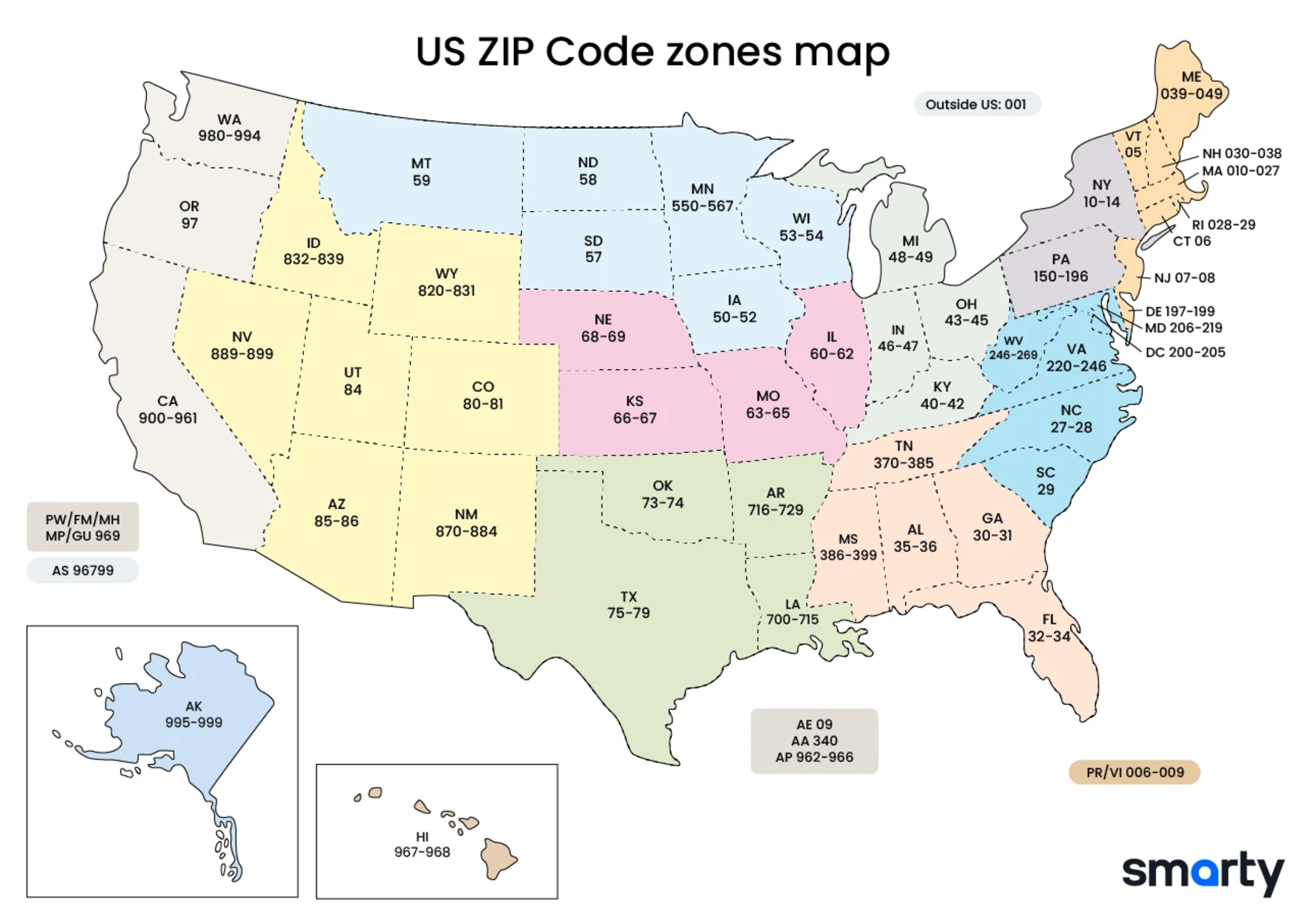
A standard U.S. ZIP code consists of five numerical digits. In the world of database management and software engineering, these aren’t just numbers; they are hierarchical data strings:
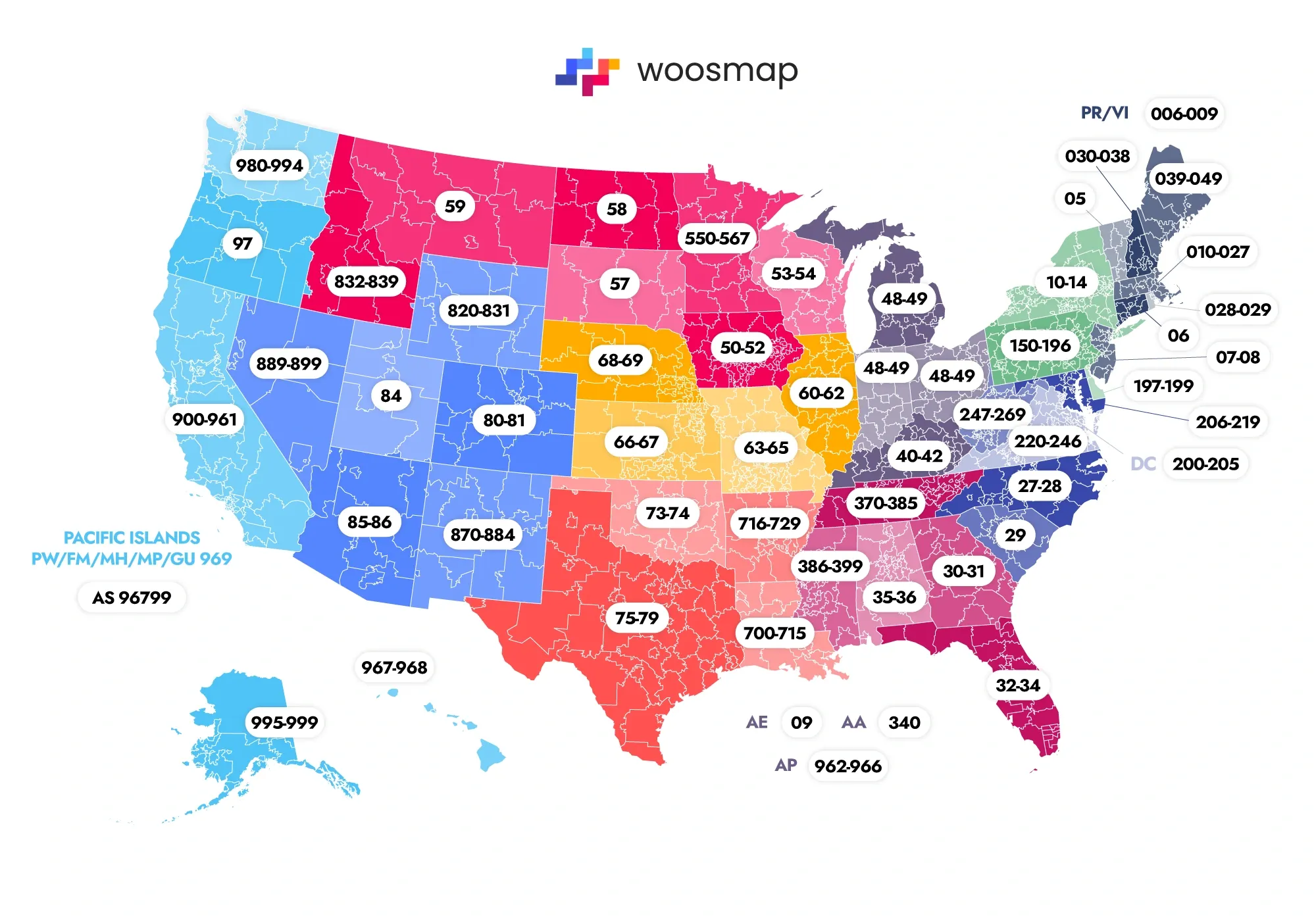
- The First Digit: Represents a broad geographical group of states (e.g., ‘0’ for the Northeast, ‘9’ for the West Coast).
- The Second and Third Digits: Identify a central post office facility or “sectional center” that processes mail for a specific region.
- The Fourth and Fifth Digits: Define a specific local post office or delivery area.
In 1983, the system expanded into the ZIP+4. This added a hyphen and four extra digits to identify a specific city block, a large office building, or even a high-volume individual mail receiver. From a technical perspective, this turned the ZIP code into a high-resolution coordinate system long before GPS was a household utility.
From OCR to Machine Learning
In the early days, postal workers sorted mail by hand. Today, the “postcode” is processed by advanced Optical Character Recognition (OCR) technology. Modern sorting machines can read handwritten ZIP codes, convert them into a digital “barcode,” and sort thousands of pieces of mail per minute. This was one of the earliest widespread applications of computer vision and automated pattern recognition, setting the stage for the AI-driven logistics we see today.
Geospatial Technology and the Logic of the ZIP Code
A common misconception in tech circles is that a ZIP code represents a polygon on a map. In reality, a ZIP code is a collection of delivery routes. This distinction is vital for developers working with Geographic Information Systems (GIS) and mapping APIs.
The Role of TIGER Files and Census Data
The U.S. Census Bureau utilizes the ZIP Code Tabulation Area (ZCTA) to bridge the gap between postal routes and statistical geography. Tech professionals use TIGER (Topologically Integrated Geocoding and Referencing) files to map these codes. These files are the backbone of most digital mapping software, allowing developers to overlay demographic data, consumer behavior, and infrastructure requirements onto specific ZIP code coordinates.
Mapping Software and API Integration
For software developers, the ZIP code is a primary key in many databases. When you enter a ZIP code on a website and the “City” and “State” fields auto-populate, the application is performing a “reverse geocoding” look-up via an API.
- Google Maps Platform: Uses ZIP data to provide boundaries for local SEO and service-area businesses.
- Mapbox and Esri: Use ZIP codes as layers for data visualization, helping tech companies determine where to build new data centers or where to deploy fiber-optic networks.
The logic of the USA postcode is integrated into the core of the modern web, serving as the bridge between an IP address in the digital world and a physical doorstep in the real world.
Logistics, E-commerce, and the Power of Algorithmic Routing
The most profound impact of the U.S. postcode system is felt in the e-commerce sector. Without the 5+4 digit precision of the ZIP code, the “Prime” delivery speed we have come to expect would be technologically impossible.
Last-Mile Delivery Tech
The “Last Mile” is the most expensive and complex part of the supply chain. Delivery giants like Amazon, FedEx, and UPS use the ZIP code as the foundational data point for their routing algorithms. By grouping deliveries within specific ZIP+4 segments, AI-driven dispatch software can calculate the most fuel-efficient and time-sensitive route for a driver.
This involves solving the “Traveling Salesperson Problem” at scale. Software like Amazon’s Rabbit system or UPS’s ORION (On-Road Integrated Optimization and Navigation) processes ZIP code data alongside real-time traffic updates to shave seconds off every delivery—a feat that saves companies billions of dollars annually.
Dynamic Pricing and Automated Sorting
In many SaaS platforms and e-commerce engines, the ZIP code triggers dynamic pricing. Shipping APIs (like ShipStation or EasyPost) query the ZIP code to calculate real-time shipping rates, taxes, and estimated delivery times. Automated sorting facilities use the ZIP code to direct packages onto specific conveyor belts that lead to outbound trucks, creating a seamless flow of data-to-physical-movement.
Data Security and Privacy in Location-Based Services
As the ZIP code became a ubiquitous digital identifier, it also became a focal point for digital security and data privacy discussions. In the tech industry, the ZIP code is often categorized as a piece of “quasi-identifier” data.
ZIP Codes as Personal Identifiable Information (PII)
While a ZIP code alone doesn’t name a person, it is a powerful tool for “re-identification.” Data scientists have famously demonstrated that by combining a ZIP code with a birthdate and gender, they can uniquely identify a significant percentage of the U.S. population.
This has led to strict regulations in how tech companies handle ZIP code data:
- The Netflix Prize Case: Researchers were able to de-anonymize a “private” dataset by cross-referencing movie ratings with ZIP code-based public data.
- CCPA and GDPR: In certain contexts, California’s privacy laws treat the collection of ZIP codes as a potential privacy risk, especially when used for tracking consumer movements without consent.
Geofencing and Digital Advertising
In the world of AdTech (Advertising Technology), ZIP codes are used for geofencing. Marketers use software to serve ads only to users whose mobile devices are reporting a location within a specific ZIP code. This precision allows for hyper-local targeting, but it also raises technical challenges regarding GPS spoofing and the ethical use of location data.
The Future of Postcodes: Smart Cities and Hyper-Local Data
As we move toward a future of autonomous vehicles and drone deliveries, the traditional 5-digit ZIP code is evolving. The tech industry is currently looking at how to make “postcodes” even more granular.
Drone Delivery and GPS Precision
A ZIP+4 code covers a city block, but a delivery drone needs to find a specific balcony or a 4×4-foot landing pad. We are seeing the emergence of “digital addresses” or “micro-codes” that act as an extension of the traditional ZIP code system. These systems use latitude and longitude coordinates translated into short, readable alphanumeric strings to provide centimeter-level accuracy for autonomous systems.
Decentralized Location Systems
Some tech innovators are exploring blockchain-based addressing systems. By decentralizing location data, these systems aim to provide the same routing efficiency as the USPS ZIP code while giving users more control over who can “ping” their physical location. This “Postcode 2.0” would function as an encrypted token that only authorized delivery bots can decrypt.
Conclusion
So, what is a postcode in the USA? It is far more than a 5-digit number on a letter. In the modern era, the ZIP code is a sophisticated piece of logistics software, a geospatial data point, and a digital identifier. It is the invisible thread that connects a line of code in an e-commerce database to a physical package arriving at a consumer’s home.
As technology continues to advance—through AI, autonomous logistics, and enhanced data privacy protocols—the ZIP code will remain the bedrock of the United States’ physical and digital infrastructure. For tech professionals and businesses alike, understanding the logic, the limitations, and the potential of this system is essential for navigating the complex world of modern American commerce.
aViewFromTheCave is a participant in the Amazon Services LLC Associates Program, an affiliate advertising program designed to provide a means for sites to earn advertising fees by advertising and linking to Amazon.com. Amazon, the Amazon logo, AmazonSupply, and the AmazonSupply logo are trademarks of Amazon.com, Inc. or its affiliates. As an Amazon Associate we earn affiliate commissions from qualifying purchases.