
In the global landscape of telecommunications and logistics, the term “postal code” serves as a universal identifier for geographic regions. However, in the United States, this system is uniquely codified as the ZIP (Zone Improvement Plan) code. While the average consumer views these five to nine digits as a simple requirement for shipping a package, the reality is far more complex. To the technologist, the US ZIP code system represents a sophisticated data framework— a digital backbone that powers trillion-dollar e-commerce industries, enables precise geospatial mapping, and facilitates the complex algorithms of modern last-mile delivery.

Understanding the “what” and “how” of the US postal code requires a deep dive into the intersection of legacy infrastructure and cutting-edge software engineering. As we move toward an increasingly automated world, the ZIP code remains the primary key in the database of American logistics.
The Anatomy of a ZIP Code: From Manual Sorting to Algorithmic Precision
The ZIP code system was introduced by the United States Postal Service (USPS) in 1963, but its technological evolution has been relentless. Originally designed to help manual sorters categorize mail faster, the system has transitioned into a machine-readable language that communicates directly with high-speed optical scanners and automated distribution centers.
The Transition from 5-Digit to ZIP+4
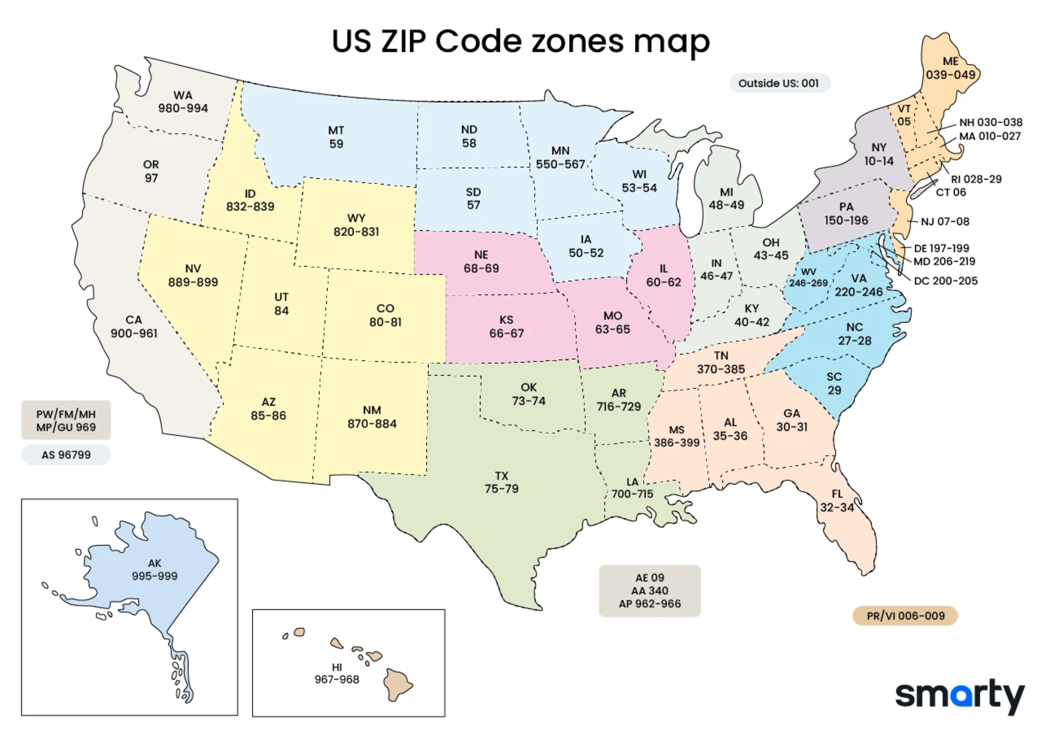
A standard US ZIP code consists of five numerical digits. The first digit represents a broad group of U.S. states, the second and third digits represent a central post office facility in that region, and the final two digits represent a specific post office or delivery area.
However, the tech-driven expansion of the 1980s introduced the “ZIP+4” code. This four-digit add-on identifies a specific geographic segment, such as a city block, a group of apartments, or an individual high-volume receiver. From a data perspective, the ZIP+4 code drastically reduces the “search area” for delivery algorithms, allowing for high-resolution geofencing and more efficient sorting logic within automated mail processing facilities.
How Optical Character Recognition (OCR) Revolutionized Mail Processing
The modern postal system is a marvel of computer vision. Every piece of mail entering the USPS ecosystem is scanned by Optical Character Recognition (OCR) software. This technology analyzes the handwritten or printed ZIP code, converts the image into digital data, and applies a POSTNET barcode. This barcode is then read by high-speed sorting machines that can process tens of thousands of items per hour. This transition from human interpretation to machine learning-driven sorting was one of the earliest large-scale applications of automated data entry in the American public sector.
ZIP Codes in the Era of E-Commerce and Real-Time Logistics
For modern tech giants like Amazon, FedEx, and UPS, the ZIP code is more than a location—it is a data variable used to calculate shipping latency, cost, and route density. In the world of e-commerce, the “Postal Code of the US” serves as the primary input for the algorithms that govern global supply chains.
Last-Mile Delivery Optimization and Route Planning Software
The “last mile” is the most expensive and complex part of the delivery process. Logistics software utilizes ZIP code data to cluster deliveries into optimal routes. By analyzing the density of packages within a specific ZIP code, machine learning models can predict the most efficient path for a driver, accounting for traffic patterns, fuel consumption, and time windows.
Software suites integrated with the USPS database allow companies to perform “delivery point validation.” This ensures that a ZIP code entered by a customer on an e-commerce site actually exists and corresponds to a deliverable address, preventing costly “Return to Sender” errors and reducing database “noise.”
The Role of Geospatial Data in Supply Chain Management
Logistics technology relies on the conversion of ZIP codes into latitude and longitude coordinates—a process known as geocoding. This conversion allows supply chain managers to visualize their distribution networks on a digital map. By analyzing ZIP code clusters, companies can strategically locate their “Fulfillment Centers” (FCs) to ensure that the highest volume of customers are within a one-day shipping radius. This spatial analysis is the secret sauce behind the rapid delivery times that modern consumers have come to expect.
Geolocation APIs and Digital Identity
In the digital realm, ZIP codes serve as a bridge between the physical and virtual worlds. They are frequently used as a form of “light” authentication and a primary filter for localized digital content.
Integrating USPS and Google Maps APIs for Address Validation
Software developers rarely build address databases from scratch. Instead, they leverage Application Programming Interfaces (APIs). The USPS provides an API that allows developers to verify ZIP codes in real-time. Similarly, the Google Maps Platform’s Geocoding API allows applications to translate a US ZIP code into a rich set of metadata, including neighborhood names, time zones, and administrative boundaries.
When a user enters their ZIP code into a weather app or a retail “store locator,” the software uses these APIs to fetch relevant data. This seamless integration of postal data into web architecture is fundamental to the personalized user experience (UX) that defines modern software.
Data Integrity: Why Accurate Postal Data is Crucial for Cybersecurity
ZIP codes also play a surprising role in digital security. In “Address Verification Service” (AVS) protocols used by credit card processors, the ZIP code provided during an online checkout is matched against the billing address on file with the bank. If the ZIP codes do not match, the transaction is flagged as potential fraud. This simple five-digit check remains one of the most effective automated tools for preventing unauthorized digital transactions.
Furthermore, in the world of big data and analytics, “data normalization” often starts with the ZIP code. Ensuring that geographic data is formatted correctly is essential for preventing data silos and ensuring that cybersecurity protocols can accurately track the origin of localized network traffic.
The Future of Mapping: Beyond the ZIP Code
As we look toward the future of technology, the traditional ZIP code is being augmented—and in some cases, challenged—by even more precise digital mapping systems. However, the legacy of the US postal code continues to influence how we build smart infrastructure.
Smart Cities and the Integration of IoT with Postal Infrastructure
The concept of the “Smart City” involves the use of Internet of Things (IoT) sensors to manage urban assets. In this context, the ZIP code serves as a foundational layer for organizing data. For example, smart grids use ZIP code boundaries to monitor energy consumption patterns and manage load balancing. Future postal tech may involve “smart mailboxes” that notify the USPS of their volume in real-time, allowing for dynamic route adjustments based on the digital signals sent from specific postal zones.
Autonomous Delivery Drones and Precision Geocoding
While a ZIP code is sufficient for a human driver, an autonomous delivery drone requires even higher precision. We are seeing a shift toward “Micro-codes” or “three-word addresses” that can pinpoint a location within a few square meters. Nevertheless, these high-precision systems are still indexed against the existing US ZIP code framework.
The transition to drone delivery will require a sophisticated interplay between traditional postal data and real-time 3D mapping. The ZIP code will likely remain the high-level organizational unit, while GPS coordinates handle the granular navigation. This hybrid approach ensures that new technologies remain compatible with the existing multi-billion dollar infrastructure of the US postal system.

Conclusion: The Enduring Code
The question “what is the postal code of the US” may seem simple on the surface, but for those in the technology and logistics sectors, it is a query that unlocks a vast ecosystem of data and automation. From the OCR scanners of the 20th century to the AI-driven logistics of today, the ZIP code has proven to be an incredibly resilient and scalable piece of technology.
As we move forward into an era of autonomous vehicles, blockchain-based supply chains, and smart urban environments, the ZIP code will continue to evolve. It is no longer just a way to sort mail; it is a vital data point that facilitates global commerce, secures our digital transactions, and maps our world. In the digital age, the US postal code is not just an address—it is the code that connects the physical world to the digital frontier.
aViewFromTheCave is a participant in the Amazon Services LLC Associates Program, an affiliate advertising program designed to provide a means for sites to earn advertising fees by advertising and linking to Amazon.com. Amazon, the Amazon logo, AmazonSupply, and the AmazonSupply logo are trademarks of Amazon.com, Inc. or its affiliates. As an Amazon Associate we earn affiliate commissions from qualifying purchases.