
In the landscape of global logistics and digital data management, the American postal code—officially known as the ZIP Code—serves as more than just a routing number for paper mail. It is a fundamental component of the United States’ technological infrastructure. For software developers, data scientists, and digital security experts, the ZIP (Zone Improvement Plan) code represents a sophisticated system of geographic categorization that powers everything from e-commerce algorithms to localized cybersecurity protocols.
Understanding what the postal code of America is requires looking beyond the five digits printed on an envelope. It involves exploring a complex network of database management, automated sorting technologies, and geospatial data points that define the modern American digital economy.

The Evolution of ZIP Codes: From Manual Sorting to Algorithmic Efficiency
The ZIP code system was introduced by the United States Postal Service (USPS) in 1963. While it began as a solution to the overwhelming volume of mail following World War II, its evolution has been strictly tied to the advancement of computing technology. In its infancy, the system was designed to help human sorters quickly identify the destination of a package. Today, those same numbers are the primary keys in massive relational databases.
The Origin of the Zone Improvement Plan
The term “ZIP” is an acronym for Zone Improvement Plan, a title chosen to suggest that mail would travel more quickly—or “zippily”—if coded correctly. The initial five-digit format was revolutionary for its time, creating a hierarchical data structure. The first digit represents a broad group of U.S. states, the second and third digits represent a central post office facility in that region, and the final two digits represent a specific post office or delivery area.
From a tech perspective, this was one of the first successful implementations of a nationwide standardized data entry system. It forced a level of uniformity across diverse geographic regions, allowing for the eventual transition from manual labor to machine-readability.
Digitizing the Mail Stream and Optical Character Recognition
In the late 20th century, the ZIP code system underwent a massive technological upgrade with the introduction of Optical Character Recognition (OCR). This technology allows high-speed sorters to “read” handwritten or printed addresses, cross-reference them with a database of valid ZIP codes, and apply a barcode to the mailpiece.
This transition marked the point where the postal code moved from a physical necessity to a digital asset. Modern OCR systems used by the USPS can process over 30,000 pieces of mail per hour, utilizing advanced image processing algorithms that identify the ZIP code as the primary anchor for routing logic.
The Technology Behind ZIP+4: Precision Geolocation and Database Management
As the density of the American population increased and the complexity of digital delivery grew, the standard five-digit code became insufficient for the precision required by modern logistics software. In 1983, the USPS introduced the “ZIP+4” code, an expansion that added a hyphen and four additional digits to the existing code.
How the Extra Four Digits Revolutionized Data Granularity
The ZIP+4 code provides a level of granularity that is essential for high-tech mapping and delivery systems. While the first five digits identify the general delivery area, the extra four digits pinpoint a specific city block, a large office building, or even a specific floor within a skyscraper.
For developers building logistics software or delivery apps, the ZIP+4 is a critical data point. It reduces the “margin of error” in geolocation. Instead of directing a driver to a general neighborhood, the +4 suffix allows GPS software to calculate the exact “last-mile” coordinates, significantly reducing fuel consumption and increasing the efficiency of automated routing engines.
Navigating the National Deliverability Index
The USPS maintains a massive, constantly updated database known as the National Deliverability Index (NDI). This is the “source of truth” for every valid address in the United States. Tech companies license this data to ensure that their software doesn’t attempt to process shipments to non-existent locations.
This database management is a feat of data engineering. It handles millions of updates annually as new developments are built and old ones are demolished. In the tech world, this is a prime example of a dynamic, high-availability database that serves as the backbone for an entire nation’s commercial infrastructure.
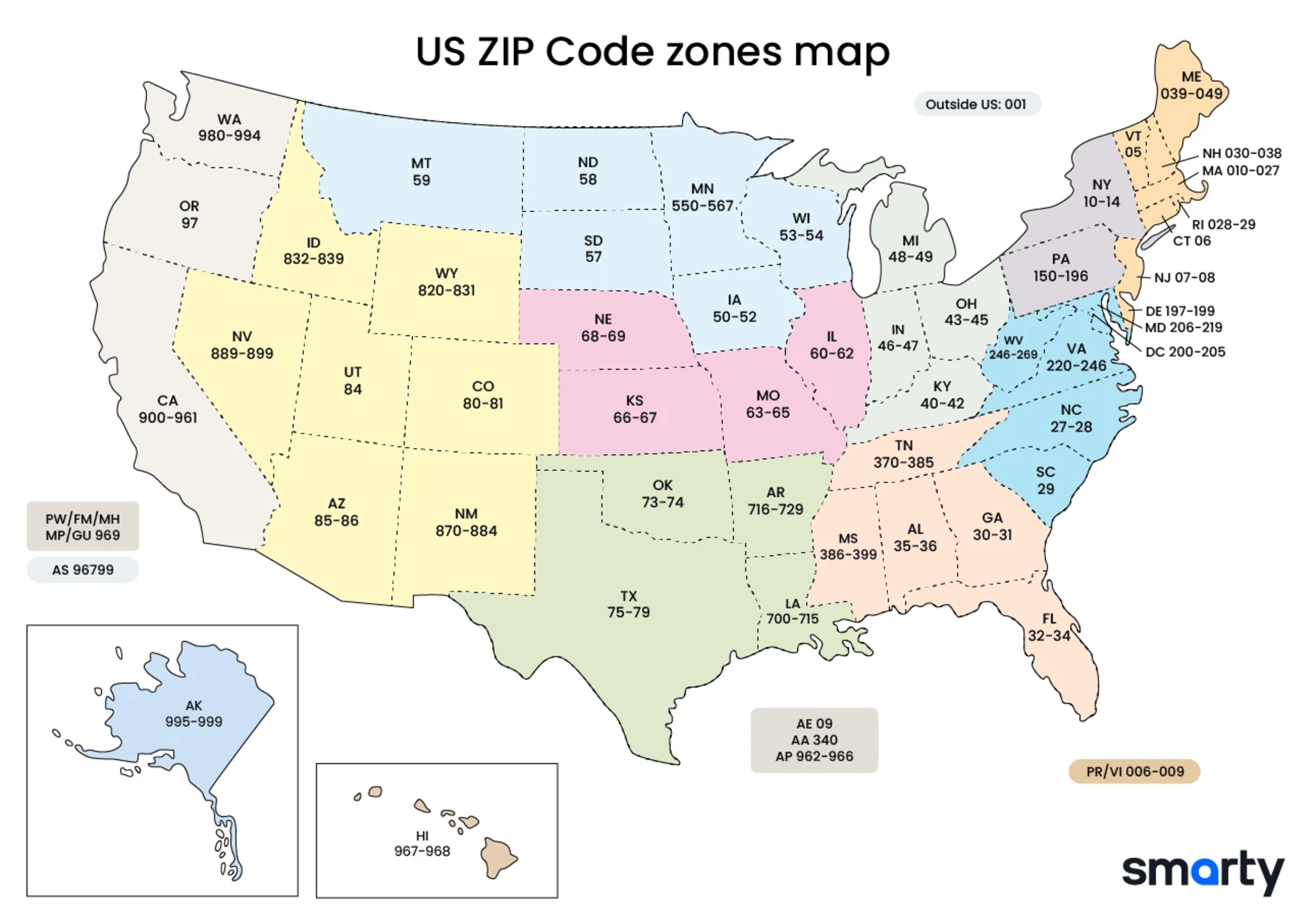
Integrating Postal Codes into Modern Tech Stacks
For the modern software engineer, a postal code is rarely just a string of numbers in a database. It is a tool for validation, a metric for analytics, and a shield for digital security. Integrating US postal code data into a tech stack requires an understanding of various APIs and security protocols.
API Integration for Address Validation
Most modern e-commerce platforms do not simply allow a user to type in an arbitrary ZIP code. Instead, they use Address Validation APIs (such as those provided by Smarty, Google Maps, or the USPS itself). These APIs perform a real-time “handshake” with the database to verify that the ZIP code matches the city and state provided.
This integration is vital for “Clean Data” practices. By validating at the point of entry, companies prevent “garbage in, garbage out” scenarios where incorrect shipping data leads to costly logistics errors. These APIs often return more than just a confirmation; they provide latitude and longitude coordinates, time zone data, and even demographic indicators used in backend processing.
Role in Cybersecurity and Fraud Detection
In the realm of digital security, the ZIP code is a primary factor in the Address Verification System (AVS). When you make an online purchase with a credit card, the payment gateway checks the ZIP code provided against the billing address on file with the issuing bank.
This is a critical layer of fraud prevention. If a hacker has your credit card number but not your billing ZIP code, the transaction is likely to be flagged or declined. From a tech standpoint, this involves rapid, encrypted communication between the merchant’s server, the payment processor, and the banking infrastructure, all centered around those five digits.
The Future of Spatial Data: AI and Machine Learning in Last-Mile Delivery
As we move further into the era of artificial intelligence, the role of the American postal code is shifting once again. No longer just a static identifier, it is now a foundational element of predictive analytics and machine learning models aimed at optimizing the “last mile” of delivery.
Predictive Analytics for Route Optimization
Machine learning algorithms now ingest decades of ZIP-code-based delivery data to predict traffic patterns, weather impacts, and delivery density. By analyzing historical data tied to specific postal codes, AI can predict that a certain ZIP code in Manhattan will experience delays on Friday afternoons, allowing logistics software to reroute drivers in real-time.
This level of predictive tech is what allows companies like Amazon and FedEx to offer same-day or next-day delivery. The ZIP code serves as the primary “bucket” for this data, allowing AI to categorize and process information at scale.
The Impact of Geographic Information Systems (GIS)
Geographic Information Systems (GIS) are the software tools used to visualize and analyze spatial data. In the United States, the ZIP code is one of the most common layers in GIS mapping. This technology is used by tech companies to decide where to place new data centers, by telecommunications firms to map out 5G tower deployments, and by urban planners to visualize digital divide gaps.
The future of the American postal code lies in this “Smart City” integration. We are moving toward a reality where your ZIP code might interact with autonomous delivery drones or self-driving mail trucks. These machines will rely on the digital “fence” created by postal code boundaries to navigate the physical world safely and efficiently.
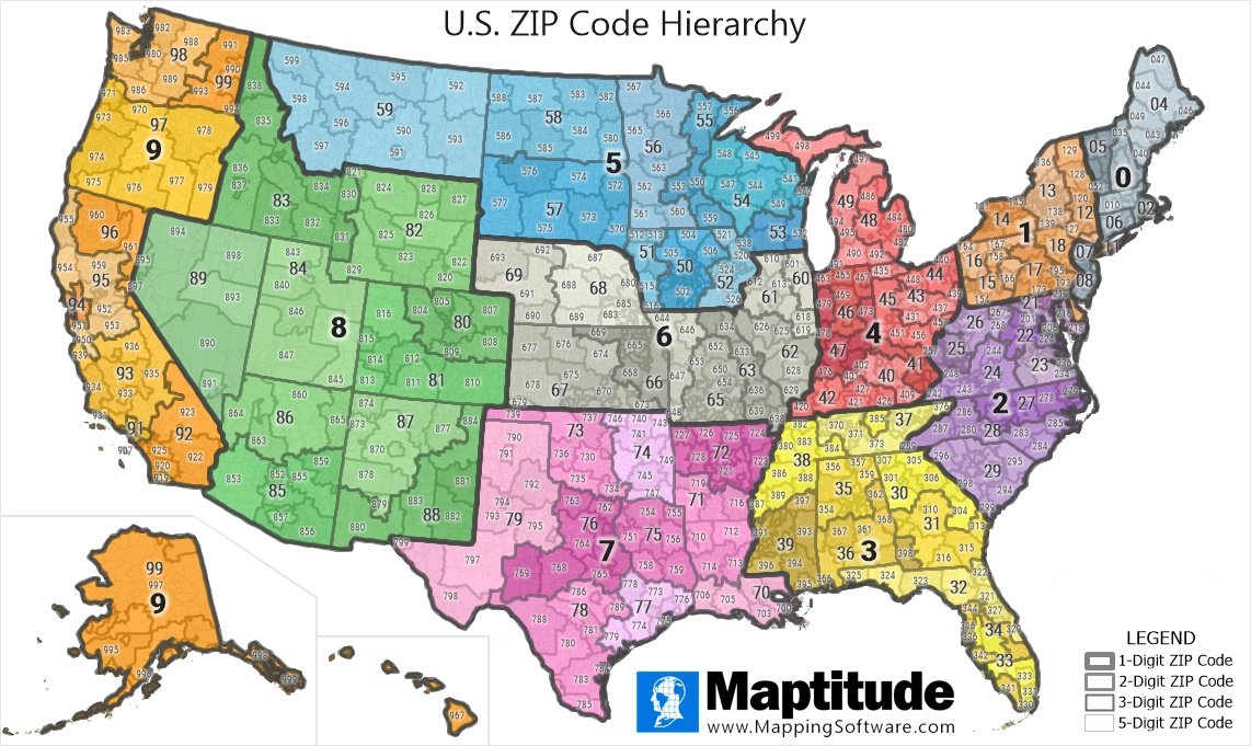
Conclusion: The Number That Maps a Nation
While the question “what is the postal code of America” might seem simple, the answer is a testament to the power of standardized data. There is no single code for the entire country; instead, there is a sophisticated system of over 42,000 individual ZIP codes that form a digital grid over the United States.
For the tech community, the ZIP code is a masterclass in how a legacy system can be adapted for the digital age. It has evolved from a tool for manual sorters into a high-octane data point that fuels APIs, secures financial transactions, and trains machine learning models. As technology continues to advance, the humble ZIP code will remain a cornerstone of American digital and physical infrastructure, proving that even the simplest strings of data can move the world.
aViewFromTheCave is a participant in the Amazon Services LLC Associates Program, an affiliate advertising program designed to provide a means for sites to earn advertising fees by advertising and linking to Amazon.com. Amazon, the Amazon logo, AmazonSupply, and the AmazonSupply logo are trademarks of Amazon.com, Inc. or its affiliates. As an Amazon Associate we earn affiliate commissions from qualifying purchases.