The question “What native land am I on?” has transformed from a localized inquiry into one of the most significant geospatial data movements of the digital age. In an era defined by precision GPS, satellite imagery, and complex data visualization, the effort to map Indigenous territories is not merely a social project but a sophisticated technological challenge. By leveraging Geographic Information Systems (GIS), open-source APIs, and mobile application development, tech innovators are bridging the gap between ancient history and modern digital awareness.
As we look deeper into the “Tech” niche of this topic, we find a landscape where software engineering meets cultural preservation, and where the ethics of data sovereignty are being rewritten for the 21st century.
The Intersection of Geospatial Technology and Indigenous History
At its core, the ability to answer “What native land am I on?” relies on the robustness of Geographic Information Systems (GIS). GIS technology allows for the layering of data—topography, climate, political borders, and historical boundaries—into a cohesive digital interface. However, mapping Indigenous lands presents unique technical hurdles that traditional mapping software, like Google Maps or OpenStreetMap, was not originally designed to handle.
From Paper to Pixels: The Digital Transition
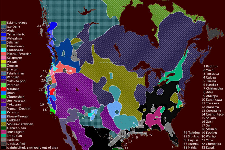
Historically, Indigenous territories were often recorded through oral tradition or illustrated on physical maps that lacked the precise coordinates required for modern software. The digital transition involves digitizing these records into “shapefiles” or GeoJSON formats. This process requires high-level data cleaning and validation. Tech developers must reconcile overlapping boundaries, as many Indigenous nations shared territories or moved seasonally—concepts that traditional “hard-border” mapping software often struggles to represent.
The Role of Crowdsourcing and Open-Source Data
The most successful platforms answering the query of native land use a crowdsourced model supported by open-source software. By allowing communities to contribute their own data points, developers can create a more accurate, living map. Open-source frameworks like Leaflet or Mapbox allow developers to build interactive, responsive maps that can handle millions of pings from users looking to identify their current location in relation to ancestral lands.
Leading Platforms and the Architecture of Modern Land Identification
When a user types “What native land am I on?” into a search engine, they are likely to encounter platforms that represent the pinnacle of modern web development and database management. These platforms are more than just websites; they are complex ecosystems of interconnected data.
Native Land Digital: A Case Study in Open-Source API
Native Land Digital (Native-Land.ca) is the gold standard in this tech niche. From a developer’s perspective, the platform’s power lies in its API (Application Programming Interface). By providing an open API, Native Land Digital allows other software developers to integrate Indigenous land data into their own applications. For example, a real estate app or an educational tool can “call” the Native Land API to pull localized data based on a user’s latitude and longitude. This modularity is a hallmark of modern software architecture, promoting interoperability across the web.
How Mobile GPS Integration Drives Awareness
The shift from desktop-first to mobile-first usage has necessitated a focus on mobile optimization. Modern land-identification apps utilize the “Geolocation API” built into mobile browsers and operating systems (iOS and Android). When a user grants permission, the app retrieves the precise GPS coordinates of the device and cross-references them against a database of polygons representing tribal territories. The technical challenge here is latency; developers must optimize their spatial databases (using tools like PostGIS) to ensure that these complex polygon lookups happen in milliseconds, providing a seamless user experience.

Ethical Tech: Challenges in Data Sovereignty and Representation
The digitization of Indigenous land data brings about a critical discussion regarding “Digital Sovereignty.” This refers to the right of a community to own, control, and access their own data. In the tech world, this involves complex questions about server locations, data encryption, and intellectual property.
The Responsibility of Tech Developers in Cultural Context
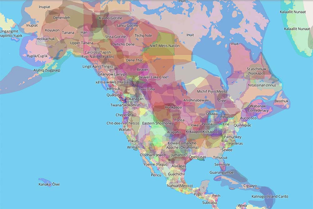
Software engineers and data scientists are often trained to treat data as objective numbers. However, mapping Indigenous land requires a more nuanced approach. Tech developers must implement features that acknowledge the fluidity of these boundaries. For instance, instead of a “hard line” on a map, sophisticated UI/UX design might use gradients or overlapping transparencies to signify shared or disputed territories. This is a technical solution to a cultural problem, requiring a high degree of collaboration between coders and historians.
Protecting Sensitive Data and Oral Traditions
One of the most significant risks in the tech-driven mapping of Indigenous lands is the potential for data misuse. For example, mapping sacred sites could lead to unauthorized visits or looting. Therefore, the tech stacks behind these platforms must include robust security protocols and “obfuscation layers.” Developers use “fuzzing” techniques to provide general locations for sensitive areas without revealing exact coordinates, protecting the integrity of the land while still providing educational value. This balance of transparency and security is a major focus for ethical tech startups in this space.
The Future of Geo-Tech: VR, AR, and Immersive Education
As we look toward the future, the question “What native land am I on?” will be answered through even more immersive technologies. The evolution of the mobile web into the spatial web (Web 3.0 and the Metaverse) offers new ways to visualize history and geography.
Augmenting Reality to Visualize Ancestral Boundaries
Augmented Reality (AR) is set to revolutionize how we interact with our environment. Imagine holding up a smartphone or wearing AR glasses (like Apple Vision Pro or Meta Quest) and seeing the physical world overlaid with digital markers of the Indigenous history of that specific spot. Technically, this requires “VPS” (Visual Positioning Systems) that go beyond standard GPS to understand the user’s exact orientation and perspective. This tech would allow users to see 3D reconstructions of historical structures or traditional land uses in real-time, effectively turning the entire world into a digital museum.
Machine Learning and the Restoration of Language through Place
Machine Learning (ML) is also playing a role in this tech niche. AI algorithms are being trained to process historical texts and linguistic data to help recreate lost place names. By analyzing patterns in Indigenous languages and geographical features, ML can suggest traditional names for mountains, rivers, and valleys that may have been omitted from colonial maps. For developers, this involves Natural Language Processing (NLP) integrated with geospatial datasets, creating a powerful tool for cultural and linguistic revitalization.
Conclusion: Tech as a Bridge to the Past
The technology behind answering “What native land am I on?” is a testament to how far we have come in our ability to manage and visualize complex data. From the backend power of PostGIS and open-source APIs to the frontend beauty of AR and interactive maps, the tech industry is providing the tools necessary for a deeper understanding of our global landscape.
As these tools continue to evolve, the focus will remain on accuracy, ethical data management, and user accessibility. By treating Indigenous land data with the same technical rigor as financial or scientific data, the tech community is ensuring that the digital maps of the future are not only precise but also inclusive and respectful of the diverse histories that define our world. In the end, the technology serves as a bridge, connecting the digital citizens of today with the ancestral lands that have supported human life for millennia.
aViewFromTheCave is a participant in the Amazon Services LLC Associates Program, an affiliate advertising program designed to provide a means for sites to earn advertising fees by advertising and linking to Amazon.com. Amazon, the Amazon logo, AmazonSupply, and the AmazonSupply logo are trademarks of Amazon.com, Inc. or its affiliates. As an Amazon Associate we earn affiliate commissions from qualifying purchases.