
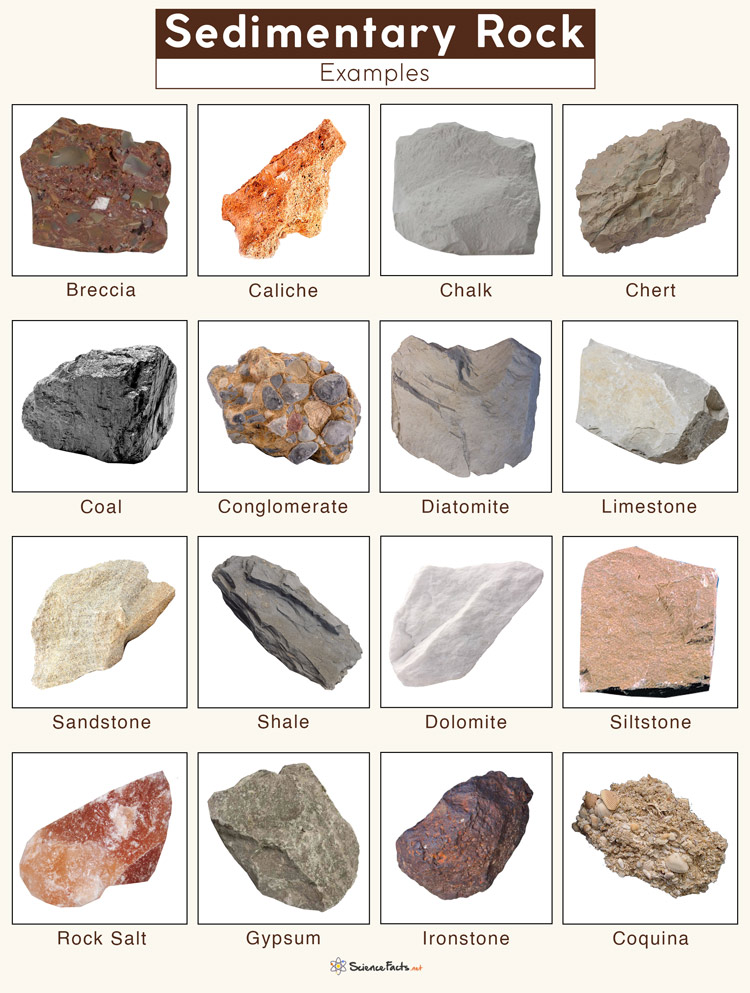
Sedimentary rocks, the silent chroniclers of Earth’s history, are formed from the accumulation and cementation of mineral and organic particles. Their layered structure and fossil content offer invaluable insights into past environments, climates, and the evolution of life. While traditionally studied through hands-on observation and chemical analysis, the modern understanding and identification of sedimentary rocks are increasingly intertwined with sophisticated technological tools and methodologies. This exploration delves into the examples of sedimentary rocks, not just by their geological composition, but through the technological lenses that allow us to uncover their secrets.
The Digital Foundation: Data Acquisition and Analysis Technologies
The journey from raw geological material to a classified sedimentary rock example begins with advanced data acquisition. Technologies that capture the physical and chemical properties of these rocks are fundamental to their identification.
High-Resolution Imaging and Spectroscopy
Modern geological fieldwork and laboratory analysis are heavily reliant on imaging technologies that go far beyond the naked eye. Handheld spectrometers, for instance, can instantly identify the mineralogical composition of a rock sample by analyzing how it interacts with light across various wavelengths. This is particularly crucial for distinguishing between different types of sedimentary rocks, such as the fine-grained argillaceous rocks (shales and mudstones) versus the coarser clastic rocks (sandstones and conglomerates).
Furthermore, drone-mounted hyperspectral imaging systems are revolutionizing the exploration of large sedimentary deposits. These systems capture images in hundreds of narrow spectral bands, allowing geologists to map out variations in mineralogy and rock type across vast landscapes. This data, when processed by specialized software, can reveal subtle differences that might be missed in traditional surveys, aiding in the identification of specific formations and potential resource deposits.
Advanced Microscopy and X-ray Techniques
For detailed examination of sedimentary rock texture and micro-fabric, advanced microscopy plays a pivotal role. Scanning Electron Microscopy (SEM) provides incredibly detailed images of rock surfaces, revealing grain shapes, sizes, and the intricate network of pores and cement. This is essential for understanding the depositional processes and diagenetic alterations that have shaped the rock. Coupled with Energy-Dispersive X-ray Spectroscopy (EDS), SEM can also provide elemental analysis of these microscopic features, offering a precise chemical fingerprint.
X-ray Diffraction (XRD) is another indispensable technological tool. It allows geologists to identify the crystalline mineral phases present in a rock sample by analyzing the diffraction pattern of X-rays as they interact with the crystal lattice. This technique is particularly effective for identifying clay minerals, which are abundant in many sedimentary rocks and can be challenging to identify through other means. The precise mineralogical composition derived from XRD is a cornerstone of accurate sedimentary rock classification.
Geophysical Survey Technologies
Beyond direct sampling, geophysical techniques offer non-invasive methods for identifying and characterizing sedimentary rock formations deep within the Earth’s crust. Seismic surveys, which use sound waves to map subsurface structures, are vital for understanding the geometry and extent of sedimentary basins. By analyzing the travel times and reflections of seismic waves, geologists can infer the presence of different rock layers, their thickness, and their potential for containing hydrocarbons or other resources.
Electrical resistivity and ground-penetrating radar (GPR) are also employed, particularly for shallower sedimentary deposits. These technologies measure variations in electrical conductivity or the reflection of radio waves, respectively, to identify changes in rock type, moisture content, and the presence of subsurface features. The data generated by these geophysical methods are then processed using complex algorithms and visualization software to create detailed geological models.
The Algorithmic Interpreter: Data Processing and Machine Learning
The sheer volume of data generated by these advanced acquisition technologies necessitates sophisticated processing and analytical tools. This is where the power of modern computing and artificial intelligence truly shines in the study of sedimentary rocks.
Big Data Analytics in Stratigraphy
The concept of “big data” is increasingly relevant to sedimentary geology. Large datasets from seismic surveys, well logs, and remote sensing are analyzed using powerful statistical and analytical software. These tools help to identify patterns, correlations, and anomalies that would be impossible to detect manually. For example, geoscientists can use these techniques to correlate rock layers across vast distances, reconstruct ancient depositional environments, and predict the distribution of specific rock types.
Machine learning algorithms are being trained on extensive databases of rock properties, spectral signatures, and seismic responses. These algorithms can then be used to automatically classify rock types from new datasets with remarkable accuracy. For instance, a machine learning model trained on well-log data and core samples can predict the lithology (rock type) of unexplored subsurface intervals, saving significant time and cost in exploration efforts.

AI-Powered Image Recognition for Lithofacies Analysis
Lithofacies, which describe the observable physical characteristics of a sedimentary rock in the field or in hand samples, are critical for understanding depositional environments. Traditionally, identifying lithofacies involved subjective interpretation by experienced geologists. However, AI-powered image recognition systems are transforming this process. These systems are trained on vast libraries of images of sedimentary rocks, learning to identify specific textures, grain sizes, sedimentary structures (like cross-bedding or ripple marks), and color variations that characterize different lithofacies.
This AI-driven approach not only speeds up the analysis but also brings a level of objectivity and consistency to lithofacies identification. It can be applied to images from core samples, outcrop photographs, and even drone imagery, enabling rapid assessment of large geological formations. Examples of sedimentary rocks, such as distinguishing between a poorly sorted conglomerate indicative of a high-energy fluvial environment versus a well-sorted sandstone from a beach setting, become more reliably identifiable through these advanced visual analysis tools.
Predictive Modeling for Resource Exploration
The identification and characterization of sedimentary rocks are directly linked to resource exploration, whether for oil and gas, groundwater, or mineral deposits. Predictive modeling, heavily reliant on computational power and sophisticated algorithms, plays a crucial role. By integrating diverse datasets – including geological maps, well data, seismic attributes, and geochemical analyses – predictive models can identify areas with a high probability of containing valuable resources.
For example, in the search for petroleum, AI algorithms can analyze seismic data to identify geological traps (like anticlines or faults) where hydrocarbons might accumulate. They can also analyze well logs to predict the porosity and permeability of reservoir rocks, key factors for economic viability. This technology-driven approach significantly refines the target areas for exploration, making the process more efficient and less environmentally impactful.
Digital Archives and Virtual Exploration: Accessing and Understanding Examples
The digital revolution has not only transformed how we study sedimentary rocks but also how we access and disseminate knowledge about them. Virtual repositories and interactive platforms are democratizing geological education and research.
Online Databases and Rock Libraries
Numerous online databases and digital rock libraries now host vast collections of information on sedimentary rocks. These resources often include high-resolution images, detailed descriptions, spectral data, and even 3D models of rock samples. Platforms like the U.S. Geological Survey’s National Geochemical Database or university-curated digital rock archives allow researchers and students worldwide to access and study examples of sedimentary rocks without needing physical access to specimens.
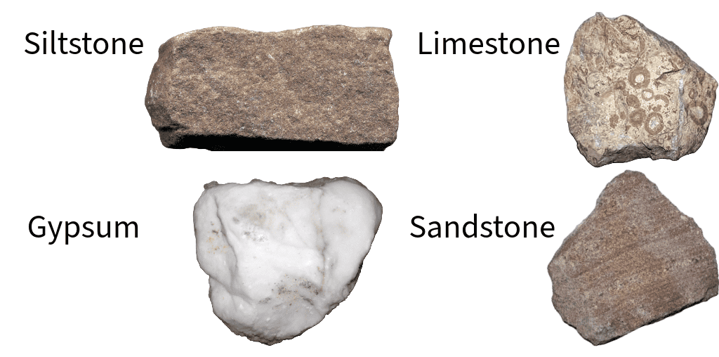
These digital archives are crucial for comparative studies. For instance, a student learning about examples of sedimentary rocks like limestone and sandstone can access detailed entries for each, compare their microscopic textures, and even view their typical stratigraphic occurrences. This accessibility accelerates learning and fosters collaboration among geoscientists globally.
Virtual Field Trips and 3D Reconstruction
The limitations of physical fieldwork, due to accessibility, cost, or environmental concerns, are being overcome by virtual technologies. Virtual field trips, often created using 360-degree photography and immersive environments, allow users to explore geological sites and examine rock formations remotely. These platforms can be annotated with information about the rocks, their formation, and their significance.
Furthermore, advanced 3D reconstruction techniques, using photogrammetry and LiDAR scanning, are creating detailed digital twins of geological outcrops. These models allow for detailed analysis of sedimentary structures, bedding planes, and the relationships between different rock units. This technology is invaluable for documenting and studying important geological sites, including those where specific examples of sedimentary rocks are exposed, providing a rich, interactive learning experience.
Simulation and Modeling of Sedimentary Processes
Beyond identification, technology enables us to simulate the very processes that form sedimentary rocks. Computational fluid dynamics (CFD) can model the transport of sediment by water or wind, helping us understand how grain size and sorting are achieved. Diagenetic simulators can model the chemical and physical changes that rocks undergo after deposition, such as cementation and dissolution.
These simulations allow geologists to test hypotheses about past environments and processes. For instance, by simulating sediment transport under different conditions, researchers can better understand how specific examples of sedimentary rocks, like deltaic sandstones or deep-sea turbidites, were formed. This predictive and explanatory power is a testament to the integration of geological knowledge with advanced computational science.
In conclusion, the study of sedimentary rocks, from the fundamental identification of their varied examples to the complex understanding of their formation and significance, is now profoundly shaped by technology. High-resolution imaging, sophisticated data analysis, machine learning, and virtual exploration tools are not merely aids but integral components of modern sedimentary geology. They empower us to uncover the stories etched in stone, providing unparalleled insights into our planet’s past and its ongoing evolution.
aViewFromTheCave is a participant in the Amazon Services LLC Associates Program, an affiliate advertising program designed to provide a means for sites to earn advertising fees by advertising and linking to Amazon.com. Amazon, the Amazon logo, AmazonSupply, and the AmazonSupply logo are trademarks of Amazon.com, Inc. or its affiliates. As an Amazon Associate we earn affiliate commissions from qualifying purchases.