The sky above us, once a vast and mysterious expanse, is increasingly becoming a bustling arena of technological marvels. From the hum of unseen drones to the silent orbit of satellites, and the invisible pathways carved by commercial aircraft, our overhead world is more crowded and complex than ever before. For many, the question “what’s flying above me?” evokes curiosity, a touch of wonder, and perhaps a hint of concern. This article delves into the technological innovations that are populating our skies, revealing the intricate systems and devices that operate just beyond our immediate sight, transforming everything from global communication to local logistics. We’ll explore the fascinating array of aerial technology, dissecting its applications, the mechanisms behind its operation, and the profound impact it has on our daily lives, all while navigating the evolving landscape of airspace management and ethical considerations. Prepare to look up with new eyes, as we uncover the digital infrastructure and advanced machinery that make the modern sky a vibrant tapestry of human ingenuity.
The Ubiquitous Eye in the Sky: Drones and Their Diverse Applications
Few technologies have captured the public imagination and transformed industries as rapidly as drones. These Unmanned Aerial Vehicles (UAVs), ranging from palm-sized hobbyist gadgets to sophisticated industrial workhorses, have become the most accessible and visible answer to the question of what’s flying overhead. Their versatility stems from their ability to offer aerial perspectives, carry payloads, and operate in environments too dangerous or inaccessible for humans, all controlled either remotely or autonomously through advanced software and GPS.
Commercial Powerhouses: From Delivery to Inspection
The commercial sector has embraced drones with remarkable enthusiasm, recognizing their potential for efficiency and cost-effectiveness. In logistics, companies are pioneering drone delivery services, promising faster package delivery, especially in remote areas or dense urban environments where ground traffic is a constant challenge. Agricultural drones, equipped with multispectral cameras, monitor crop health, assess irrigation needs, and even spray pesticides with precision, optimizing yields and reducing waste. Furthermore, drones have become indispensable tools for infrastructure inspection. From power lines and wind turbines to vast stretches of pipelines and towering bridges, drones can quickly identify structural faults, assess damage, and monitor progress without the need for risky and costly manual inspections, significantly enhancing safety and operational efficiency. The integration of AI for image analysis further automates defect detection, making these aerial inspections incredibly powerful.
Hobbyist’s Delight and Creative Tools
Beyond industrial applications, drones have democratized aerial photography and videography. What once required expensive helicopter rentals and specialized crews can now be achieved with consumer-grade drones, allowing photographers, filmmakers, and enthusiasts to capture breathtaking perspectives and dynamic shots previously unimaginable. The drone racing circuit has also exploded in popularity, showcasing the agility and speed of these devices while pushing the boundaries of remote control technology and pilot skill. For many, flying a drone is simply a captivating hobby, offering a unique way to interact with the environment and develop piloting expertise. These recreational uses often serve as a proving ground for new technologies that eventually trickle up into commercial applications, fostering a vibrant ecosystem of innovation.
Security and Surveillance: Balancing Safety and Privacy
Drones also play a significant role in security and surveillance, offering a cost-effective and flexible alternative to traditional methods. Law enforcement agencies use drones for crowd control, search and rescue operations, accident reconstruction, and monitoring large events. Border patrol units deploy them to cover vast, difficult terrains, while private security firms use them to patrol perimeters and monitor properties. However, this application raises critical questions about privacy and civil liberties. The ability of drones to collect high-resolution imagery and video from a distance necessitates robust regulatory frameworks and ethical guidelines to prevent misuse and ensure public trust. Striking the right balance between enhancing safety and protecting individual privacy remains a key challenge for regulators and technologists alike as drone capabilities continue to advance.
Beyond the Earth’s Embrace: Satellites Shaping Our World
While drones operate within our atmospheric envelope, an even more profound technological presence silently orbits hundreds, or even thousands, of kilometers above us: satellites. These complex machines are not merely isolated entities but form interconnected networks that are fundamental to modern civilization. Designed to perform specific tasks, satellites provide a global infrastructure that underpins everything from accurate timekeeping to instant communication, making them an invisible but indispensable answer to what’s flying above us.
Communication Networks: Bridging Continents and Connecting Devices
Satellites are the backbone of global communication. Geostationary communication satellites, positioned 36,000 kilometers above the equator, provide constant coverage to vast regions, enabling television broadcasting, long-distance phone calls, and internet connectivity, especially in remote areas where terrestrial infrastructure is lacking. More recently, constellations of Low Earth Orbit (LEO) satellites, such as Starlink and OneWeb, are revolutionizing internet access by offering high-speed, low-latency broadband to virtually any location on Earth. These LEO constellations are designed to be highly scalable and provide truly global coverage, bridging the digital divide and connecting billions more people and devices, from IoT sensors to autonomous vehicles, to the global information network.
Earth Observation and Environmental Monitoring
Another critical function of satellites is observing our planet. Earth observation satellites carry sophisticated sensors that collect vast amounts of data about the Earth’s surface, atmosphere, and oceans. This data is invaluable for a myriad of applications, including meteorology (predicting weather patterns, tracking hurricanes), climate science (monitoring sea levels, ice caps, deforestation, and greenhouse gas emissions), and disaster management (assessing damage from floods, wildfires, and earthquakes). Farmers use satellite imagery to monitor crop health, urban planners track city growth, and environmental scientists study ecological changes over time. These “eyes in the sky” provide a holistic and continuous perspective of our planet, offering crucial insights for understanding and managing environmental challenges on a global scale.
GPS and Navigation: Guiding Our Every Step
Perhaps the most pervasive and silently integrated satellite technology into our daily lives is the Global Positioning System (GPS). Developed initially for military use, GPS, and its international counterparts like GLONASS, Galileo, and BeiDou, provide precise location and time information anywhere on Earth. Our smartphones, car navigation systems, fitness trackers, and countless other devices rely on signals from these medium Earth orbit (MEO) satellites to pinpoint our exact position. Beyond personal navigation, GPS is critical for aviation, maritime transport, precision agriculture, surveying, and even banking, where accurate timing is essential for transaction synchronization. The continuous evolution of GPS technology, with enhanced accuracy and reliability, continues to revolutionize how we move, work, and interact with the physical world, making the once-complex act of finding our way an effortless, invisible process.
The Resurgence of Manned and Unmanned Aviation
Beyond the immediate visible presence of drones and the invisible network of satellites, the skies are also home to a more traditional, yet constantly evolving, form of aerial activity: manned and increasingly unmanned aviation. The concept of “what’s flying above me” inherently includes the vast ecosystem of aircraft that crisscross our planet daily, from commercial jets to military platforms and the burgeoning field of urban air mobility. This sector is characterized by continuous innovation in propulsion, aerodynamics, and digital control systems, pushing the boundaries of speed, efficiency, and safety.
Commercial Air Traffic: The Invisible Highways Above

Every day, thousands of commercial flights transport millions of passengers and tons of cargo across continents, forming an intricate network of invisible air highways. These aircraft, powered by advanced turbofan engines, rely on sophisticated avionics, air traffic control (ATC) systems, and a global network of radars and communication protocols to navigate safely and efficiently. The evolution of commercial aviation has been a story of continuous technological advancement, from the introduction of jet engines to fly-by-wire controls and advanced automation in cockpits. Modern aircraft are marvels of engineering, integrating complex sensor suites, real-time weather mapping, and satellite-based navigation systems to ensure precise flight paths and minimize delays, all while adhering to rigorous international safety standards. The sheer volume and complexity of this coordinated movement underscore the critical role of technology in managing our busiest airspace.
Urban Air Mobility (UAM) and the Future of Commuting
The next frontier in manned (and eventually unmanned) aviation is Urban Air Mobility (UAM), a vision of a future where electric vertical takeoff and landing (eVTOL) aircraft provide on-demand air transportation within and between cities. Companies are investing heavily in developing “air taxis” or “flying cars” that could alleviate ground traffic congestion and offer a new mode of rapid, efficient travel. These aircraft leverage advanced battery technology, distributed electric propulsion, and sophisticated autonomous flight systems to operate safely in complex urban environments. While still in its nascent stages, UAM promises to transform city planning, commuter habits, and logistics. The technological challenges include developing robust autonomous navigation, ensuring battery longevity and rapid charging, and, crucially, integrating these new vehicles safely into existing airspace while establishing new regulatory frameworks. The prospect of air taxis becoming a common sight above our cities represents a significant leap in how we conceive of personal and public transportation.
Military Aviation and Advanced Surveillance Platforms
On a different scale of technology and purpose, military aviation continues to push the absolute limits of aerospace engineering. Stealth aircraft, hypersonic jets, and advanced drone platforms represent the pinnacle of current aerial technology. These machines incorporate state-of-the-art materials, advanced radar evasion techniques, sophisticated electronic warfare systems, and highly integrated artificial intelligence for mission planning and execution. Surveillance aircraft, both manned and unmanned, are equipped with powerful sensors – radar, infrared, electro-optical – capable of monitoring vast areas with incredible detail, providing critical intelligence and situational awareness. The development of advanced airborne early warning and control (AEW&C) systems further enhances air defense capabilities by providing comprehensive views of airspace. The relentless pursuit of superior air power continues to drive innovation in areas such as propulsion, materials science, avionics, and autonomous control, with many military advancements eventually finding their way into civilian applications.
Tracking the Unseen: Technologies for Airspace Awareness
While the sight of a plane or the sound of a drone is obvious, the majority of what’s flying above us operates beyond our direct sensory perception. Understanding “what’s flying above me” often requires dedicated technological tools that extend our awareness beyond the visual horizon. These technologies are crucial not only for curious citizens but are absolutely vital for air traffic controllers, pilots, and security personnel who must maintain a comprehensive, real-time picture of everything in the sky.
Flight Tracking Apps and ADS-B Technology
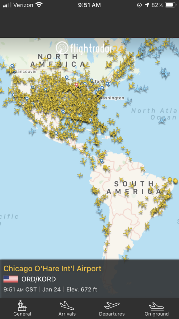
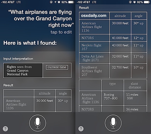
For the casual observer, flight tracking apps like FlightAware or Flightradar24 have demystified commercial air traffic, allowing anyone with a smartphone to see in real-time what aircraft are overhead, their origin, destination, and altitude. These apps primarily rely on Automatic Dependent Surveillance-Broadcast (ADS-B) technology. ADS-B equipped aircraft regularly broadcast their GPS position, altitude, speed, and other data to ground stations and other aircraft. This unencrypted data is then collected by a global network of volunteer and commercial receivers, aggregated, and displayed visually on maps. ADS-B offers a more accurate and frequent update than traditional radar, enhancing airspace safety and providing unprecedented transparency into air traffic movements, giving individuals a direct window into the aerial ballet above them.
Radar Systems and Air Traffic Control Evolution
The foundation of modern air traffic control (ATC) has historically been radar. Primary radar systems emit radio waves that bounce off aircraft, returning echoes that reveal an aircraft’s position and speed. Secondary surveillance radar (SSR) interrogates transponders on aircraft, which then broadcast identifying information and altitude, providing more specific data. These radar networks form the backbone of ATC, allowing controllers to safely guide aircraft through congested airspace and manage thousands of movements daily. However, radar has limitations, including coverage gaps and the need for line-of-sight. The evolution of ATC is increasingly moving towards a satellite-based system, often integrating ADS-B data, which offers global coverage and greater precision, reducing reliance on ground-based radar, especially over oceans and remote areas. This shift represents a fundamental change in how airspace is managed, moving towards a more efficient and globally integrated system.
AI and Machine Learning in Airspace Management
The sheer volume and complexity of aerial activity, particularly with the proliferation of drones and the advent of UAM, are pushing traditional human-centric ATC systems to their limits. This is where Artificial Intelligence (AI) and Machine Learning (ML) are stepping in. AI algorithms can analyze vast datasets from radar, ADS-B, weather patterns, and flight plans to predict potential conflicts, optimize flight paths, and recommend adjustments to controllers in real-time. ML models can identify anomalous flight patterns that might indicate security threats or unauthorized drone activity. Furthermore, AI is crucial for developing Unmanned Aircraft System Traffic Management (UTM) systems, which will be necessary to safely integrate large numbers of autonomous drones into low-altitude airspace, preventing collisions and managing dynamic flight routes. These intelligent systems promise to enhance safety, improve efficiency, and make the future of a crowded sky manageable, ensuring that “what’s flying above me” can be precisely identified and tracked at all times.
Navigating the Ethical and Regulatory Skies
As technology continues to populate our skies with an increasing array of devices and vehicles, the benefits are undeniable. However, this rapid advancement also introduces significant challenges related to ethics, privacy, and regulation. The question of “what’s flying above me” isn’t just about identification; it’s also about responsibility, legality, and the broader societal implications of pervasive aerial technology. Striking a balance between fostering innovation and safeguarding public interest is paramount for the sustainable growth of our aerial future.
Data Privacy and Surveillance Concerns
The proliferation of drones equipped with high-resolution cameras, thermal imagers, and other sensors, combined with the extensive data collected by satellites, raises significant data privacy concerns. Who owns the data collected by these devices? How is it stored, shared, and used? The ability of drones to capture images and videos of private property or individuals without their consent can lead to privacy infringements and potential misuse of information. Similarly, advanced satellite imagery can reveal highly detailed information about land use, infrastructure, and even individual activities. Robust legal frameworks are needed to define what constitutes legitimate data collection, how data must be protected, and what rights individuals have regarding imagery or information captured from above. Public trust in aerial technology hinges on the industry’s and regulators’ ability to address these privacy challenges transparently and effectively.
Airspace Regulations and the Challenge of Integration
Historically, airspace has been highly regulated, primarily for manned aviation. However, the advent of drones has introduced a new class of aircraft that challenges existing regulatory structures. Integrating millions of small, often autonomous, drones into airspace alongside traditional aircraft without compromising safety is a monumental task. Governments worldwide are grappling with establishing clear rules for drone registration, pilot licensing, flight restrictions (no-fly zones), and operational procedures. The development of Unmanned Traffic Management (UTM) systems, which are essentially air traffic control systems specifically for drones, is critical for managing dense drone traffic, preventing collisions, and ensuring accountability. As Urban Air Mobility (UAM) emerges, further regulations will be needed to govern eVTOL operations, including noise limits, landing infrastructure, and public safety protocols. The fragmented nature of international airspace regulation also presents challenges, demanding greater global cooperation to create a harmonized and safe aerial environment.
Sustainable Aviation and Future Innovations
Beyond safety and privacy, the environmental impact of increased aerial activity is a growing concern. While drones are often electric, the vast commercial aviation industry is a significant contributor to carbon emissions. The future of aviation, both manned and unmanned, must prioritize sustainability. This involves developing more fuel-efficient aircraft, exploring alternative fuels like sustainable aviation fuel (SAF) and hydrogen, and accelerating the transition to electric and hybrid-electric propulsion for shorter-haul flights and UAM. Research into quieter drone designs and operational procedures that minimize noise pollution is also crucial for urban integration. Looking ahead, innovations in autonomous flight, AI-powered predictive maintenance, and advanced materials will not only enhance safety and efficiency but also contribute to making air travel and aerial operations more environmentally friendly. The long-term viability of our increasingly crowded skies depends on our ability to innovate responsibly, ensuring that the technology flying above us contributes positively to society without compromising our planet.
The answer to “what’s flying above me” is no longer simple. It is a complex, ever-evolving tapestry woven from the threads of cutting-edge technology. From the localized buzz of a drone to the silent, global reach of a satellite, and the seamless transit of commercial jets, our skies are a testament to human ingenuity and ambition. These aerial advancements are not just feats of engineering; they are integral components of our modern infrastructure, impacting communication, commerce, security, and our understanding of the planet. As we move forward, the challenge lies in harmonizing this technological surge with ethical considerations, robust regulations, and a commitment to sustainability. By embracing these challenges, we can ensure that the skies above us remain a realm of wonder, innovation, and progress, safely serving the needs of humanity for generations to come.
aViewFromTheCave is a participant in the Amazon Services LLC Associates Program, an affiliate advertising program designed to provide a means for sites to earn advertising fees by advertising and linking to Amazon.com. Amazon, the Amazon logo, AmazonSupply, and the AmazonSupply logo are trademarks of Amazon.com, Inc. or its affiliates. As an Amazon Associate we earn affiliate commissions from qualifying purchases.