The Amazon rainforest, a biome of unparalleled biodiversity and ecological significance, has captivated humanity for centuries. Its sheer scale is legendary, often described as the “lungs of the Earth” or a “living superorganism.” Yet, to truly grasp “how big is the Amazon jungle” in a quantifiable, up-to-date, and actionable sense is a monumental challenge that transcends traditional cartography. In an era defined by data and digital innovation, understanding the Amazon’s vastness—and its dynamic changes—is increasingly a testament to technological prowess. From orbiting satellites to sophisticated AI algorithms, a suite of advanced tools allows scientists, conservationists, and governments to measure, map, and monitor this colossal natural wonder with unprecedented precision. This technological lens is not just about producing numbers; it’s about providing the critical intelligence needed to protect and preserve one of our planet’s most vital ecosystems.
Mapping the Giant: The Evolution of Geographic Information Systems (GIS)
For centuries, the task of mapping the Amazon was an arduous, often perilous undertaking, relying on ground expeditions and limited aerial surveys. The advent of Geographic Information Systems (GIS) revolutionized this process, transforming how we compile, analyze, and visualize spatial data for regions as expansive and complex as the Amazon. GIS provides the foundational framework upon which much of our current understanding of the jungle’s size and structure is built.
From Cartography to Digital Layers: Early Advances in GIS
The initial applications of GIS in the Amazon basin marked a paradigm shift from static paper maps to dynamic digital representations. Early GIS tools allowed researchers to digitize existing geographical data, integrating topographical maps, hydrological networks, and rudimentary land-use classifications into a unified digital environment. This meant that instead of distinct maps for rivers, elevations, or forest cover, all this information could be overlaid and analyzed simultaneously. These early systems enabled the first comprehensive digital inventories of the Amazon’s vast area, offering a more precise estimate of its total extent than ever before possible. They also allowed for the spatial correlation of different datasets, such as linking soil types to specific vegetation patterns, paving the way for more complex ecological modeling. The ability to query and manipulate this data digitally significantly accelerated research and opened new avenues for understanding the spatial relationships within the rainforest.
Precision and Integration: Modern GIS Capabilities
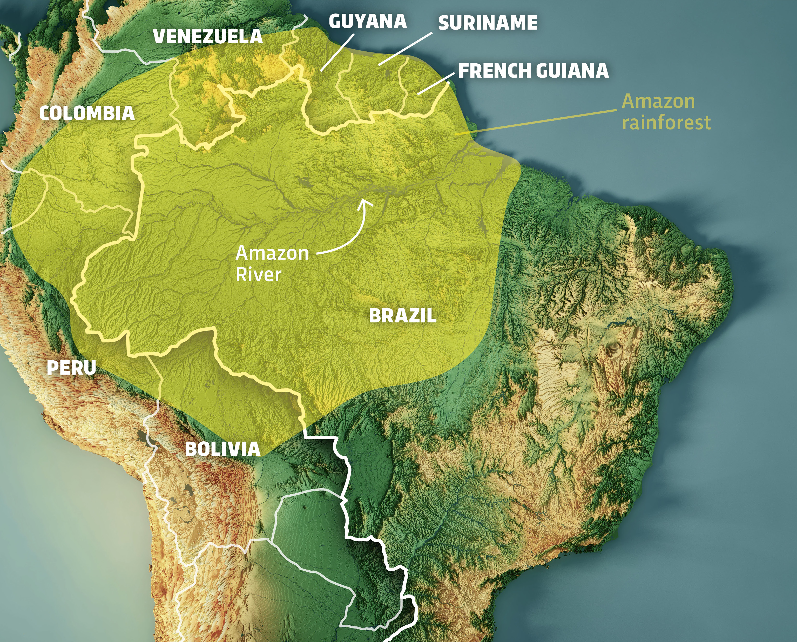
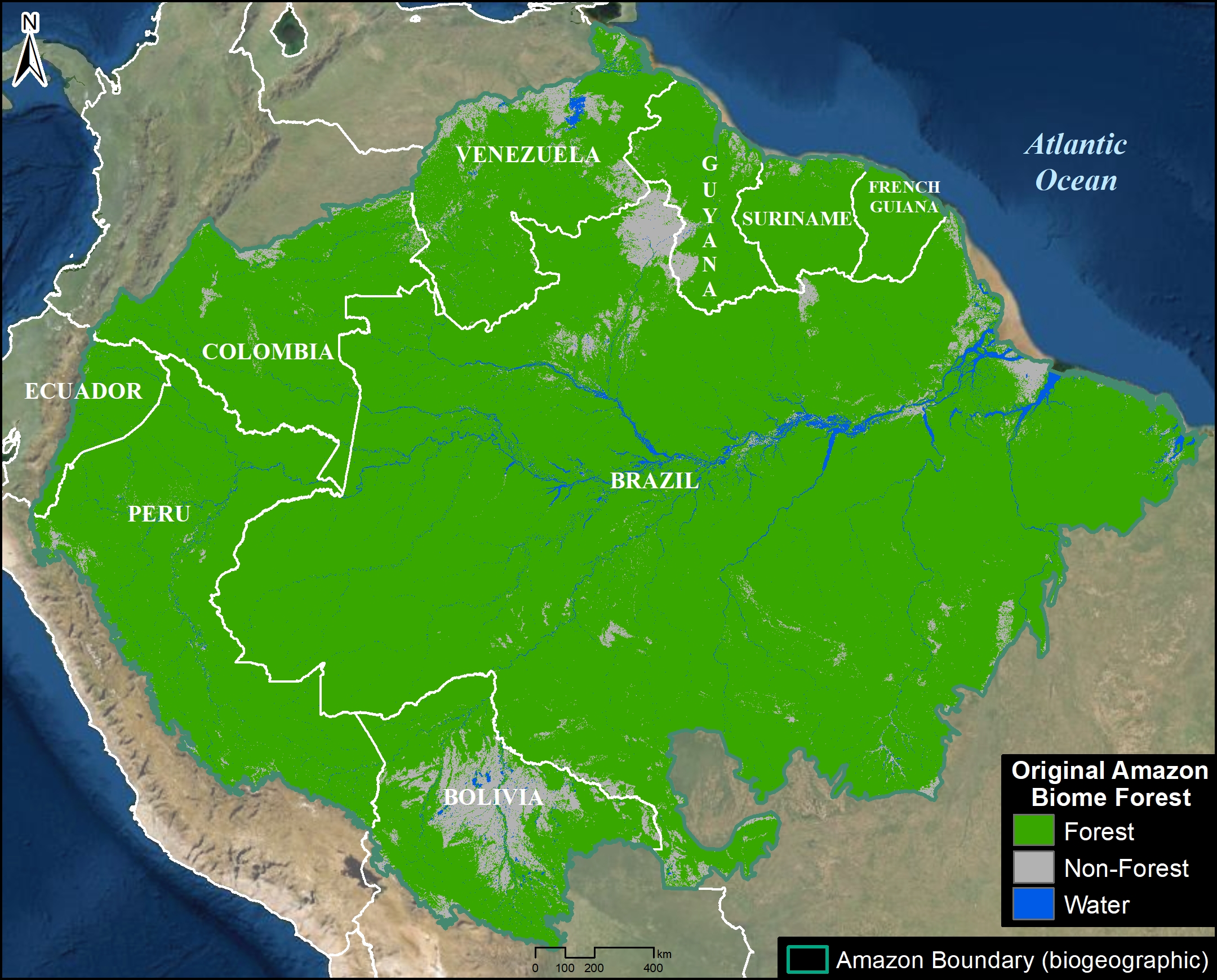
Today’s GIS platforms are far more sophisticated, acting as powerful engines for spatial analysis and data integration. They can process vast amounts of real-time data from various sources, including high-resolution satellite imagery, GPS coordinates from field surveys, and sensor data on environmental conditions. Modern GIS allows for the creation of intricate multi-layered maps that depict not only the total geographical extent of the Amazon but also its intricate details: canopy density, specific forest types, human settlements, agricultural expansion, and protected areas. These systems are critical for defining the exact boundaries of the Amazon basin, which spans nine South American countries. Furthermore, advanced GIS tools incorporate complex algorithms for terrain analysis, hydrological modeling, and change detection, enabling scientists to visualize and quantify even subtle shifts in the landscape. This integration provides a holistic, dynamic view of the Amazon’s “size” – not just a static area, but a living, evolving entity defined by its constantly changing internal dynamics.
Eyes in the Sky: Satellite Imagery and Remote Sensing
If GIS provides the framework, then satellite imagery and remote sensing are the eyes that deliver the continuous stream of data needed to populate that framework. Given the Amazon’s immense size and often inaccessible terrain, direct ground-based measurement is impractical for comprehensive monitoring. Satellites offer an unparalleled vantage point, providing regular, wide-area coverage that is essential for understanding the jungle’s true extent and the myriad processes occurring within it.
Unveiling the Canopy: Types of Satellite Data
The question “how big is the Amazon jungle” is not just about total square kilometers; it’s also about the volume, density, and health of its forest cover. Various types of satellite data are employed to capture these multifaceted aspects. Optical satellites, like those in the Landsat and Sentinel missions, provide high-resolution visual imagery that helps delineate forest boundaries, identify different vegetation types, and detect clearings. Synthetic Aperture Radar (SAR) satellites, such as those from the PALSAR and TerraSAR-X programs, are particularly valuable because they can penetrate cloud cover and even some vegetation, providing data regardless of weather conditions. This is crucial for the perennially cloudy Amazon, allowing for consistent monitoring. LiDAR (Light Detection and Ranging) technology, deployed on some satellite missions and increasingly on airborne platforms, measures vertical forest structure, providing critical data on canopy height and biomass – adding a third dimension to our understanding of the jungle’s “size” and carbon storage capacity. The fusion of these different data types paints a richer, more accurate picture of the Amazon than any single source could provide.
Detecting Change: Monitoring Deforestation and Reforestation
The Amazon’s “size” is not static; it is constantly threatened by deforestation and, in some areas, supported by reforestation efforts. Satellite imagery is the primary tool for real-time monitoring of these changes. Algorithms analyze time-series satellite images to automatically detect new areas of deforestation, fires, and illegal mining operations. Platforms like DETER (Deforestation Detection in Real Time) in Brazil use daily satellite passes to identify deforestation alerts, providing crucial data to environmental agencies for rapid intervention. Similarly, satellite data helps track the regrowth of forests, quantifying the success of restoration projects and natural regeneration. This dynamic monitoring capability allows scientists and policymakers to quantify the rate of forest loss or gain, directly impacting the answer to “how big is the Amazon jungle” at any given moment. It transitions the concept of size from a fixed measurement to a continuous, evolving metric, highlighting areas of vulnerability and resilience across the vast basin.

Beyond Pixels: Artificial Intelligence and Big Data Analytics
While satellites gather the raw data and GIS organizes it, the sheer volume of information generated by continuous monitoring necessitates even more advanced technological solutions. This is where Artificial Intelligence (AI) and big data analytics come into play, transforming raw imagery and sensor readings into actionable insights with unprecedented speed and scale.
Automated Detection: AI for Pattern Recognition
The human eye simply cannot process the petabytes of satellite imagery generated daily. AI, particularly machine learning and deep learning algorithms, excels at this task. These algorithms are trained on vast datasets of labeled images (e.g., areas identified as deforested, intact forest, or river systems) to automatically recognize patterns and classify land cover types with high accuracy. AI can swiftly identify subtle changes indicative of illegal logging roads, small clearings, or new agricultural encroachments that might be missed by manual inspection. Furthermore, AI-powered systems can distinguish between natural forest disturbances (like tree falls) and human-induced deforestation, providing a more nuanced understanding of change. This automated detection significantly enhances the efficiency of monitoring, allowing conservationists to focus resources on verified threats and providing up-to-the-minute statistics on the true extent and health of the Amazon.
Predictive Modeling: Forecasting Environmental Shifts
Beyond mere detection, AI and big data analytics enable sophisticated predictive modeling. By analyzing historical trends in deforestation, climate data, socio-economic indicators, and infrastructure development, AI models can forecast future deforestation hotspots or areas at high risk of fire. These models consider complex interactions between various factors, such as proximity to roads, population density, and market demand for agricultural products. This predictive capability is invaluable for proactive conservation strategies, allowing governments and NGOs to implement preventative measures before widespread damage occurs. For example, by identifying regions with high deforestation risk, resources can be deployed to strengthen law enforcement, promote sustainable land practices, or establish new protected areas. This foresight fundamentally shifts the approach to understanding the Amazon’s “size” from merely reactive measurement to proactive management, anticipating future states of this critical ecosystem.
The Digital Frontier: Emerging Technologies and Future Outlook
The technological toolkit for understanding the Amazon is continually evolving. New innovations promise even greater precision, transparency, and engagement, moving beyond traditional remote sensing to incorporate localized data and decentralized platforms. These emerging technologies are poised to provide an even more granular and robust answer to “how big is the Amazon jungle,” and crucially, how we can collectively protect it.
Drone Technology: Hyper-Local Insights
While satellites offer broad coverage, drones provide an invaluable hyper-local perspective. Equipped with high-resolution cameras, thermal sensors, and even LiDAR, drones can capture incredibly detailed data over specific areas, offering insights that satellite imagery might miss. They are used for monitoring small-scale illegal logging, tracking wildlife populations, assessing the health of specific forest patches, and overseeing reforestation projects with unparalleled detail. Drones can navigate dense canopy, access remote riverine areas, and provide frequent, on-demand aerial surveillance. This localized data complements the broader satellite picture, allowing for more precise interventions and detailed assessment of specific ecosystem components, adding another layer of depth to our understanding of the Amazon’s “size” and micro-environments.
Blockchain and Transparency: Tracking Conservation Efforts
The financial and logistical complexities of Amazonian conservation often face challenges of transparency and accountability. Blockchain technology offers a novel solution by creating immutable, decentralized ledgers. This could be used to transparently track funding for conservation projects, verify carbon credit transactions, or even trace the origin of sustainable products from the Amazon to combat illegal trade. For instance, a blockchain-powered system could certify that timber originated from sustainably managed forests, providing an auditable trail that reassures consumers and rewards responsible practices. By enhancing transparency and trust, blockchain can indirectly support the integrity of the Amazon’s protected areas and sustainable economic zones, helping to preserve its “size” and ecological value by fostering more effective and honest conservation efforts.
Conclusion
The question “how big is the Amazon jungle” is far more complex than a simple number. It’s a dynamic query whose answer is continuously refined and expanded by the relentless march of technological innovation. From the foundational layers of GIS that organize spatial data to the ubiquitous eyes of satellites that capture its every shift, and from the intelligent algorithms of AI that interpret vast datasets to the emerging frontiers of drones and blockchain, technology is proving indispensable. It provides not just an increasingly precise measurement of the Amazon’s geographical extent, but a multidimensional understanding of its biological complexity, ecological processes, and the threats it faces. By leveraging these powerful tools, humanity gains the intelligence needed to not only quantify the Amazon’s size but, more importantly, to safeguard its future as an irreplaceable global treasure. The ongoing digital revolution empowers us with the clarity and foresight required to ensure that this magnificent jungle continues to thrive, remaining “big” in every sense of the word for generations to come.
aViewFromTheCave is a participant in the Amazon Services LLC Associates Program, an affiliate advertising program designed to provide a means for sites to earn advertising fees by advertising and linking to Amazon.com. Amazon, the Amazon logo, AmazonSupply, and the AmazonSupply logo are trademarks of Amazon.com, Inc. or its affiliates. As an Amazon Associate we earn affiliate commissions from qualifying purchases.