For decades, looking up at a silver speck trailing a white vapor path across the blue sky prompted a simple, unanswerable question: “I wonder where that plane is going?” Today, that mystery has been solved by the democratization of sophisticated surveillance technology. Through a combination of global positioning systems, terrestrial receiver networks, and high-performance mobile applications, the “invisible” highways of the sky have been mapped in real-time for anyone with a smartphone.
The ability to answer “what airplanes are above me” is not merely a novelty for aviation enthusiasts; it is a testament to the massive leaps in Software as a Service (SaaS), hardware miniaturization, and data processing. To understand how we identify a Boeing 787 cruising at 35,000 feet with a single tap, we must look at the intricate tech stack powering the modern digital sky.
The Engine Behind the Screen: How ADS-B Technology Works
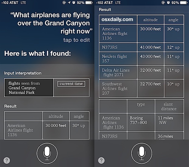
At the heart of modern flight tracking is a technology known as Automatic Dependent Surveillance-Broadcast, or ADS-B. This is the foundational tech that has replaced traditional primary radar—which relies on radio waves bouncing off a physical object—with a more precise, data-driven approach.
Understanding ADS-B Out vs. ADS-B In
ADS-B “Out” is the transmitter side of the equation. Most modern aircraft are equipped with a transponder that periodically broadcasts the aircraft’s GPS location, altitude, airspeed, and identification information. Unlike traditional radar, which requires a ground station to “paint” the sky to find a target, ADS-B Out proactively sends this data into the atmosphere on a frequency of 1090 MHz.
ADS-B “In” refers to the receivers on the ground or in other aircraft that “hear” these broadcasts. The tech community has played a massive role here; thousands of hobbyists around the world use inexpensive Raspberry Pi computers paired with Software Defined Radio (SDR) dongles to capture these signals. These individual nodes then feed their localized data into massive centralized clouds, creating the comprehensive global maps we see on our screens.
The Role of Satellite Navigation (GNSS)
For ADS-B to function, the aircraft must first know exactly where it is. This is achieved through Global Navigation Satellite Systems (GNSS), such as GPS. The aircraft’s onboard computer integrates satellite data to determine its three-dimensional coordinates with high precision. This reliance on satellite tech ensures that even over remote areas, an aircraft’s position is calculated with far greater accuracy than the old-school ground-based “sweeping” radar could ever manage.
Top Flight Tracking Software and Apps for 2024
While the hardware gathers the data, it is the software layer that makes the information accessible and readable. Several tech companies have emerged as leaders in processing billions of data points per second to provide a seamless user experience.
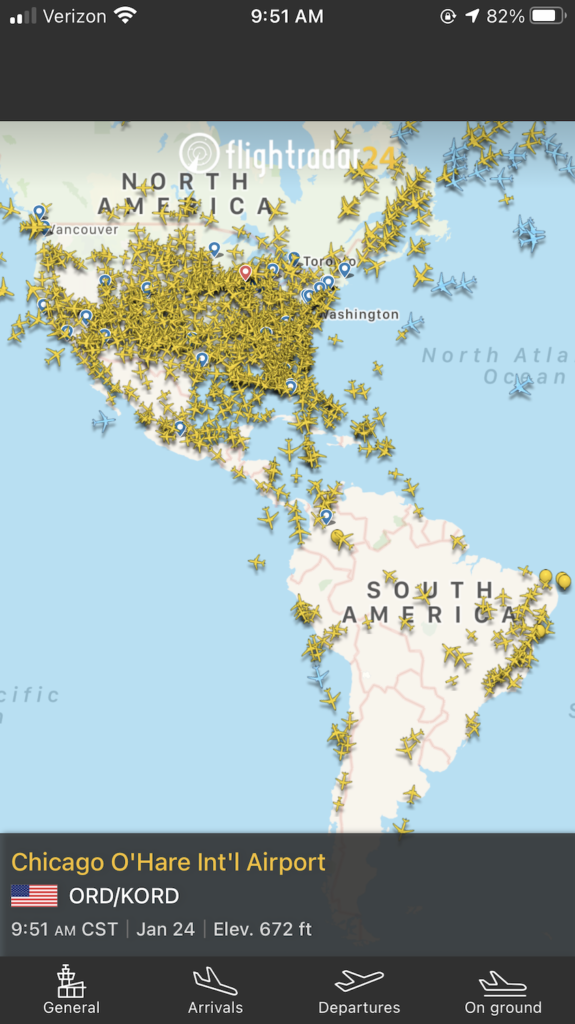
Flightradar24: The Industry Standard
Flightradar24 is perhaps the most recognizable name in the niche. Its success lies in its massive proprietary network of over 30,000 terrestrial receivers. From a software perspective, Flightradar24 excels in UI/UX design, transforming raw hexadecimal code into a beautiful, interactive 2D or 3D map. Its “Filter” technology allows users to isolate specific aircraft types, altitudes, or airlines, demonstrating high-level database management that remains responsive even during peak traffic hours when over 20,000 aircraft might be in the air simultaneously.
FlightAware: Precision Data for Professionals
While Flightradar24 focuses on the enthusiast, FlightAware provides a more data-centric approach often used by logistics companies and airport operators. Their “HyperFeed” engine is a marvel of software engineering; it aggregates data from ADS-B, land-based radar, and satellite-link providers to provide a predictive model of flight paths. This allows the app to estimate arrival times with uncanny accuracy, accounting for weather patterns and air traffic control (ATC) holding patterns that might not be immediately visible through raw location data.
ADS-B Exchange: The Unfiltered Alternative
In the world of tech purists, ADS-B Exchange is often the preferred tool. Unlike commercial competitors, it does not filter out “blocked” aircraft—such as private jets belonging to high-profile figures or military transport. It operates as a co-op, relying entirely on a decentralized network of feeders. Its interface is less “polished” but provides a raw, unfiltered look at the sky, serving as a vital tool for digital investigators and data journalists.
The Magic of Augmented Reality (AR) in Aviation
The most impressive technological leap in answering “what is above me” is the integration of Augmented Reality (AR). This tech bridges the gap between the physical world and digital data, allowing a user to point their phone’s camera at the sky and see a digital overlay of the aircraft’s details.
Identifying Planes with Your Smartphone Camera
The AR view in flight-tracking apps is a masterclass in sensor fusion. To work correctly, the software must simultaneously access the phone’s camera, its GPS for location, its magnetometer for heading, and its gyroscope for tilt. The app then calculates the user’s “field of view” and cross-references it with the real-time database of aircraft positions. When you see a label “stick” to a plane through your camera lens, the software is performing complex trigonometric calculations in real-time to ensure the digital tag aligns with the moving physical object.
Sensor Fusion: Integrating GPS, Gyroscopes, and Data Streams
The challenge of AR in this context is latency. Because a plane might be moving at 500 mph, even a half-second delay in data processing can cause the digital tag to lag behind the aircraft. Tech developers use “Dead Reckoning” algorithms to solve this. These algorithms predict where the plane will be in the next few milliseconds based on its last known velocity and heading, ensuring the overlay remains smooth and anchored to the visual target.
Privacy, Security, and the Digital Sky
As with any technology that involves surveillance and data broadcasting, the rise of flight tracking has sparked significant debates regarding digital security and privacy.
The Debate Over Private Jet Tracking
From a software standpoint, every aircraft has a unique 24-bit ICAO address. This is essentially its digital fingerprint. While commercial airlines have no expectation of privacy, many private owners argue that their movements should be shielded. This has led to the development of the “Privacy ICAO Address” (PIA) program, where the FAA allows operators to use a temporary, randomized digital identity. However, tech-savvy “planespotters” often use Multilateration (MLAT)—a technique that calculates a position by measuring the time difference of arrival of a signal at different receivers—to unmask these anonymous flights.
Cybersecurity Risks in Aviation Transmissions
A significant concern within the tech community is that ADS-B signals are unencrypted and unauthenticated. This means that, in theory, a sophisticated actor could “spoof” a signal, creating a “ghost plane” on a controller’s or hobbyist’s screen. While the aviation industry relies on multiple redundant systems (like primary radar and TCAS) to ensure safety, the lack of encryption in the ADS-B protocol is an ongoing topic for cybersecurity researchers looking at the next generation of aerospace communication.
The Future of Air Traffic Monitoring: AI and ML Integration
The next frontier for flight tracking technology is the shift from “descriptive” data (where is the plane now?) to “predictive” data (what will the plane do next?). This is where Artificial Intelligence (AI) and Machine Learning (ML) are taking center stage.
Predictive Analytics for Flight Delays
By training ML models on years of historical flight data, weather patterns, and airport congestion metrics, tech platforms are becoming incredibly good at predicting delays before they are even announced by the airline. If the software detects a specific pattern of “S-turns” or a decrease in airspeed miles away from an airport, it can automatically alert users to a likely holding pattern, providing a level of foresight that was previously only available to air traffic controllers.

Enhancing Safety with Automated Anomaly Detection
AI is also being used to monitor the “health” of the sky. Software can now be programmed to detect “anomalous” flight behavior—such as a sudden change in altitude or a deviation from a filed flight plan—faster than a human monitor could. These AI tools provide an extra layer of digital security, flagging potential emergencies or security breaches in real-time by analyzing the velocity and trajectory of thousands of aircraft simultaneously.
The simple act of looking up and identifying a plane is now supported by a global infrastructure of satellites, ground receivers, and advanced software. Whether through AR overlays, decentralized data networks, or AI-driven predictions, the technology behind flight tracking has turned the sky into a transparent, data-rich environment. As these tools continue to evolve, the gap between the ground and the cockpit will only continue to shrink, making the world above us more accessible than ever before.
aViewFromTheCave is a participant in the Amazon Services LLC Associates Program, an affiliate advertising program designed to provide a means for sites to earn advertising fees by advertising and linking to Amazon.com. Amazon, the Amazon logo, AmazonSupply, and the AmazonSupply logo are trademarks of Amazon.com, Inc. or its affiliates. As an Amazon Associate we earn affiliate commissions from qualifying purchases.