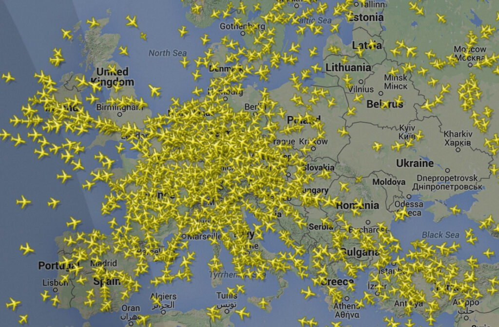
At any given moment, the sky above us is a buzzing hive of mechanical activity. While we see only a blue expanse or a blanket of clouds from the ground, the digital layer of our atmosphere is densely populated. On average, there are between 8,000 and 20,000 planes in the air at any single point in time, depending on the time of day and the season. But how do we know this number with such precision?
The ability to answer the question “how many planes are in the air right now” is not the result of a simple headcount. It is the culmination of a sophisticated global technological ecosystem that combines hardware, satellite communications, big data processing, and open-source communities. From ADS-B transponders to cloud-based visualization engines, the technology behind flight tracking has transformed from a secretive military tool into a transparent, real-time data utility accessible to anyone with a smartphone.
The Hardware Foundation: ADS-B and the Rise of Modern Surveillance
The backbone of modern flight tracking is a technology known as Automatic Dependent Surveillance–Broadcast (ADS-B). For decades, air traffic control (ATC) relied primarily on primary radar—sending out a radio signal and waiting for it to bounce off an object. While effective, primary radar provides limited information and struggles with accuracy over long distances. ADS-B changed the paradigm by making the aircraft an active participant in its own tracking.
ADS-B: The Core Transmission Protocol
Unlike traditional radar, ADS-B is “automatic” because it requires no pilot intervention and “dependent” because it relies on data from the aircraft’s navigation system. Every few seconds, a plane equipped with an ADS-B Out transponder broadcasts its GPS position, altitude, airspeed, and a unique identification code over the 1090 MHz frequency. This digital “heartbeat” is unencrypted, allowing any receiver within range to capture the data. This transparency is the primary reason why consumer apps can show you exactly where a flight is in real-time.
Ground-Based Receiver Networks
While the signal is broadcast by the plane, it must be captured by a receiver. Tech-centric platforms like Flightradar24 and FlightAware have built massive global networks consisting of tens of thousands of ground stations. Many of these stations are hosted by hobbyists using inexpensive hardware like Raspberry Pi computers and specialized RTL-SDR (Software Defined Radio) dongles. This decentralized “crowdsourced” approach to hardware allows for granular coverage in areas where official government radar might be sparse.
MLAT: Calculating the Position of Older Aircraft
Not every aircraft is equipped with the latest ADS-B technology. For older planes or those with legacy transponders (Mode S), tracking companies employ a technique called Multilateration (MLAT). By measuring the Time Difference of Arrival (TDOA) of a signal at four or more different ground stations, sophisticated algorithms can triangulate the aircraft’s exact position. This requires high-precision clock synchronization across the receiver network, showcasing the complex interplay between hardware timing and software processing.
Data Processing at Scale: From Raw Signals to Actionable Insights
Capturing a signal is only the first step. The sheer volume of data generated by 20,000 aircraft broadcasting multiple times per second creates a massive “Big Data” challenge. Converting raw radio waves into a smooth, moving icon on a digital map requires a robust software pipeline and significant cloud computing power.
The Aggregation Engine
When thousands of ground stations receive a signal from the same aircraft, the central servers receive redundant data. The software backend must de-duplicate these signals, verify their integrity, and merge them into a single “source of truth” for that specific flight. This happens in milliseconds. Modern flight tracking platforms use distributed computing architectures and stream-processing frameworks (like Apache Kafka or Spark) to handle these high-velocity data feeds without lag.
Normalizing Global Datasets
Flight data doesn’t just come from ADS-B receivers. To provide a complete picture, tech platforms must integrate data from various sources:
- FAA SWIM Feeds: The Federal Aviation Administration’s System Wide Information Management (SWIM) provides official flight plans and North American radar data.
- EUROCONTROL: Provides similar official data for European airspace.
- Airline Schedules: To link a “tail number” to a specific flight number (e.g., DAL123), the system must cross-reference real-time signals with massive databases of airline schedules and historical flight paths.
Predictive Modeling and Dead Reckoning
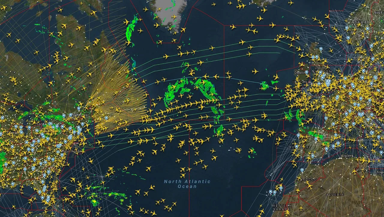
What happens when a plane flies over the ocean, out of range of ground stations? This is where software takes over. Using “dead reckoning” algorithms, the system predicts the plane’s position based on its last known speed, heading, and altitude. More advanced systems now integrate satellite-based ADS-B, where receivers placed on Low Earth Orbit (LEO) satellites capture signals from above, ensuring that even in the middle of the Atlantic, the “planes in the air” count remains accurate.
The Consumer Interface: Visualizing the Global Fleet
The most visible part of this technology stack is the User Interface (UI). Transforming millions of data points into an interactive map that can run on a mobile browser is a significant feat of front-end engineering.
High-Performance Map Rendering
Displaying 15,000 moving objects simultaneously would crash a standard web browser if not handled correctly. Developers use WebGL (Web Graphics Library) to offload the rendering of aircraft icons to the user’s Graphics Processing Unit (GPU). This allows for smooth zooming and panning across a globe cluttered with data. Each icon is not just a static image but a data-rich object that, when clicked, pulls from an API to show the aircraft’s type, age, vertical speed, and even its past flight history.
Augmented Reality (AR) Integration
One of the most impressive recent tech trends in this niche is the integration of Augmented Reality. By combining a smartphone’s GPS, accelerometer, and camera, flight-tracking apps can overlay flight data onto the “live” sky. When a user points their phone at a plane in the distance, the software calculates the user’s line of sight and matches it against the real-time database of aircraft positions. This is a perfect example of “sensor fusion,” where multiple hardware inputs are combined to create a seamless digital experience.
Privacy and Data Filtering
Technology also plays a role in what we don’t see. For security and privacy reasons, certain aircraft—such as military transports, heads of state, or private jets owned by individuals who have requested “blocking”—are filtered out of public feeds. The software must manage complex “blocklists” in real-time, ensuring that while the data is technically being received, it is not being broadcast to the public UI. This balance between open data and digital security is a constant point of evolution in flight-tracking software.
The Future of Flight Tracking: AI and Satellite Dominance
As we look toward the future, the technology used to monitor the sky is becoming increasingly autonomous and precise. The next phase of flight tracking will be defined by Artificial Intelligence and a more robust satellite infrastructure.
AI-Driven Traffic Prediction
Machine Learning (ML) is now being used to predict delays before they happen. By analyzing historical data, weather patterns, and current air traffic congestion, AI models can predict if a flight currently in the air will be forced into a “holding pattern” 200 miles before it reaches its destination. This predictive tech is invaluable for logistics companies and airports looking to optimize ground operations.
Space-Based ADS-B (The Final Frontier)
The “dark spots” of global aviation—oceans, deserts, and the poles—are rapidly disappearing. Companies like Aireon have deployed ADS-B receivers on the Iridium NEXT satellite constellation. This technology allows for 100% global coverage with update intervals of less than a minute. From a tech perspective, this moves flight tracking from a terrestrial-reliant system to a truly space-based utility, ensuring that the question “how many planes are in the air” can be answered with absolute certainty, regardless of where those planes are on Earth.
The Role of 5G and IoT in Aviation
As 5G networks continue to expand, the potential for Internet of Things (IoT) integration within aircraft grows. Future planes will likely transmit much more than just location. We are moving toward a reality where “Digital Twins” of every plane in the air are maintained in the cloud, reflecting real-time engine health, fuel levels, and cabin conditions. This level of connectivity will require even more advanced data pipelines and cybersecurity measures to protect the integrity of the global airspace.

Conclusion
The next time you look at a flight tracking map and see a screen filled with yellow plane icons, remember that you are looking at one of the most complex data visualizations in the world. It is a testament to how far technology has come: from a time when planes vanished once they left the coast, to a modern era where thousands of aircraft are tracked to within a few meters of their actual position.
The question of how many planes are in the air is no longer a mystery; it is a live data stream, powered by a global community of hobbyists, a constellation of satellites, and the incredible processing power of the modern cloud. In the intersection of hardware and software, the sky has become truly transparent.
aViewFromTheCave is a participant in the Amazon Services LLC Associates Program, an affiliate advertising program designed to provide a means for sites to earn advertising fees by advertising and linking to Amazon.com. Amazon, the Amazon logo, AmazonSupply, and the AmazonSupply logo are trademarks of Amazon.com, Inc. or its affiliates. As an Amazon Associate we earn affiliate commissions from qualifying purchases.