
For centuries, the question of what a tsunami is caused by was answered through the lens of folklore or rudimentary observation. Today, however, we live in an era where data science, satellite telemetry, and artificial intelligence provide a much more granular answer. In the tech industry, tsunamis are no longer just viewed as geological events; they are seen as complex data problems. Understanding the mechanics behind these massive displacement waves requires a sophisticated ecosystem of hardware and software designed to monitor the Earth’s crust in real-time.

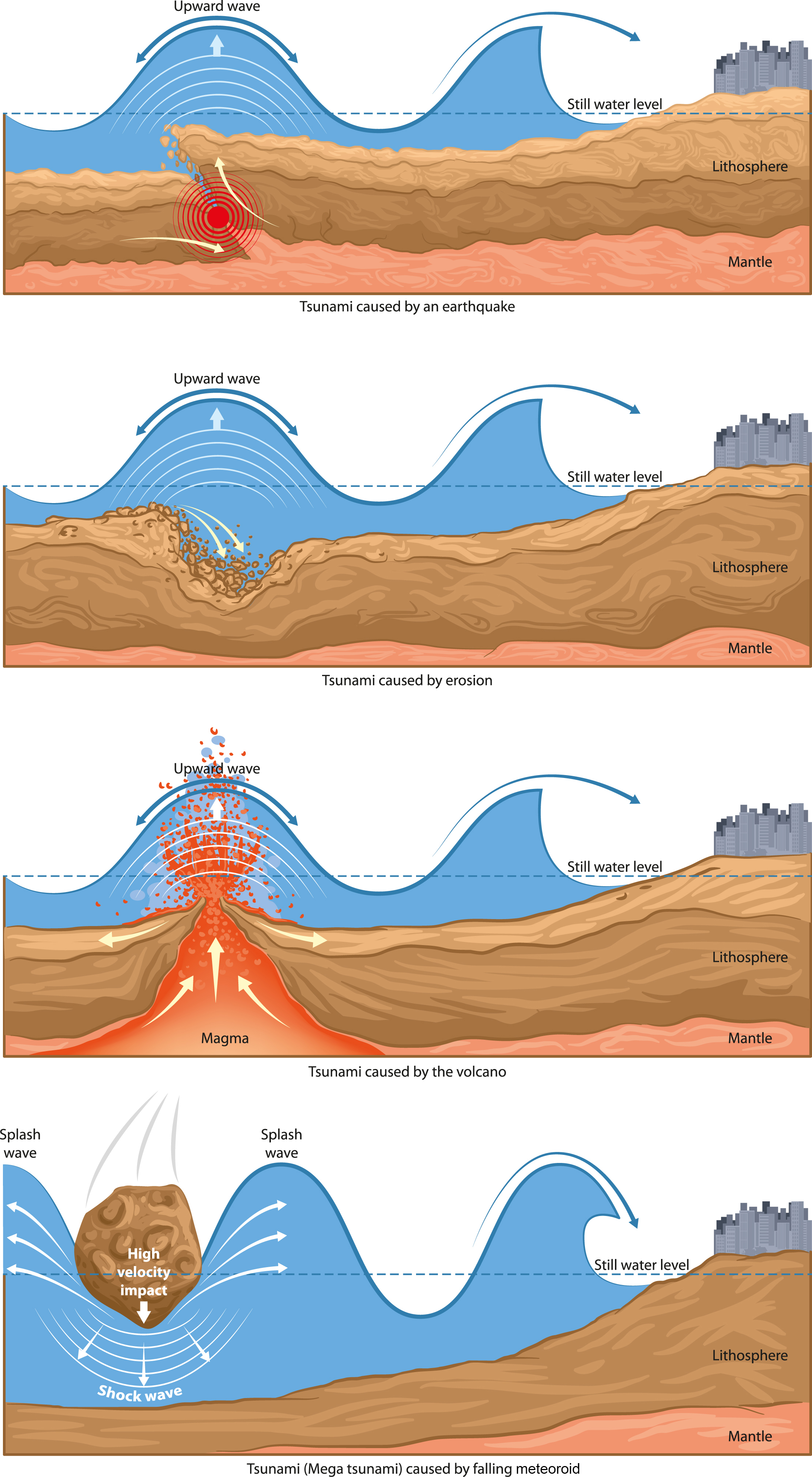
To understand what a tsunami is caused by from a technical perspective, we must look at the “triggers”—seismic shifts, volcanic activity, or underwater landslides—and how modern technology translates these physical movements into actionable digital insights.
The Hardware of Detection: Sensing the Subsea Shift
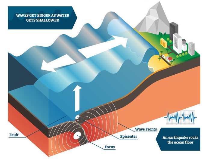
The primary cause of a tsunami is the sudden displacement of a large volume of water. Technically, this is most often triggered by “megathrust” earthquakes at subduction zones. To identify these causes before the waves reach the shore, a global network of IoT-enabled hardware has been deployed across the world’s oceans.
DART Systems and Real-Time Telemetry
The Deep-ocean Assessment and Reporting of Tsunamis (DART) system is perhaps the most critical piece of hardware in identifying what a tsunami is caused by in the moment. These systems consist of a bottom pressure recorder (BPR) anchored to the ocean floor and a surface buoy. When an earthquake occurs, the BPR detects the minute changes in water pressure that signify a passing tsunami wave. This data is then transmitted via acoustic telemetry to the surface buoy, which relays the information to satellites. This “Edge” processing of pressure data allows scientists to differentiate between a standard tidal swell and a displacement caused by seismic activity.
Seismic Sensor Networks and Global Connectivity
Before the water even moves, the tech world looks at the lithosphere. High-performance seismometers are distributed globally, connected via high-speed fiber-optic networks. These sensors measure the “p-waves” and “s-waves” of an earthquake. By utilizing triangulation algorithms, software can determine the epicenter and depth within seconds. This technical data is crucial because a tsunami is caused by vertical displacement; if the tech detects a horizontal “strike-slip” fault movement, the software can predict a lower probability of a wave, preventing unnecessary mass panic.
AI and Machine Learning: Modeling the “Why” and “Where”
While hardware detects the initial movement, software determines the outcome. One of the greatest challenges in understanding what a tsunami is caused by is the sheer number of variables involved: bathymetry (ocean floor topography), coastal geometry, and initial energy release.
Neural Networks for Wave Propagation
Traditional mathematical models used to take hours to calculate how a wave would travel. Modern AI models, trained on petabytes of historical seismic data, can now predict wave arrival times and heights in a fraction of a second. These neural networks look at the “cause”—for example, a 7.8 magnitude earthquake at a specific depth—and simulate millions of potential wave trajectories. By comparing real-time sensor data with these simulations, the software can pinpoint which coastal regions are at risk with unprecedented accuracy.
Solving the “Silent Tsunami” Problem
Not all tsunamis are caused by massive earthquakes. Some are caused by underwater landslides or “silent” volcanic collapses, such as the 2022 Hunga Tonga-Hunga Ha’apai eruption. These events are traditionally harder for standard seismic software to catch. However, new AI tools are being developed to monitor “Infrasound”—low-frequency sound waves that travel through the atmosphere and ocean. By analyzing these acoustic signatures, AI can identify causes of water displacement that traditional seismology might miss, providing a more comprehensive answer to the question of what a tsunami is caused by.
Satellite Geospatial Tech: The Eye in the Sky
To understand the full scale of what a tsunami is caused by, we must look beyond the ocean floor. Space technology has become an indispensable layer in the disaster-tech stack.
GNSS Reflectometry
Global Navigation Satellite Systems (GNSS), which power our GPS, are now being used for reflectometry. As satellite signals bounce off the ocean surface, the “noise” or distortion in the signal can be analyzed to measure sea-surface height. If a massive displacement occurs, these satellites can detect the change from orbit. This provides a secondary verification layer, ensuring that the data from ocean floor sensors is accurate and not a hardware malfunction.
Synthetic Aperture Radar (SAR) and Post-Event Analysis
After the “cause” has triggered the event, tech plays a role in identifying the extent of the damage. SAR satellites can see through clouds and darkness to map flooded areas in near real-time. By comparing pre- and post-event imagery, machine learning algorithms can calculate the exact volume of water that moved inland. This data is then fed back into the predictive models, helping the software learn more about how specific causes (like a landslide versus an earthquake) result in different types of land impact.
The Future of Disaster Tech: IoT and Public Warning Systems
The final frontier in addressing what a tsunami is caused by is the “last mile” of technology: getting information to the people. This involves a complex integration of telecommunications, cloud computing, and mobile software.
Smart Subsea Cables
A burgeoning trend in tech is the development of “Science Monitoring and Reliable Telecommunications” (SMART) cables. Since the world is already crisscrossed with thousands of miles of fiber-optic cables for the internet, tech companies are beginning to integrate sensors directly into the cable repeaters. This would create a dense, persistent web of sensors capable of detecting the seismic causes of tsunamis at a much lower cost and higher density than standalone buoys.
Multi-Channel Cloud Alerting
Once the tech identifies that a tsunami is caused by a specific seismic event, the cloud takes over. Integrated Public Alert and Warning Systems (IPAWS) use high-concurrency cloud architecture to push millions of notifications to smartphones, digital billboards, and radio stations simultaneously. This requires low-latency infrastructure to ensure that the “data” (the warning) travels faster than the “physical wave.”
Conclusion: A Data-Driven Shield
Understanding what a tsunami is caused by is no longer just a matter of observing the ocean; it is a matter of mastering data. From the moment a tectonic plate slips to the second a wave hits the shore, a massive “Tech Tsunami” of data is processed across the globe.
Through the combination of subsea IoT sensors, AI-driven predictive modeling, and satellite geospatial analysis, the tech industry has transformed one of nature’s most unpredictable forces into a measurable, manageable risk. As we continue to refine these tools—integrating AI further into our seismic networks and leveraging existing global infrastructure like fiber-optic cables—our ability to detect the causes and predict the effects of tsunamis will only grow. In this digital age, the best defense against a surge of water is a surge of information.
aViewFromTheCave is a participant in the Amazon Services LLC Associates Program, an affiliate advertising program designed to provide a means for sites to earn advertising fees by advertising and linking to Amazon.com. Amazon, the Amazon logo, AmazonSupply, and the AmazonSupply logo are trademarks of Amazon.com, Inc. or its affiliates. As an Amazon Associate we earn affiliate commissions from qualifying purchases.