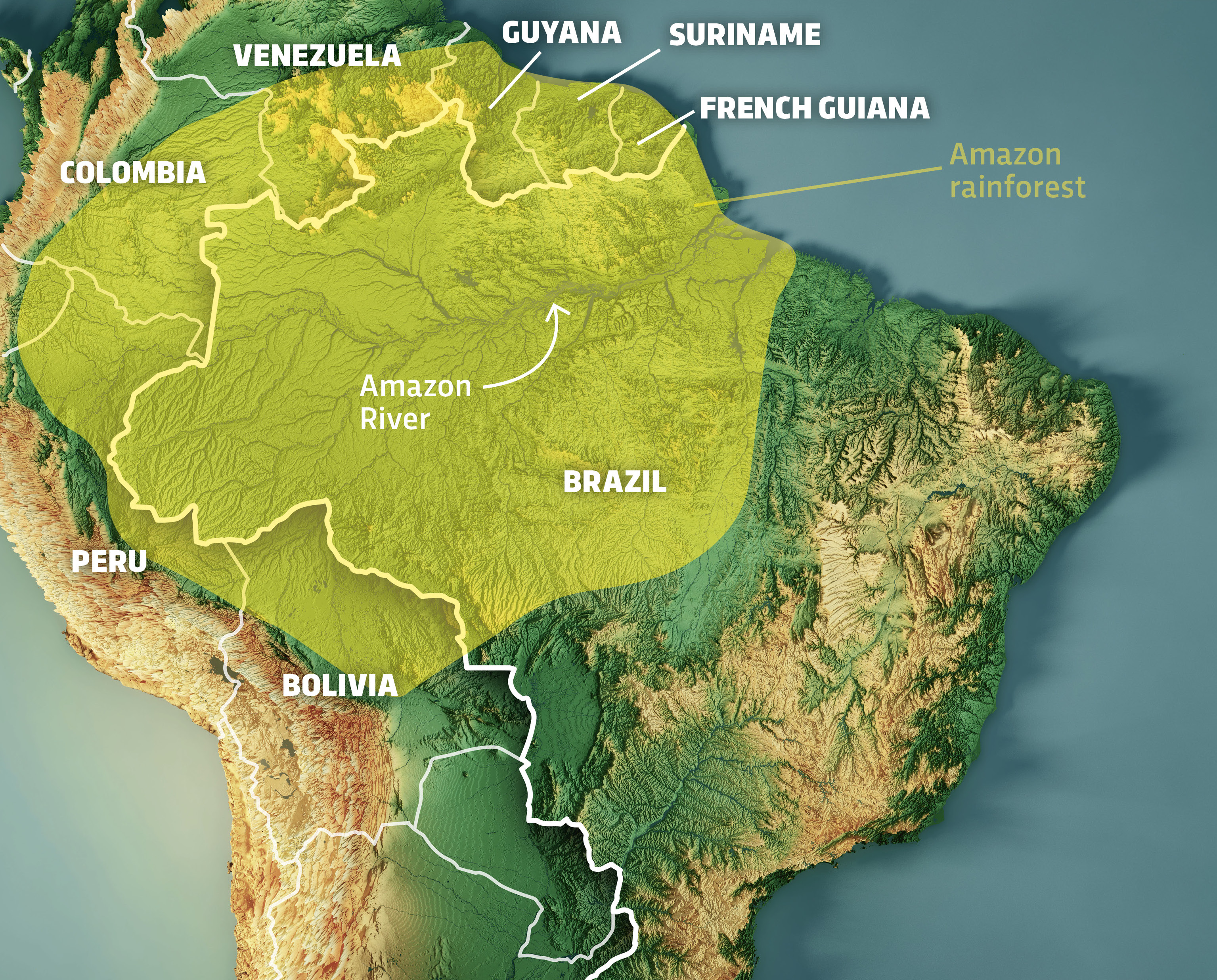
The Brazilian Amazon is often described through superlatives: the “lungs of the planet,” the most biodiverse region on Earth, and a geographical titan spanning over 5.5 million square kilometers. However, for the modern technologist, researcher, or environmental engineer, the question of “how big” the rainforest is cannot be answered by a simple static number on a map. In the digital age, the size of the Brazilian rainforest is a dynamic data set, constantly being recalculated, mapped, and analyzed through an sophisticated stack of remote sensing, artificial intelligence, and aerospace hardware.
As we move deeper into the 21st century, the technologies used to monitor this vast biome have evolved from rudimentary aerial photography to a complex ecosystem of real-time digital surveillance. Understanding the scale of the Amazon today requires a deep dive into the software and hardware that allow us to visualize a territory so vast it defies traditional measurement.
The Digital Eye: Satellite Remote Sensing and Earth Observation
To understand the physical footprint of the Brazilian rainforest, we must look upward. The primary method for measuring the “bigness” of the Amazon is through a constellation of Earth Observation (EO) satellites. These are not merely cameras in space; they are sophisticated multispectral sensors that capture data across various wavelengths, providing a granular view of the forest floor that the human eye could never perceive.
High-Resolution Optical Imaging and the Landsat Legacy
For decades, the benchmark for measuring the Amazon has been the Landsat program, a joint NASA/USGS initiative. Landsat satellites provide what tech analysts call “medium resolution” data, which is essential for longitudinal studies. By processing decades of archival data, software systems can track the expansion and contraction of the forest with surgical precision.
In recent years, private tech firms like Planet Labs have revolutionized this space by deploying “CubeSats”—miniature satellites that provide daily revisits of the entire Amazon basin. Unlike the 16-day cycle of older systems, this high-frequency data stream allows for a “live” measurement of the rainforest. The sheer volume of data produced—terabytes per day—requires massive cloud computing infrastructure, typically hosted on platforms like Google Earth Engine, to process and render the “size” of the forest in near real-time.
SAR Technology: Piercing Through the Canopy and Clouds
One of the greatest technical hurdles in measuring the Brazilian rainforest is its climate. The Amazon is frequently shrouded in thick cloud cover, making optical sensors useless for large portions of the year. To solve this, technologists employ Synthetic Aperture Radar (SAR).
SAR sensors, such as those on the European Space Agency’s Sentinel-1 satellites, emit microwave pulses that penetrate clouds, smoke, and even the upper layers of the forest canopy. By measuring the “backscatter” of these pulses, algorithms can map the physical structure of the terrain below. This tech is crucial for identifying “how big” the forest remains during the rainy season, ensuring there are no blind spots in our digital inventory of the biome.
Artificial Intelligence and Machine Learning in Forest Monitoring
If satellites are the eyes, then Artificial Intelligence (AI) is the brain that interprets the data. Measuring a forest that covers nearly 60% of Brazil’s landmass is an impossible task for human analysts alone. The scale of the data necessitates the use of Machine Learning (ML) to automate the identification of land-use changes.
Automated Change Detection and Neural Networks
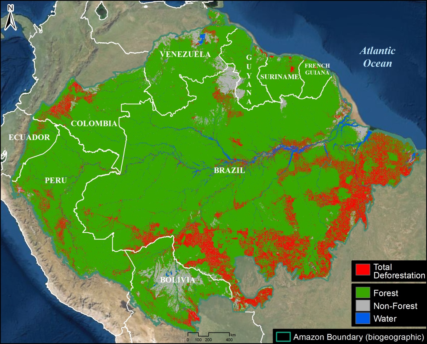
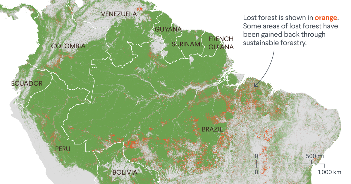
The Brazilian National Institute for Space Research (INPE) utilizes a system known as DETER (Real-Time Deforestation Detection). This system leverages Convolutional Neural Networks (CNNs) to automatically identify patterns of forest loss. These AI models are trained on millions of labeled images to distinguish between natural occurrences—such as a river changing course or a tree falling from old age—and anthropogenic activities like illegal logging or land clearing for cattle ranching.
By automating this process, the “size” of the rainforest is no longer an estimate updated once a year; it is a fluid metric updated every few days. AI tools can now flag suspicious activity in areas as small as a quarter of a hectare, allowing for rapid response and more accurate statistical modeling of the forest’s total biomass.
Predictive Analytics for Ecosystem Health
Beyond just measuring area, AI is being used to measure “quality.” Using predictive analytics, researchers can determine the degradation levels of the forest—areas that are technically still “green” on a map but have lost their ecological integrity. By analyzing pixel-level changes in leaf moisture and canopy density, AI tools can predict which areas are at the highest risk of transitioning from forest to savannah. This shifts the definition of “how big” the rainforest is from a 2D surface area calculation to a 3D assessment of ecosystem health and resilience.
LiDAR and the Vertical Dimension of the Rainforest
When we ask how big the Brazilian rainforest is, we are often only thinking about its length and width. However, to a tech-driven environmentalist, “bigness” also includes volume. This is where Light Detection and Ranging (LiDAR) technology comes into play.
Laser Scanning for Biomass Estimation
LiDAR involves firing millions of laser pulses from an aircraft or drone toward the forest floor. By measuring the time it takes for each pulse to bounce back, sensors create a high-resolution 3D point cloud of the forest structure. This technology allows scientists to “see” under the canopy, measuring the height of individual trees and the density of the undergrowth.
This is critical for calculating carbon sequestration. A tall, old-growth forest and a young, regrowing forest might look the same on a low-resolution satellite map, but LiDAR reveals the massive difference in their “size” in terms of stored carbon and biological complexity. High-end LiDAR sensors are now being integrated with AI to estimate the total biomass of the Brazilian Amazon, providing a far more sophisticated answer to the question of its scale than mere acreage.
Creating Digital Twins of the Amazon
The ultimate goal of using LiDAR and high-res imagery is the creation of a “Digital Twin” of the Brazilian rainforest. In the world of tech and software engineering, a Digital Twin is a virtual representation that serves as the real-time digital counterpart of a physical object or process. By integrating LiDAR data with ground-based IoT sensors, technologists are building a virtual Amazon. This allows for complex simulations—such as how a 2-degree Celsius rise in temperature would impact the forest’s size—enabling a proactive rather than reactive approach to conservation.
Decentralized Tech and Real-Time Security
The final piece of the puzzle in measuring and protecting the scale of the Amazon is the deployment of “On-the-Edge” technology. This involves hardware that lives within the forest itself, providing a layer of digital security that satellites cannot achieve.
IoT Sensors and Acoustic Monitoring
To truly understand the “bigness” of the forest, we must also listen to it. “Top-down” measurement via satellite is often supplemented by “bottom-up” data from Internet of Things (IoT) devices. One of the most innovative tech trends in the Amazon is the use of acoustic sensors. These devices, often recycled smartphones powered by solar panels, are hidden in the canopy.
Equipped with AI-driven audio processing, these sensors can detect the specific frequency of a chainsaw or a logging truck from miles away. When a sound is identified, the device sends a real-time alert via satellite link to local authorities. This “Smart Forest” approach ensures that the size of the rainforest is protected by a digital perimeter, turning the forest itself into an interconnected, self-reporting network.
Blockchain for Verifiable Conservation Data
In the realm of digital security and data integrity, blockchain technology is beginning to play a role in how we record the size and health of the Brazilian rainforest. One of the challenges in environmental tech is the “trust gap”—ensuring that data regarding forest preservation is accurate and untampered with.
By recording satellite-verified forest metrics on a decentralized ledger, NGOs and government agencies can create a transparent record of the forest’s status. This is particularly relevant for the “Money” side of tech—specifically carbon credits—but from a purely technological standpoint, blockchain provides the immutable architecture needed to store the massive amounts of data required to track the Amazon’s scale over decades.
The Future of the Rainforest is Digital
The Brazilian rainforest is a vast, organic entity, but our understanding of it is increasingly digital. We no longer rely on physical surveys or hand-drawn maps to understand its scale. Instead, we use a sophisticated tech stack comprising orbital sensors, neural networks, laser-based 3D modeling, and IoT networks.
The question “how big is the Brazilian rainforest” is now a query that can be answered with petabytes of data, providing a resolution of centimeters rather than kilometers. As technology continues to evolve, our ability to monitor, measure, and ultimately protect this critical global asset will only become more precise. In the intersection of nature and technology, the Amazon is no longer a mystery; it is the most closely monitored and digitally rendered ecosystem on our planet.
aViewFromTheCave is a participant in the Amazon Services LLC Associates Program, an affiliate advertising program designed to provide a means for sites to earn advertising fees by advertising and linking to Amazon.com. Amazon, the Amazon logo, AmazonSupply, and the AmazonSupply logo are trademarks of Amazon.com, Inc. or its affiliates. As an Amazon Associate we earn affiliate commissions from qualifying purchases.