
The term “snow squall” often conjures images of sudden, blinding whiteouts and treacherous driving conditions. While a relatively localized and short-lived weather event, its impact can be profound, leading to multi-car pile-ups, significant travel disruptions, and even fatalities. In an era increasingly reliant on interconnected systems and real-time information, understanding these meteorological phenomena isn’t just a matter of curiosity—it’s a critical component of public safety and economic resilience. But beyond the immediate danger, what exactly defines a snow squall, and more importantly, how are cutting-edge technologies transforming our ability to predict, respond to, and ultimately mitigate the risks associated with these sudden winter onslaughts? From advanced AI forecasting models to smart infrastructure and digital security protocols, technology is at the forefront of our defense against nature’s most abrupt winter challenges. This exploration delves into the scientific underpinnings of snow squalls and showcases how the tech industry is innovating to make our world safer and more prepared.

Understanding the Meteorological Phenomenon: A Tech-Aided Perspective
Before we delve into the technological solutions, it’s essential to establish a clear understanding of what a snow squall entails. Unlike a prolonged snowstorm, a squall is characterized by its sudden onset, intense snowfall, and often powerful winds, leading to dramatic reductions in visibility over a short period. This rapid transition from clear skies to blizzard-like conditions is what makes them so dangerous, catching drivers and communities unprepared. Technology, however, is not merely a reactive tool; it’s increasingly integrated into our fundamental understanding and real-time observation of these events, providing data that refines our definitions and deepens our scientific comprehension.
Defining the Sudden Winter Threat
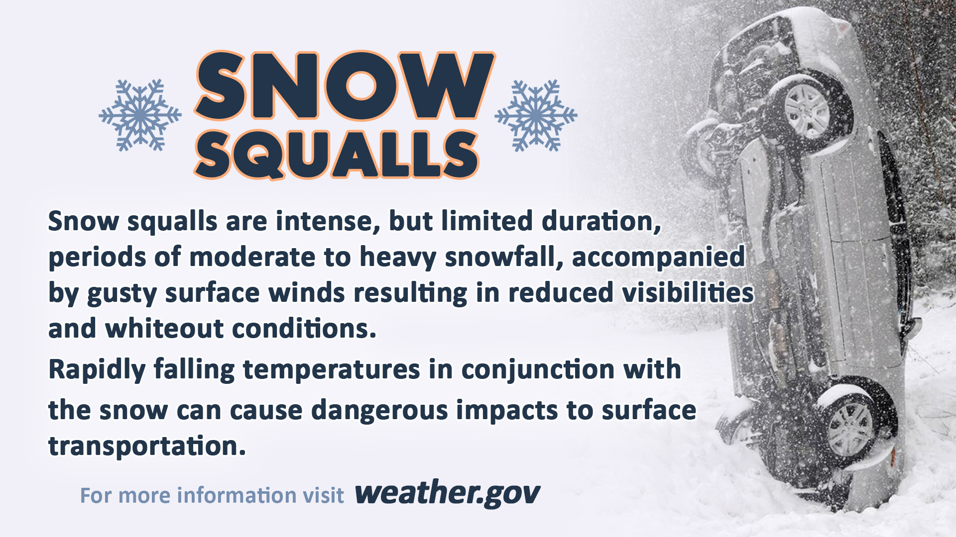
A snow squall is officially defined as an intense, short-lived burst of heavy snowfall accompanied by strong, gusty winds, leading to whiteout conditions and potentially rapidly accumulating snow. These events typically last for minutes to an hour and often occur with cold fronts, lake-effect snow bands, or even without any significant larger weather system nearby. The National Weather Service in the U.S., for instance, issues specific “Snow Squall Warnings” to alert the public to these perilous conditions, distinct from general winter weather advisories or blizzard warnings due to their unique characteristics of suddenness and intensity. The precision in this definition is not arbitrary; it’s honed by decades of meteorological observation, increasingly augmented by digital sensor networks and sophisticated data analytics that allow for finer distinctions between various types of winter precipitation. These digital tools gather high-resolution atmospheric data, helping meteorologists differentiate between a sustained snow event and the sharp, localized impact of a squall, thereby enabling more targeted and effective public alerts.
The Science of Formation: Data-Driven Insights
The formation of snow squalls is a complex interplay of atmospheric conditions, often involving cold air masses passing over relatively warmer bodies of water (like the Great Lakes, leading to lake-effect squalls) or the rapid descent of cold, dry air behind a front that interacts with moist air at the surface. This interaction creates instability, leading to narrow, intense bands of precipitation. Modern meteorology leverages an extensive array of technological tools to model and understand these processes. High-resolution numerical weather prediction (NWP) models, powered by supercomputers, ingest vast amounts of data from satellites, radar, weather balloons, and ground-based sensors. These models simulate atmospheric dynamics down to incredibly fine scales, allowing scientists to pinpoint the precise conditions conducive to squall development. AI and machine learning algorithms are now enhancing these models, identifying subtle patterns in historical data that precede squalls, thereby improving the accuracy of both short-term forecasts and our fundamental scientific understanding of these rapidly evolving phenomena. The ability to process petabytes of atmospheric data in near real-time is a testament to how computational power and sophisticated software are revolutionizing our comprehension of even the most fleeting weather events.
The Digital Frontier of Snow Squall Prediction
The ultimate goal in understanding snow squalls is to predict them with enough lead time to ensure public safety. Historically, the sudden nature of squalls made them notoriously difficult to forecast. However, the rapid evolution of digital technologies, from advanced sensor networks to sophisticated AI, is ushering in a new era of predictive capabilities, turning once-unforeseeable events into manageable threats. These advancements are not merely incremental; they represent a paradigm shift in how we anticipate and prepare for severe weather, blurring the lines between traditional meteorology and cutting-edge tech development.
Advanced Radar and Satellite Systems
The cornerstone of modern weather prediction lies in the sophisticated network of radar and satellite systems. Doppler radar, in particular, is crucial for detecting snow squalls. Unlike older radar, Doppler systems can measure the velocity of precipitation particles, allowing meteorologists to identify areas of rapid air movement and intense precipitation associated with squalls. Dual-polarization radar further enhances this capability by distinguishing between rain, snow, and hail, providing more precise information on the type and intensity of precipitation. Geostationary and polar-orbiting satellites, equipped with advanced infrared and visible light sensors, offer a broader view, tracking cloud formation, temperature gradients, and moisture content across vast regions. These data streams, processed by powerful software platforms, provide a continuous, high-resolution picture of the atmosphere, allowing forecasters to monitor the development and movement of squall lines in near real-time. The sheer volume and granularity of data generated by these gadgets are staggering, requiring robust digital infrastructure and advanced algorithms to interpret and translate into actionable forecasts.
AI and Machine Learning in Forecasting
The massive datasets generated by radar, satellites, and other sensors present an ideal scenario for the application of artificial intelligence and machine learning. AI algorithms are proving invaluable in identifying complex, non-linear patterns in atmospheric data that human forecasters might miss. Neural networks can be trained on decades of weather observations, learning to recognize the atmospheric precursors to snow squalls with increasing accuracy. For example, machine learning models can analyze minute changes in temperature, humidity, wind shear, and pressure to predict the likelihood and location of squall development hours in advance. Predictive analytics, driven by AI, can also refine the resolution of forecasts, moving beyond regional predictions to hyper-local advisories. This means an AI-powered system could potentially predict a squall affecting a specific highway segment, rather than just an entire county. Furthermore, AI is being used to improve the efficiency and accuracy of existing numerical weather models by optimizing their parameters and correcting for biases, ultimately leading to more reliable and timely snow squall warnings, transforming raw data into life-saving intelligence.
Hyperlocal Weather Apps and Alerts
The ultimate objective of advanced prediction technology is to deliver timely and accurate information directly to the public. This is where hyperlocal weather apps and digital alert systems come into play. Mobile applications, powered by the very same advanced forecasting models and AI insights, provide users with real-time, location-specific weather updates. Many modern weather apps now incorporate push notifications specifically for severe weather events like snow squalls, alerting users moments after a warning is issued. These apps leverage GPS data from smartphones to provide highly localized information, ensuring that individuals receive alerts relevant to their immediate surroundings, whether they are at home, commuting, or traveling. Furthermore, platforms like the Wireless Emergency Alerts (WEA) system, integrated into mobile networks, allow government agencies to send geographically targeted emergency messages directly to mobile phones in affected areas. This direct-to-consumer digital security feature ensures that critical information bypasses traditional media and reaches individuals instantly, serving as a vital last line of defense against the sudden dangers posed by a snow squall. The design and usability of these apps are critical, representing the interface between complex meteorological data and public safety, making abstract data actionable for the everyday user.

Tech Solutions for Navigating Squall Conditions
Even with the most advanced prediction, snow squalls can develop or intensify rapidly, leaving little time to react. Therefore, technology also plays a crucial role in enabling safer navigation and ensuring operational continuity during squall conditions. From autonomous vehicle integration to robust communication systems, tech tools are engineered to enhance safety and resilience when visibility plummets and conditions become treacherous. These solutions integrate hardware and software, creating a comprehensive approach to mitigating immediate risks.
Smart Infrastructure and Connected Vehicles
The concept of smart cities and connected infrastructure is particularly relevant during snow squalls. Sensors embedded in roads can monitor surface temperatures and detect precipitation, alerting transportation authorities to hazardous conditions and enabling prompt salting or plowing. Variable message signs, digitally controlled, can update in real-time to warn drivers of approaching squalls or recommended detours. More futuristically, connected vehicles (V2V and V2I communication) hold immense potential. Cars could share real-time data on road conditions, traction loss, and visibility with other vehicles and infrastructure. Autonomous and semi-autonomous vehicles, equipped with advanced lidar, radar, and thermal cameras, are being developed to navigate low-visibility conditions far more effectively than human drivers. While fully autonomous navigation in a whiteout is still a significant challenge, these gadgets and their underlying software are rapidly improving, promising a future where vehicles can autonomously slow down, activate emergency lights, and even communicate potential hazards to other road users, dramatically reducing the risk of multi-car collisions during a squall.
Emergency Communication and Digital Security During Outages
Snow squalls, especially when accompanied by strong winds, can lead to power outages and disruption of communication infrastructure. Maintaining emergency communication channels and ensuring digital security during these times is paramount. Satellite phones and mesh networking gadgets can provide redundant communication options when cellular towers are down. Battery backup systems and generators for critical infrastructure, often monitored and managed by smart grid software, ensure that essential services remain operational. From a digital security standpoint, securing these alternative communication channels and data flows becomes critical. Encrypted messaging apps and secure network protocols are essential to prevent malicious actors from exploiting vulnerabilities during a crisis. Tutorials for users on how to prepare their devices for power outages (e.g., fully charging phones, downloading offline maps) also contribute to individual preparedness. Furthermore, digital platforms for community alerts and resource coordination need to be resilient against cyber threats, ensuring that vital information about shelters, road closures, or emergency services remains accessible and uncompromised, even if primary systems are under physical or digital stress.
Gadgets and Gear for Enhanced Safety
Beyond large-scale infrastructure, personal gadgets and specialized gear are also crucial for individual safety during and after a snow squall. High-quality headlamps and LED lanterns with long battery life are essential when power is out. Portable weather radios, often hand-cranked or solar-powered, ensure access to vital information even when cell service is down. For outdoor enthusiasts or those living in remote areas, GPS trackers with satellite communication capabilities (like those offering SOS features) can be life-saving. Even simpler, yet technologically advanced, items like chemical hand warmers or heated apparel (powered by portable battery packs) can provide crucial warmth. For vehicle safety, sophisticated dash cams can capture crucial evidence in the event of an accident during low visibility. Furthermore, vehicle telematics systems, which monitor a car’s performance and location, can automatically alert emergency services in the event of a crash. The integration of advanced sensors into wearables (like smartwatches that monitor body temperature or detect falls) also adds a layer of personal safety, particularly for vulnerable populations who might be more susceptible to the effects of sudden cold and isolation. These gadgets, often linked by software, represent the tangible application of tech trends for immediate personal protection.
Building Resilience: Long-Term Technological Strategies
While predicting and navigating immediate squall conditions are critical, the long-term perspective involves building systemic resilience. Technology offers powerful tools not just for reactive measures but for proactive planning, climate adaptation, and designing more robust systems that can withstand future severe weather events. This holistic approach integrates big data, advanced analytics, and strategic infrastructure development to create communities better equipped to handle the increasing frequency and intensity of climate-related disruptions.
Climate Modeling and Predictive Analytics
The global climate is changing, leading to shifts in weather patterns and potentially altering the frequency or intensity of phenomena like snow squalls. Advanced climate modeling software, running on high-performance computing clusters, allows scientists to simulate future climate scenarios, helping policymakers and infrastructure planners anticipate long-term trends. These models, fed by historical weather data and sophisticated algorithms, are crucial for understanding how regional climates might evolve. Predictive analytics, going beyond immediate forecasts, can identify areas at higher risk for squall development in future decades, informing decisions on urban planning, infrastructure investments, and emergency resource allocation. For example, if climate models predict shifts in lake-effect snow belts, communities can proactively strengthen their power grids, improve road maintenance capabilities, or develop new emergency response protocols. This strategic use of data and AI tools transforms passive observation into active foresight, laying the groundwork for adaptive strategies against a dynamic climate.
Tech-Driven Community Preparedness
Effective community preparedness extends beyond individual warnings; it involves integrated systems and public engagement fostered by technology. Online platforms and apps can serve as centralized hubs for emergency information, including evacuation routes, shelter locations, and real-time status updates from utility companies. Digital security measures are paramount for these platforms, ensuring that critical information remains accurate and accessible during a crisis. Social media monitoring tools, often powered by AI, can track public discourse during and after an event, helping emergency managers identify areas of need or misinformation. Tutorials and educational apps can provide accessible information on how to prepare emergency kits, secure homes, and safely respond to squalls. Furthermore, the use of Geographic Information Systems (GIS) software allows planners to visualize and analyze community vulnerabilities, such as identifying critical infrastructure at risk or pinpointing areas with high concentrations of vulnerable populations, facilitating targeted resource deployment and planning exercises. This holistic approach empowers citizens and local authorities with the knowledge and tools to act decisively.
Innovation in Disaster Response
When snow squalls lead to larger-scale emergencies, technological innovation is vital for efficient disaster response and recovery. Drones equipped with thermal cameras and LiDAR can quickly assess damage to infrastructure in inaccessible areas, locate stranded individuals, or deliver small emergency supplies. Robotics can be deployed for hazardous tasks, such as clearing debris or inspecting damaged structures, reducing risk to human responders. AI-powered analytics can process satellite imagery and social media data post-event to rapidly assess the extent of damage, prioritize recovery efforts, and allocate resources effectively. Cloud-based platforms facilitate seamless coordination between various emergency services, government agencies, and non-profit organizations, ensuring that information is shared in real-time and efforts are not duplicated. Digital security protocols within these collaborative platforms are crucial to protect sensitive information and maintain operational integrity. Furthermore, advancements in portable power solutions and ruggedized communication gadgets ensure that first responders can maintain operations even in severely impacted environments, bridging the gap between immediate crisis and long-term recovery, and demonstrating the full spectrum of tech’s role from prevention to rebuilding.
aViewFromTheCave is a participant in the Amazon Services LLC Associates Program, an affiliate advertising program designed to provide a means for sites to earn advertising fees by advertising and linking to Amazon.com. Amazon, the Amazon logo, AmazonSupply, and the AmazonSupply logo are trademarks of Amazon.com, Inc. or its affiliates. As an Amazon Associate we earn affiliate commissions from qualifying purchases.