
The seemingly simple question, “What is the radius of Earth in meters?”, unravels a profound narrative of human ingenuity, scientific discovery, and the relentless march of technological advancement. While a definitive, single number for Earth’s radius might seem straightforward, the reality is far more complex, requiring sophisticated technology to measure, model, and apply this fundamental geodetic parameter. In an era dominated by global navigation systems, satellite communications, and intricate climate models, understanding Earth’s dimensions with precision, in meters, is not merely an academic exercise but a critical technological imperative. This article delves into how technology has transformed our understanding and measurement of Earth’s radius, why this precision is crucial in various digital age applications, and the ongoing technological quest to refine these measurements further.

The Quest for Precision: Measuring Earth’s Radius Through Technology
For millennia, humanity has pondered the size and shape of our planet. Early civilizations made rudimentary estimates, often assuming a flat Earth. The concept of a spherical Earth emerged later, with ancient Greek scholars like Eratosthenes making remarkably accurate estimations using observational astronomy and simple geometry. However, achieving truly precise measurements in meters, which account for Earth’s true irregular shape, demanded a technological leap that only modern advancements could provide.
Early Geodesy and the Dawn of Scientific Measurement
The foundational efforts in geodesy, the scientific discipline of measuring and understanding Earth’s geometric shape, orientation in space, and gravity field, began in earnest centuries ago. Triangulation surveys, employing sophisticated (for their time) telescopes, theodolites, and meticulously crafted measuring chains, allowed cartographers and scientists to map vast territories and establish baselines. These ground-based measurements, while incredibly labor-intensive and susceptible to local topographical biases, provided the first scientific estimates of Earth’s circumference and, consequently, its radius. French expeditions in the 17th and 18th centuries, attempting to measure meridian arcs at different latitudes, famously provided evidence that Earth was not a perfect sphere but an oblate spheroid – bulging at the equator and flattened at the poles. The results of these expeditions, though expressed in ancient units, laid the groundwork for the metric system’s development and the subsequent demand for measurements in meters. The precision achieved was groundbreaking for its time, but still lacked the global consistency and accuracy required for modern technological applications.
Satellite Geodesy and GPS: Revolutionizing Accuracy
The mid-20th century heralded the space age, fundamentally transforming our ability to measure Earth. The launch of artificial satellites provided an unprecedented platform for global geodetic measurements. Satellite Geodesy involves tracking the orbits of satellites and analyzing their trajectories, which are influenced by Earth’s gravitational field and shape. By observing satellites from multiple ground stations, scientists can accurately determine the coordinates of these stations and, by extension, the precise dimensions of Earth.
The Global Positioning System (GPS), developed by the U.S. military and made available for civilian use, is perhaps the most ubiquitous example of satellite technology providing Earth radius data. GPS satellites orbit at a known altitude and transmit signals containing precise timing and orbital information. Receivers on Earth triangulate their position by measuring the time delay of these signals from multiple satellites. The underlying mathematical models that power GPS rely heavily on an accurate geodetic model of Earth, including its radius in meters, to provide centimeter-level positional accuracy. Without a precise understanding of Earth’s dimensions, derived from satellite data, GPS would be functionally useless for navigation, mapping, and countless other applications that demand real-time, high-precision location data globally.
VLBI and Laser Ranging: Unveiling Dynamic Earth
Beyond GPS, other advanced space-geodesy techniques contribute to an even more refined understanding of Earth’s dynamic radius. Very Long Baseline Interferometry (VLBI) uses networks of radio telescopes to observe distant quasars, effectively creating a “celestial ruler” to measure baselines between points on Earth with astonishing accuracy. By precisely measuring the arrival times of radio waves from these cosmic sources, VLBI can detect changes in the distances between continents and thus monitor plate tectonics and Earth’s rotational variations, which subtly affect its effective radius.
Similarly, Satellite Laser Ranging (SLR) and Lunar Laser Ranging (LLR) involve bouncing laser pulses off satellites (or the moon) and measuring the round-trip travel time with extreme precision. These techniques provide crucial data for determining the center of mass of the Earth, monitoring sea level rise, and tracking crustal deformations – all of which contribute to understanding the dynamic, rather than static, nature of Earth’s radius and its measurement in meters. These technologies allow scientists to observe changes on the scale of millimeters per year, providing insights into the planet’s evolving dimensions due to geological processes and climate change.
Why a Precise Radius Matters in the Digital Age
The precise knowledge of Earth’s radius, expressed in meters, is not merely an interesting scientific fact. It is a fundamental input for an enormous array of technologies and applications that define our modern world. From seamless navigation to global communication and critical environmental monitoring, the accuracy of this measurement underpins countless systems.
GPS and Global Navigation Systems
As touched upon earlier, GPS and its counterparts (GLONASS, Galileo, BeiDou) are entirely dependent on a precise geodetic model of Earth, including its average radius and its specific shape in meters. Every time a smartphone calculates a route, a delivery drone navigates to its destination, or an autonomous vehicle stays within its lane, it is leveraging complex algorithms that factor in Earth’s dimensions. Errors in the assumed radius would lead to significant positional inaccuracies, rendering these systems unreliable or dangerous. For example, a mere meter of error in radius calculation can translate to substantial positional drift over long distances or critical deviations in highly precise applications.
Satellite Communication and Orbit Mechanics
The vast network of communication satellites orbiting Earth facilitates everything from international phone calls and internet access to broadcasting and weather forecasting. The design, launch, and maintenance of these satellite orbits require an extremely accurate understanding of Earth’s gravitational field and its dimensions. Calculating the precise trajectory to place a satellite in a geostationary orbit (around 35,786 kilometers above the equator) or a low Earth orbit (LEO) involves intricate celestial mechanics that are sensitive to the Earth’s exact radius and its gravitational anomalies. Any miscalculation in meters could result in a failed launch, an incorrect orbital path, or premature satellite re-entry, representing multi-million dollar failures and critical disruptions to global services.
Geographic Information Systems (GIS) and Mapping
Geographic Information Systems (GIS) are powerful tools used for creating, managing, analyzing, and mapping all types of data. From urban planning and resource management to disaster response and scientific research, GIS relies on a framework of georeferenced data. The accuracy of these maps and analyses is directly tied to the underlying geodetic models, which incorporate Earth’s radius. For instance, when calculating areas of land, distances between points, or the elevation profiles for construction projects, precise meters are paramount. Without accurate radius data, maps would be distorted, measurements unreliable, and spatial analyses flawed, leading to poor decision-making and inefficient resource allocation.
Space Exploration and Mission Planning
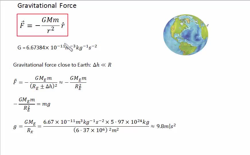
Venturing beyond Earth requires an even more meticulous understanding of our home planet’s dimensions. Launching rockets, planning trajectories for lunar missions, or sending probes to other planets all begin with precise calculations relative to Earth. The velocity required to escape Earth’s gravity well, the orbital mechanics for rendezvous in space, and the complex maneuvers involved in interplanetary travel are all based on Earth’s gravitational parameters, which are intrinsically linked to its mass and radius. NASA, ESA, and other space agencies utilize the most advanced geodetic models, expressing Earth’s radius in meters with extraordinary precision, to ensure mission success, from escaping our planet’s pull to guiding spacecraft safely back through its atmosphere.
The Earth’s Irregularity: Beyond a Simple Sphere
One of the most profound insights gained through advanced technology is the realization that Earth is not a perfect sphere, nor even a perfectly smooth oblate spheroid. Its surface and gravitational field are dynamic and irregular, necessitating sophisticated models to capture its true dimensions in meters.
Oblate Spheroid Model: The Geoid and Ellipsoid
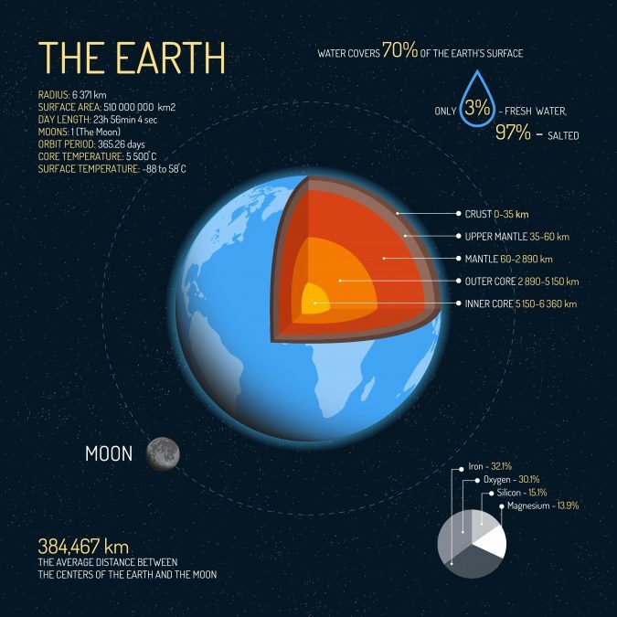
While often approximated as an average radius of about 6,371,000 meters, Earth is more accurately described by an oblate spheroid – a sphere flattened at the poles and bulging at the equator. This is due to its rotation, which creates a centrifugal force greatest at the equator. The equatorial radius is approximately 6,378,137 meters, while the polar radius is about 6,356,752 meters. This difference of roughly 21 kilometers is significant for precise applications.
However, even the oblate spheroid is an idealization. The true physical surface of Earth, accounting for mountains, valleys, and ocean trenches, is called the topographic surface. For many geodetic purposes, scientists use the concept of the “geoid,” which is the equipotential surface of Earth’s gravity field that best approximates mean sea level globally. The geoid is irregular and lumpy due to variations in mass distribution within the Earth. To simplify calculations for mapping and navigation, a mathematically defined “reference ellipsoid” is used, which is a smooth oblate spheroid that best fits the geoid globally or regionally. Modern technology allows us to define and use these complex models, switching between the physical surface, the geoid, and the reference ellipsoid, all expressed in precise meters, depending on the application’s needs.
Gravitational Fields and Dynamic Topography
Technological tools, particularly gravimeters and satellite gravity missions like GRACE and GOCE, have allowed us to map Earth’s gravitational field with unprecedented detail. Variations in gravity correspond to variations in mass distribution and thus subtly influence the shape of the geoid and the effective “radius” at different points. These variations are not static; geological processes like tectonic plate movements, volcanic activity, and even the redistribution of water masses (e.g., melting glaciers, seasonal river flows) constantly alter Earth’s mass distribution and, consequently, its gravitational field and shape. Monitoring these dynamic changes requires continuous data collection and analysis using advanced satellite technology.
Advanced Computational Models and Data Fusion
The sheer volume of data generated by satellite geodesy, VLBI, SLR, and ground-based measurements is immense. Modern computational power, sophisticated algorithms, and data fusion techniques are essential to process this information and synthesize it into coherent, accurate geodetic models. These models, often represented by hundreds or thousands of parameters, provide the most precise representation of Earth’s radius, its irregularities, and its changes over time. Machine learning and AI are increasingly being deployed to sift through this data, identify subtle patterns, and improve the predictive capabilities of these models, ensuring that the radius in meters used for critical applications is as accurate and up-to-date as possible.
Future Frontiers: AI, Big Data, and Earth’s Evolving Dimensions
The journey to precisely define Earth’s radius in meters is far from over. As our planet continues to undergo environmental and geological changes, and as our technological needs become ever more demanding, the quest for precision continues to evolve, driven by cutting-edge innovations.
Machine Learning in Geodetic Data Analysis
Artificial intelligence and machine learning are poised to revolutionize geodesy further. Analyzing the vast datasets from various satellites and ground sensors, ML algorithms can identify subtle trends, correct for instrument errors, and enhance the resolution of Earth models beyond what traditional methods could achieve. This means more accurate predictions of crustal deformation, sea-level changes, and, by extension, a more precise, dynamically updated understanding of Earth’s radius and shape. Predictive models powered by AI could even forecast subtle shifts, offering invaluable data for infrastructure planning, disaster preparedness, and climate change mitigation.
Real-time Monitoring of Earth’s Shape
The future will likely see near real-time monitoring of Earth’s shape and gravitational field. With constellations of smaller, more affordable satellites and advanced sensor networks, we could continuously track changes in the planet’s dimensions. This would provide immediate insights into seismic activity, glacial melt, changes in groundwater levels, and other phenomena that affect Earth’s mass distribution and effective radius. This dynamic “digital twin” of Earth would allow for instantaneous adjustments in navigation systems, climate models, and other critical technologies, ensuring unparalleled accuracy in meter-based measurements.
Implications for Climate Modeling and Environmental Tech
A more precise and dynamic understanding of Earth’s radius and its changing shape has profound implications for climate science and environmental technology. Accurate measurements of sea level rise, glacial ice loss, and changes in ocean currents are directly influenced by the precise geodetic framework. As global warming continues to reshape our planet, technology that can precisely measure these changes in meters will be invaluable for developing effective environmental strategies, predicting future climate scenarios, and safeguarding vulnerable populations. The interconnectedness of Earth’s systems means that a seemingly simple measurement like its radius, when understood through a technological lens, becomes a cornerstone for addressing some of humanity’s most pressing challenges.
In conclusion, “What is the radius of Earth in meters?” is a question that opens a window into the extraordinary capabilities of modern technology. From ancient astronomical observations to the intricate dance of orbiting satellites and the power of artificial intelligence, our pursuit of this fundamental measurement reflects a continuous drive for precision. This precision, in turn, underpins the very fabric of our digitally connected world, enabling everything from pinpoint navigation to global communication and critical environmental stewardship. The average radius of Earth in meters, approximately 6,371,000 meters, is more than a number; it is a testament to technological progress and an ongoing frontier for innovation.
aViewFromTheCave is a participant in the Amazon Services LLC Associates Program, an affiliate advertising program designed to provide a means for sites to earn advertising fees by advertising and linking to Amazon.com. Amazon, the Amazon logo, AmazonSupply, and the AmazonSupply logo are trademarks of Amazon.com, Inc. or its affiliates. As an Amazon Associate we earn affiliate commissions from qualifying purchases.