
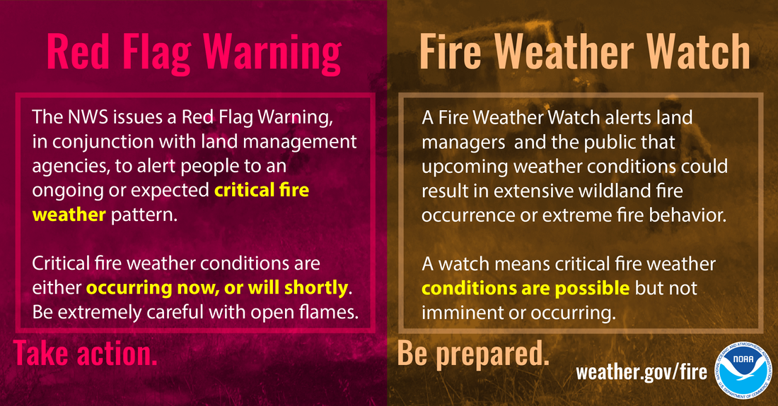
A “Fire Weather Alert” is a critical public safety notification issued by meteorological agencies when a combination of weather conditions creates an elevated risk for the ignition and rapid spread of wildfires. While the concept of understanding environmental risks for fire has existed for millennia, the precision, timeliness, and widespread dissemination of these alerts in the modern era are overwhelmingly powered by advanced technology. This isn’t merely a weather forecast; it’s a sophisticated interplay of cutting-edge sensors, complex algorithms, artificial intelligence, and digital communication networks designed to protect lives, property, and ecosystems. In the tech-driven world of today, understanding a fire weather alert means delving into the technological infrastructure that makes its prediction, communication, and response possible.
The Technological Backbone of Fire Weather Forecasting
The ability to accurately predict fire weather conditions has undergone a profound transformation, moving from rudimentary observations to highly sophisticated, data-intensive modeling. This evolution is entirely attributable to advancements in technology, which provide meteorologists and fire management agencies with an unprecedented view into atmospheric dynamics and ground conditions.
Sophisticated Sensor Networks and Satellite Monitoring
At the foundational level of fire weather forecasting are vast networks of environmental sensors. Ground-based weather stations, often equipped with IoT capabilities, continuously collect data on temperature, humidity, wind speed and direction, and fuel moisture content. These stations are strategically placed in fire-prone regions, sometimes even in remote wilderness areas, transmitting data wirelessly to central processing units. This localized, real-time data is crucial for understanding micro-climates and specific terrain influences that can dramatically alter fire behavior.
Complementing ground sensors are an array of satellite technologies. Geostationary and polar-orbiting satellites provide a macroscopic view, capturing imagery across various spectral bands. These images yield critical information such as vegetation health (which indicates fuel availability), land surface temperature, and the presence of smoke plumes. Advanced multispectral sensors can even detect heat signatures indicative of new ignitions, allowing for early detection of wildfires, a crucial factor in containment. The sheer volume and velocity of data streaming from these disparate sensor systems demand robust data pipelines and storage solutions, often residing in cloud-based infrastructures, allowing for scalable processing and accessibility.
AI and Machine Learning in Predictive Analytics
The colossal datasets generated by sensor networks and satellites would be overwhelming without the power of artificial intelligence (AI) and machine learning (ML). These technologies are rapidly becoming the “brains” of modern fire weather forecasting. ML algorithms are trained on decades of historical weather data, past fire incidents, and environmental parameters to identify intricate patterns and correlations that human analysts might miss.
For instance, supervised learning models can predict the probability of ignition and spread based on current and forecasted conditions, learning from instances where similar conditions led to significant wildfires. Neural networks are being deployed to process complex spatial and temporal data, improving the accuracy of humidity and wind forecasts, which are critical variables. AI models can also integrate data from various sources – including topographic maps, vegetation types, and human activity patterns – to create highly nuanced risk assessments. The continuous feedback loop, where model predictions are compared against actual outcomes, allows these AI systems to learn and adapt, progressively refining their accuracy over time. This AI-driven predictive analytics is what empowers agencies to issue alerts with higher confidence and earlier lead times.
High-Performance Computing for Atmospheric Modeling
Beneath the AI layer lies the raw computational power necessary to simulate complex atmospheric processes. High-Performance Computing (HPC) clusters run sophisticated Numerical Weather Prediction (NWP) models. These models divide the atmosphere into a three-dimensional grid and use complex mathematical equations to simulate the evolution of weather phenomena based on current conditions. For fire weather, these models are particularly tuned to simulate small-scale features like localized wind gusts, downdrafts, and inversions that significantly impact fire behavior.
The resolution of these models has increased dramatically with HPC advancements, allowing for more granular and accurate forecasts. Running these models requires immense processing power, often involving supercomputers that can perform trillions of calculations per second. The output of these HPC models provides the foundational atmospheric forecasts (temperature, wind, humidity, precipitation) that are then fed into fire behavior models, often enhanced by AI, to generate comprehensive fire weather predictions. The ability to run multiple model ensembles – slightly varying initial conditions to assess forecast uncertainty – is also a testament to this computational prowess, providing meteorologists with a more complete picture of potential outcomes.
Digital Communication Channels for Alert Dissemination
Once a fire weather alert is generated, its effectiveness hinges on rapid, widespread, and targeted dissemination. Modern technology has revolutionized how these critical warnings reach the public, moving beyond traditional media to embrace digital, mobile-first strategies.
Mobile Applications and Geo-fencing Technologies
In an increasingly mobile-centric world, dedicated weather and emergency alert applications have become primary channels for delivering fire weather warnings. Apps from national weather services, local emergency management, and even third-party developers integrate seamlessly with smartphone operating systems to deliver push notifications directly to users. These apps often leverage geo-fencing technology, which defines a virtual perimeter around a specific geographic area. When a user’s device enters or exits this geofenced area, or if an alert is issued for that area, a notification is triggered.
This precise geo-targeting ensures that only relevant alerts are sent to individuals in affected or nearby regions, reducing alert fatigue. Many apps also offer customizable settings, allowing users to opt-in for specific types of alerts, view interactive maps of affected areas, and access detailed preparedness information. The integration of GPS and location services in smartphones is fundamental to the efficacy of these targeted communication strategies, ensuring critical information reaches the right people at the right time.
Emergency Broadcast Systems and Wireless Emergency Alerts (WEA)
While apps offer personalized alerts, broader public warning systems remain crucial. Wireless Emergency Alerts (WEA) represent a cornerstone of this strategy in many countries, including the United States. WEA allows authorized government agencies to send geographically targeted, text-like messages to mobile phones within a specified area, even if users don’t have a specific app installed. These alerts bypass network congestion and often come with a unique, attention-grabbing tone, ensuring they cut through everyday digital noise.
Parallel to WEA, traditional Emergency Broadcast Systems (EBS) and their digital successors, like the Emergency Alert System (EAS), continue to transmit warnings over radio and television. These systems automatically interrupt programming to broadcast critical information, ensuring reach to populations who may not be using smartphones or who are consuming traditional media. The technological challenge here lies in integrating these disparate systems, ensuring consistent messaging across platforms, and maintaining the infrastructure’s resilience even during power outages or communication network disruptions.
IoT Devices and Smart Home Integration for Localized Warnings

An emerging frontier in alert dissemination is the integration with Internet of Things (IoT) devices and smart home ecosystems. Imagine a smart thermostat or a voice assistant that not only controls your home environment but also audibly announces a fire weather alert specific to your address. Smart smoke detectors could provide localized warnings or even integrate with home automation systems to shut off gas lines or close vents during a fire threat.
While still in nascent stages for fire weather alerts specifically, the underlying technology exists. Smart cities initiatives also explore how IoT sensors, public digital signage, and connected vehicles can be used to disseminate hyper-localized warnings and evacuation instructions. The promise of IoT is to make alerts ubiquitous and deeply integrated into daily life, providing multiple layers of notification beyond personal devices, though privacy and security considerations remain paramount for such widespread integration.
Tech-Driven Preparedness and Response Strategies
Technology doesn’t just predict and disseminate; it also plays a pivotal role in enabling effective preparedness and response when fire weather alerts become reality. From strategic planning to real-time incident management, digital tools are indispensable.
Geographic Information Systems (GIS) for Risk Mapping and Evacuation Planning
Geographic Information Systems (GIS) are foundational for fire management. These powerful mapping platforms integrate vast layers of spatial data – topography, vegetation types, land ownership, infrastructure (roads, power lines), demographics, and historical fire perimeters. When a fire weather alert is issued, GIS analysts can overlay current weather forecasts and fire behavior models onto these maps to create highly accurate risk assessments.
This allows emergency managers to identify specific communities or assets most vulnerable to fire spread. Critically, GIS is essential for developing and executing evacuation plans. It enables the visualization of safe routes, potential choke points, and alternative paths, helping to pre-plan evacuation zones and identify staging areas for emergency personnel. During an active incident, GIS provides real-time situational awareness, tracking fire progression, resource deployment, and damage assessments, all within a unified visual framework that aids rapid decision-making.
Drone Technology for Reconnaissance and Mitigation
Unmanned Aerial Vehicles (UAVs), commonly known as drones, have become invaluable assets in fire weather preparedness and response. Equipped with high-resolution cameras, thermal imaging sensors, and even LiDAR, drones can conduct rapid reconnaissance of large, inaccessible areas to identify potential fuel loads or detect new ignitions early. During an active fire, drones provide real-time intelligence to incident commanders, offering overhead views of fire perimeters, hot spots, and smoke patterns, which is critical for directing ground crews and aerial resources safely and effectively.
Beyond surveillance, specialized drones are being developed for mitigation efforts. Some can carry small payloads to conduct prescribed burns in controlled settings, while others are equipped to drop fire retardant or even perform targeted water drops. The ability of drones to operate in hazardous conditions without risking human pilots makes them a game-changer in both proactive land management and reactive firefighting strategies during fire weather events.
Data Visualization and Decision Support Tools for Emergency Services
Emergency services, from dispatch centers to incident command posts, rely heavily on sophisticated data visualization and decision support tools. These platforms aggregate real-time data from various sources – weather forecasts, GIS, drone feeds, 911 calls, social media monitoring, and resource tracking – and present it in intuitive, interactive dashboards.
These tools allow commanders to visualize the unfolding situation, assess resource availability (fire trucks, personnel, aircraft), manage logistics, and make informed decisions under immense pressure. For example, a dashboard might display predicted fire spread, overlaid with available fire engine locations and evacuation routes, enabling a commander to rapidly allocate resources or adjust evacuation orders. The objective is to provide a single, comprehensive operational picture, reducing cognitive load and accelerating response times during dynamic and high-stakes fire weather incidents.
The Future Landscape: Advancing Fire Weather Technology
The rapid pace of technological innovation promises even more advanced solutions for fire weather prediction, alert, and response. The future will likely see hyper-localization, greater autonomy, and enhanced resilience in the systems designed to combat the growing threat of wildfires.
Hyper-Local Forecasting and Micro-Climates
Future advancements will push forecasting beyond regional models to hyper-local predictions, down to individual neighborhoods or even specific valleys. This will involve dense networks of miniaturized IoT sensors, possibly integrated into urban infrastructure or natural environments, creating a “digital twin” of a landscape. AI models will be trained on these hyper-local datasets to predict micro-climatic effects like temperature inversions, wind channeling, and fuel moisture variations with unprecedented precision. This level of detail will allow for highly targeted alerts and pre-positioning of resources, mitigating risks at a much finer granularity.
AI-Powered Autonomous Mitigation Systems
Beyond mere prediction and response, the future may see AI-powered autonomous systems playing a more active role in mitigation. This could include AI-driven sensor arrays that automatically trigger localized, targeted mitigation actions. For example, in high-risk areas, a network of smart sprinkler systems could automatically activate based on real-time fire weather conditions, or autonomous drones could proactively identify and remove dry fuel loads in remote areas. Such systems would require advanced AI for decision-making, ensuring actions are precise, safe, and environmentally responsible, moving towards a more proactive and automated defense against wildfires.

Enhanced Digital Security for Critical Warning Infrastructure
As fire weather alert systems become more integrated and reliant on digital infrastructure, the need for robust cybersecurity will become paramount. Critical warning systems, sensor networks, and communication platforms could become targets for cyberattacks, potentially disrupting alerts or providing misinformation during a crisis. Future developments will undoubtedly focus on creating highly resilient, redundant, and secure systems, employing advanced encryption, blockchain for data integrity, and AI-driven threat detection to safeguard these vital public safety technologies. Ensuring the integrity and reliability of fire weather alerts in an increasingly connected world will be a continuous challenge and a crucial area of technological investment.
In conclusion, a fire weather alert is far more than a simple warning; it is the culmination of immense technological ingenuity. From the satellites orbiting Earth to the AI algorithms crunching petabytes of data, and from the mobile apps in our pockets to the sophisticated GIS systems guiding emergency responders, technology forms the invisible yet indispensable backbone of our collective defense against the devastating power of wildfires. As climate change continues to intensify fire seasons, the ongoing innovation in this tech domain will be absolutely critical for protecting communities and preserving natural landscapes.
aViewFromTheCave is a participant in the Amazon Services LLC Associates Program, an affiliate advertising program designed to provide a means for sites to earn advertising fees by advertising and linking to Amazon.com. Amazon, the Amazon logo, AmazonSupply, and the AmazonSupply logo are trademarks of Amazon.com, Inc. or its affiliates. As an Amazon Associate we earn affiliate commissions from qualifying purchases.