
In the digital age, we often take for granted the seamless transition of data from a virtual checkout screen to a physical doorstep. While the standard five-digit ZIP code is a household term, the additional four digits—formally known as the ZIP+4 code—represent a sophisticated layer of logistical technology. Introduced by the United States Postal Service (USPS) in 1983, these extra numbers are far more than mere administrative fluff. They are the backbone of a high-tech sorting infrastructure that utilizes optical character recognition (OCR), complex database management, and geospatial mapping to ensure that the global supply chain operates with surgical precision.
Understanding the “four numbers after the ZIP code” requires a deep dive into the intersection of data science, software engineering, and mechanical automation. For developers, logistics tech firms, and digital security experts, these digits are the key to unlocking “last-mile” efficiency and granular location intelligence.
The Architecture of the ZIP+4 System: A Data-Driven Breakdown
The original five-digit ZIP code system, established in 1963, was designed to facilitate the sorting of mail by geographical region. However, as the volume of mail increased and urban centers became more complex, the five-digit system lacked the granularity required for automated sorting. The introduction of the +4 extension transformed the ZIP code from a broad regional identifier into a precise geospatial pointer.
From Manual Sorting to Automated Optical Recognition
In the early days of postal services, mail was sorted manually by clerks who memorized routes. As volume scaled, this became a bottleneck. The transition to the ZIP+4 system coincided with the rise of advanced Optical Character Recognition (OCR) technology. Today, when a piece of mail enters a processing center, high-speed cameras capture the address. The software then queries a massive database—the National Change of Address (NCOA) and the City State File—to match the address to its unique +4 add-on. If the software can identify the specific +4 code, the mail can be automatically sorted down to the individual mail carrier’s bag in the exact order of their delivery route.
Anatomy of the Extra Four Digits: Sector and Segment
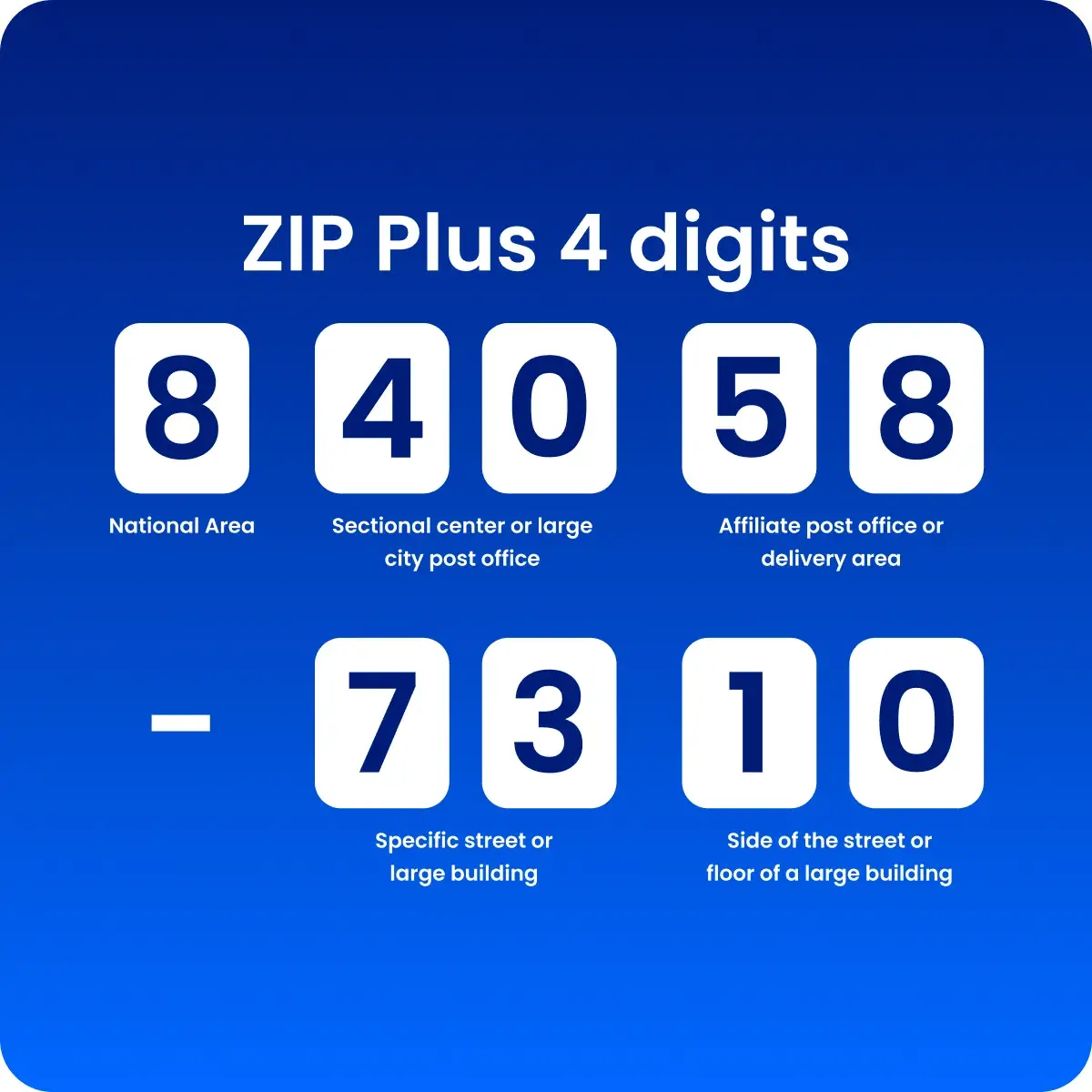
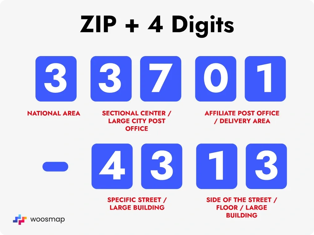
The four-digit add-on is divided into two distinct parts, each serving a specific hierarchical function in the data string:
-
The Sector (First two digits): These numbers identify a specific geographic area within the five-digit ZIP code. This could represent a group of city blocks, a large office complex, a small town’s specific neighborhood, or a large apartment building.
-
The Segment (Last two digits): This is the most granular level of the code. The segment identifies a specific side of a street, a particular floor in a high-rise building, a specific department within a large corporation, or even a specific group of post office boxes.
By categorizing locations into sectors and segments, the USPS database creates a digital map of the country that software can navigate without human intervention.
How Logistics Software and APIs Utilize ZIP+4 Data
For the modern tech stack, the ZIP+4 code is an essential data point for Address Verification Systems (AVS) and route optimization software. E-commerce giants and logistics startups rely on this data to minimize delivery failures and optimize the “last mile”—often the most expensive part of the shipping process.
Precision Geocoding for Delivery Optimization
Geocoding is the process of converting a physical address into geographic coordinates (latitude and longitude). While a five-digit ZIP code can cover a wide area, leading to “centroid” geocoding that might be miles away from the actual destination, the ZIP+4 code allows for “rooftop-level” accuracy. Logistics platforms integrate with APIs like Google Maps Platform, Smarty (formerly SmartyStreets), or the USPS Web Tools API to scrub and validate addresses.
When a system validates an address to the ZIP+4 level, it ensures that the destination actually exists in the USPS Master Address File (MAF). This reduces the “bounce rate” of physical packages, saving companies millions in fuel and labor costs. Furthermore, it allows routing algorithms to calculate the most efficient path for a delivery vehicle, accounting for one-way streets and specific building entrances that a broader ZIP code would miss.
Integration with E-commerce Platforms and CRM Systems
In the realm of software development, maintaining “clean” data is a constant challenge. When a user enters an address into a checkout form, background scripts (often running via AJAX or Fetch API) compare the input against a database of valid ZIP+4 codes.
-
Data Normalization: The software automatically formats the address to meet postal standards (e.g., changing “Street” to “ST” and adding the +4).
-
Reduced Friction: High-end UX design often utilizes ZIP+4 lookup to auto-fill city and state fields, reducing the number of keystrokes for the user and increasing conversion rates.
-
CRM Integrity: For enterprise-level CRM (Customer Relationship Management) systems like Salesforce or SAP, the ZIP+4 code is used to assign leads to specific sales territories with pinpoint accuracy, ensuring no overlap between regional representatives.
Digital Security and the Privacy Implications of Granular Location Data
As with any technology that increases precision, the ZIP+4 code brings both security benefits and privacy concerns. In the tech industry, the use of such specific geographic identifiers is a double-edged sword.
Preventing Fraud through Address Verification Systems (AVS)
From a digital security perspective, the ZIP+4 code is a vital tool in the fight against credit card fraud. When you make an online purchase, the payment gateway uses an Address Verification System (AVS). This system checks the billing address provided by the user against the address on file with the credit card issuer.
Because the ZIP+4 code is so specific, it serves as a robust “something you know” factor in multi-factor authentication scenarios. A fraudster might know your city and five-digit ZIP code, but they are less likely to know the specific +4 segment associated with your billing address. Tech-forward retailers use this discrepancy to trigger additional security checks or flag high-risk transactions for manual review.
The Trade-off Between Efficiency and Anonymity
On the flip side, the precision of the ZIP+4 code raises significant data privacy issues. In the era of Big Data, the ability to narrow down a person’s location to a “segment” (often just 10 to 20 households) makes it much easier to de-anonymize datasets.
Data brokers often combine ZIP+4 data with other digital footprints—such as IP addresses, browsing history, and purchase behavior—to create highly detailed consumer profiles. While a five-digit ZIP code is generally considered “de-identified” under certain privacy regulations (like HIPAA, depending on the population density), the ZIP+4 code is often treated as PII (Personally Identifiable Information) because it can pinpoint an individual’s residence with high probability. Software architects must therefore implement strict encryption and data retention policies when handling these extra four digits to remain compliant with GDPR or CCPA.
The Future of Micro-Location: Beyond the Four Digits
The ZIP+4 system was a 20th-century solution to a 20th-century problem, but it has laid the groundwork for the next generation of location-based technology. As we move toward autonomous delivery and the Internet of Things (IoT), the need for even more granular data is growing.
AI-Driven Route Optimization and Autonomous Logistics
We are currently seeing the integration of Artificial Intelligence (AI) with geospatial data. Machine learning models now ingest ZIP+4 data alongside real-time traffic patterns, weather conditions, and historical delivery times to predict the optimal window for a package to arrive.
For the burgeoning industry of autonomous delivery drones and sidewalk robots, the ZIP+4 code serves as an initial “geofence.” However, these technologies are already pushing for “Plus-8” or “Plus-10” precision—essentially digital coordinates that can guide a drone to a specific 3-foot by 3-foot landing pad on a customer’s balcony. The logic established by the ZIP+4 system—the idea of hierarchical, segmented location data—is the direct ancestor of these modern navigation meshes.

The Role of 5G and IoT in Real-Time Logistics
The rollout of 5G networks and the proliferation of IoT sensors are transforming how we interact with the ZIP+4 system. Smart mailboxes and connected delivery hubs can now broadcast their precise status back to the logistics cloud.
In this ecosystem, the ZIP+4 code acts as a static anchor for dynamic data. While the code tells the system where the destination is, IoT sensors tell the system what the status of that destination is (e.g., “mailbox full,” “secure gate open,” or “temperature-controlled locker available”). This synergy between a 40-year-old numbering system and cutting-edge hardware demonstrates the enduring power of well-structured data architecture.
In conclusion, those four numbers after your ZIP code are not just an optional add-on for the post office; they are a sophisticated digital tool. From the OCR algorithms that sort mail at lightning speed to the APIs that power global e-commerce and the security protocols that protect our financial data, the ZIP+4 system remains a cornerstone of the modern technological landscape. As we look toward a future of AI-driven logistics and hyper-local data, the “plus-four” continues to prove that in the world of technology, precision is the ultimate commodity.
aViewFromTheCave is a participant in the Amazon Services LLC Associates Program, an affiliate advertising program designed to provide a means for sites to earn advertising fees by advertising and linking to Amazon.com. Amazon, the Amazon logo, AmazonSupply, and the AmazonSupply logo are trademarks of Amazon.com, Inc. or its affiliates. As an Amazon Associate we earn affiliate commissions from qualifying purchases.