
The Earth is not a perfect sphere spinning upright in the vacuum of space. Instead, it orbits the sun at a lean—an angle of approximately 23.5 degrees relative to its orbital plane. While this phenomenon, known as obliquity, is a staple of middle-school science, the modern technological ecosystem required to measure, track, and simulate this tilt is among the most sophisticated in the world. From high-performance computing (HPC) and artificial intelligence to satellite laser ranging and quantum sensors, the “tilt” is no longer just a geographical fact; it is a massive data set that drives global positioning systems, climate modeling software, and agricultural technology.

In the digital age, understanding the tilt of the Earth’s axis is a feat of extreme engineering. It requires a synergy between hardware and software that spans the globe and extends into deep space. This article explores the cutting-edge technology used to monitor this celestial alignment and how that data is leveraged across various tech industries.
The Instruments of Accuracy: Hardware and Infrastructure for Measuring Obliquity
The Earth’s tilt is not static. Due to gravitational pulls from the moon and sun, as well as internal shifts in the Earth’s mass (like melting glaciers), the axis “wobbles” over time. Measuring these micro-adjustments requires hardware that operates with sub-millimeter precision.
Very Long Baseline Interferometry (VLBI)
The gold standard for measuring the Earth’s orientation in space is Very Long Baseline Interferometry (VLBI). This technology involves a global network of large radio telescopes that observe distant cosmic radio sources, such as quasars. By measuring the time difference between the arrival of a signal at different telescopes, scientists can calculate the Earth’s exact orientation, including its axial tilt, with incredible accuracy.
From a tech perspective, VLBI represents a triumph of data synchronization. The atomic clocks used at these stations must be synchronized to within billionths of a second. The resulting data streams are processed using massive correlators—specialized supercomputers—that filter out atmospheric noise to provide the baseline data used by every GPS-enabled device on the planet.
Satellite Laser Ranging (SLR) and GNSS
While VLBI looks outward at distant stars, Satellite Laser Ranging (SLR) looks inward. SLR stations fire high-powered laser pulses at retroreflectors on satellites orbiting the Earth. By timing the return trip of the photon, the exact distance to the satellite is determined.
This data, combined with Global Navigation Satellite Systems (GNSS) like GPS (USA), Galileo (EU), and GLONASS (Russia), allows tech platforms to account for “Polar Motion.” Software developers in the geospatial industry rely on these constant hardware updates to ensure that digital maps remain accurate. Without accounting for the slight shifts in axial tilt and rotation, a smartphone’s GPS would lose accuracy by several meters within a single day.
Digital Twins and Computational Models of Planetary Mechanics
Once the hardware collects the raw data regarding the Earth’s tilt, the focus shifts to the software. We are currently in the era of “Digital Twins,” where massive computational models of the Earth allow scientists and tech companies to simulate the effects of axial tilt on various global systems.
High-Performance Computing (HPC) in Geodesy
Geodesy—the science of measuring Earth’s shape and orientation—is a data-intensive field. Modern software suites used by organizations like NASA and the European Space Agency (ESA) run on supercomputing clusters to process “Milankovitch cycles.” These are long-term shifts in the Earth’s tilt and orbit that occur over thousands of years.
Software like GIPSY-OASIS (developed by JPL) and various open-source GNSS processing tools allow researchers to turn raw orbital data into actionable insights. These programs must handle petabytes of information, utilizing parallel processing to simulate how the tilt impacts everything from oceanic currents to atmospheric pressure zones.
AI-Driven Climate Simulations and Axial Fluctuations
Artificial Intelligence and Machine Learning (ML) are now being integrated into climate tech to predict how shifts in the Earth’s mass (such as groundwater depletion or ice sheet melt) will feedback into the axial tilt. Neural networks can identify patterns in decades of satellite imagery and gravimetric data that human analysts might miss.
For tech firms specializing in “Climate-as-a-Service” (CaaS), these AI models are vital. They allow companies to provide predictive analytics to insurers and governments regarding long-term weather patterns. Since the axial tilt is the primary driver of the seasons, any technological tool designed to predict long-term environmental change must have the Earth’s obliquity at the core of its algorithmic logic.
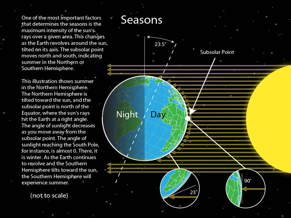
The Tech Behind the Seasons: Satellite Data and Global Infrastructure
The 23.5-degree tilt is the reason we have seasons. In the tech sector, this translates into a multi-billion dollar industry centered around remote sensing and seasonal data analytics.
Remote Sensing and Agricultural Optimization
Ag-Tech (Agricultural Technology) is perhaps the biggest consumer of tilt-related data. Modern “Precision Agriculture” platforms use satellite imagery (Remote Sensing) to monitor crop health. These satellites must be programmed with the precise knowledge of the Earth’s tilt to calculate the “Sun Angle” for any given day of the year.
Apps like Climate FieldView or John Deere’s Operations Center use this data to tell farmers exactly when to plant or harvest. The software calculates how the angle of the sun—dictated by the axial tilt—will affect photosynthesis rates and soil evaporation. This is a clear example of how a fundamental astronomical fact is converted into a digital tool for economic efficiency.
Renewable Energy Forecasting via Orbital Metrics
The solar energy industry is entirely dependent on the Earth’s tilt. Solar farm placement and the software that controls “trackers” (mechanisms that tilt solar panels to follow the sun) rely on astronomical algorithms. These algorithms calculate the solar zenith angle based on the Earth’s 23.5-degree lean.
Advanced IoT (Internet of Things) devices on solar farms use real-time data to adjust panel angles. This software ensures maximum photon capture, directly impacting the ROI of renewable energy tech. Without the precise digital mapping of the Earth’s axial tilt, the efficiency of global solar grids would plummet.
Emerging Tech: The Future of Earth Observation and Axial Tracking
As we look toward the future, the technology used to monitor and utilize the Earth’s tilt is moving toward miniaturization and quantum-level precision.
Quantum Sensors and the Next Generation of Geodetic Measurement
The next frontier in measuring the Earth’s movements lies in quantum technology. Quantum cold-atom interferometers are being developed to measure gravity and axial rotation with precision that far exceeds current mechanical gyroscopes or radio telescopes.
These quantum sensors, once miniaturized, could potentially be placed on small satellites (CubeSats). This would decentralize the measurement of Earth’s tilt, moving it from a few massive government installations to a distributed network of commercial sensors. This “democratization of geodetic data” would allow for even more precise software applications in autonomous driving and localized weather prediction.
The Role of Edge Computing in Real-Time Geospatial Analysis
As we deploy more sensors to track the Earth’s orientation and its environmental effects, the sheer volume of data is becoming a bottleneck. This is where “Edge Computing” comes in. Instead of sending all data back to a centralized cloud server, sensors on satellites or ground stations can process the data locally.
In the context of the Earth’s tilt, edge computing allows for real-time adjustments in satellite communication arrays. As the Earth moves and wobbles, satellites must constantly realign their transmitters. Edge-enabled software allows these adjustments to happen in milliseconds, ensuring that global digital security and communication links remain unbroken.

Conclusion: The Digital Axis
The 23.5-degree tilt of the Earth’s axis is more than a line in a textbook; it is a foundational constant for the modern technological world. From the VLBI telescopes that track our position relative to the stars to the AI models that predict our climatic future, the tech industry has built a massive infrastructure around this single astronomical fact.
As we move further into the decade, the integration of quantum sensors, AI, and high-performance computing will continue to refine our understanding of the Earth’s tilt. In a world where precision is the ultimate commodity, the technology used to track the “pivot” of our planet remains at the absolute cutting edge of human innovation. Whether you are using a GPS app to find a coffee shop or a scientist simulating the next century of climate change, you are interacting with a complex web of technology designed to answer one fundamental question: exactly how much is the Earth tilting today?
aViewFromTheCave is a participant in the Amazon Services LLC Associates Program, an affiliate advertising program designed to provide a means for sites to earn advertising fees by advertising and linking to Amazon.com. Amazon, the Amazon logo, AmazonSupply, and the AmazonSupply logo are trademarks of Amazon.com, Inc. or its affiliates. As an Amazon Associate we earn affiliate commissions from qualifying purchases.