
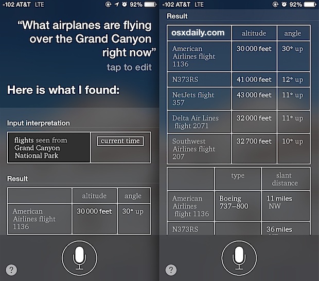
The impulse to look up at a passing aircraft and wonder about its destination, origin, and identity is a universal human experience. In the past, this curiosity remained largely unsatisfied, relegated to guesswork based on the color of a tail fin or the sound of the engines. Today, however, we live in an era of unprecedented transparency in the skies. Through a sophisticated interplay of transponder technology, global receiver networks, and consumer-grade software, the answer to the question “What is flying over me right now?” is available at our fingertips.
The technology behind real-time flight tracking has transitioned from the exclusive domain of Air Traffic Control (ATC) centers to a democratized digital ecosystem. By leveraging various data streams—primarily ADS-B, MLAT, and satellite data—anyone with a smartphone or a computer can access a live, high-fidelity map of the global airspace.

The Evolution of Real-Time Flight Tracking Technology
To understand how we can identify a plane at 35,000 feet, we must first look at the hardware and software protocols that make modern aviation visible. For decades, radar was the primary tool for tracking aircraft. Primary radar works by bouncing radio waves off an object to determine its position. While effective for security, it provides limited information about the specific aircraft.
ADS-B: The Core of Modern Aviation Tracking
The revolution in modern tracking is driven by Automatic Dependent Surveillance-Broadcast (ADS-B) technology. Unlike traditional radar, ADS-B is “automatic” because it requires no pilot or operator intervention. It is “dependent” because it relies on data from the aircraft’s navigation system.
An ADS-B-equipped aircraft uses GPS to determine its precise position and then broadcasts that information, along with its altitude, airspeed, and a unique identification code, via a transponder. This signal is transmitted on the 1090 MHz frequency. Because these signals are unencrypted and broadcast into the open air, they can be intercepted by anyone with a relatively inexpensive software-defined radio (SDR) receiver.
How Ground Stations and Satellites Work Together
The visibility of the skies depends on a vast, crowdsourced network of ground stations. Enthusiasts around the world host small receivers (often built using Raspberry Pi computers) that capture ADS-B signals and upload the data to central servers. When you open a flight tracking app, you are looking at the aggregated data from tens of thousands of these individual nodes.
In areas where ground stations are unavailable—such as the middle of the Atlantic Ocean or over the poles—space-based ADS-B comes into play. Companies like Aireon have placed ADS-B receivers on satellites, ensuring that aircraft can be tracked even when they are thousands of miles from the nearest terrestrial receiver. This technological leap has virtually eliminated “black holes” in global flight monitoring.
Essential Apps and Tools for Identifying Aircraft
For the average user, the complex data processed by ADS-B receivers is translated into intuitive, graphical interfaces. Several key players dominate the market, each offering different layers of technical depth and utility.
Flightradar24: The Industry Leader
Flightradar24 is perhaps the most well-known tool for identifying aircraft. Its success lies in its massive network of over 30,000 ground receivers and its polished user experience. The app’s “AR View” (Augmented Reality) is particularly relevant to the question of what is flying overhead. By pointing a phone’s camera at the sky, the software overlays digital information—including the flight number, aircraft type, and airline—directly onto the visual image of the plane.
Behind the scenes, the app uses your device’s GPS and magnetometer to align your field of view with its database of real-time flight positions. It is a masterclass in applying consumer-grade sensor technology to solve a complex data visualization problem.
ADS-B Exchange: Unfiltered Data Access
While mainstream apps often filter out certain aircraft for privacy reasons (such as private jets owned by high-profile individuals or certain government planes), ADS-B Exchange prides itself on being “the world’s largest source of unfiltered flight data.”
From a technical perspective, ADS-B Exchange is a favorite among researchers and journalists. It does not honor “block list” requests, meaning it provides a more complete picture of the airspace. If you see a plane overhead that doesn’t appear on standard apps, it is likely visible here. The platform demonstrates the power of open-source intelligence (OSINT) and the challenges of maintaining privacy in a world where radio broadcasts are public by default.
PlaneFinder and Specialized Alternatives
Other tools like PlaneFinder and RadarBox offer unique features, such as 3D playback and detailed historical data. These platforms often provide deeper technical specifications of the airframe, including the “hex code” (a unique 24-bit address assigned to every aircraft) and the specific age of the plane. This allows tech-savvy users to track the history of a single airframe as it moves across different owners and liveries over decades.
Beyond Commercial Planes: Identifying Drones and Military Aircraft
The question of “what is flying over me” is no longer limited to commercial airliners. The sky is increasingly occupied by unmanned aerial vehicles (UAVs) and military assets, which operate under different technical protocols.

Remote ID and the Future of Drone Tracking
As drones become ubiquitous for delivery, photography, and industrial inspection, the need for “digital license plates” has become a regulatory priority. The FAA’s Remote ID protocol is the tech industry’s answer to this.
Remote ID acts like a “digital beacon” for drones. Much like ADS-B for planes, Remote ID requires drones to broadcast identification and location information via Wi-Fi or Bluetooth. New software tools are currently being developed that allow anyone with a standard smartphone to “sniff” these broadcasts and identify a drone hovering nearby. This represents a significant shift in personal security and privacy tech, moving tracking capabilities from the stratosphere down to the neighborhood level.
MLAT and Tracking the “Invisible”
Not all aircraft broadcast ADS-B data. Older planes or certain military aircraft may only use older Mode S transponders, which do not broadcast GPS coordinates. To track these, software platforms use Multilateration (MLAT).
MLAT is a sophisticated mathematical process that calculates an aircraft’s position based on the “Time Difference of Arrival” (TDOA) of its signal at multiple ground stations. By measuring the nanosecond differences in when a signal reaches four or more different receivers, the software can triangulate the aircraft’s location. This allows users to “see” aircraft that are technically trying to stay off the grid, showcasing the ingenuity of decentralized data processing.
Looking Up: Tracking Satellites and the International Space Station
Sometimes, what is flying over you isn’t an aircraft at all, but an object in Low Earth Orbit (LEO). With the launch of massive satellite constellations like SpaceX’s Starlink, the night sky is busier than ever.
AR Overlays and Visual Recognition Apps
Apps like SkyView, Night Sky, and Heavens-Above specialize in orbital mechanics rather than aerodynamics. These tools use TLE (Two-Line Element) sets—a data format used by NORAD to track space objects—to predict exactly when a satellite will pass over your specific coordinates.
The technical challenge here is different from flight tracking. While planes broadcast their own location, satellites are generally passive observers from a consumer perspective. Identification relies on highly accurate orbital modeling. When a “train” of Starlink satellites passes overhead shortly after launch, these apps use real-time orbital data to help users distinguish between a line of satellites and other celestial phenomena.
The International Space Station (ISS)
The ISS is perhaps the most sought-after object for “over-me” tracking. Moving at roughly 17,500 miles per hour, it crosses the sky in mere minutes. Tech tools like “ISS Detector” use your phone’s location data to provide “pass alerts.” These notifications are calculated by cross-referencing your position with the ISS’s current state vector, accounting for the Earth’s rotation and the station’s orbital decay.
The Future of Airspace Awareness and Personal Tech
The technology used to identify objects in the sky is rapidly converging with Artificial Intelligence and the Internet of Things (IoT). We are moving toward a future where “airspace awareness” is an ambient feature of our digital lives.
Integration with Smart Devices and AI
Imagine a smart home system that automatically dims its outdoor lights and provides a notification when a rare vintage aircraft or a high-profile flight is passing overhead. Developers are already using APIs (Application Programming Interfaces) from services like the OpenSky Network to build custom integrations. By feeding real-time flight data into AI models, these systems can learn to identify patterns—such as a flight that is circling or off-course—and alert users to potential emergencies before they hit the news.
Furthermore, computer vision is being integrated into tracking software. New experimental apps are attempting to identify planes simply by analyzing a photo of the silhouette against the sky, using machine learning models trained on thousands of aircraft shapes. This would provide a secondary layer of identification for aircraft that have their transponders turned off.
Privacy vs. Transparency in Digital Skies
As tracking technology becomes more accessible, it triggers a complex debate regarding digital privacy. High-net-worth individuals and corporations often argue that real-time tracking poses a security risk. This has led to the development of programs like PIA (Privacy ICAO Address), which allows aircraft owners to use a rotating, anonymous identification code.
However, the tech community often responds with “signal-agnostic” tracking. Because the radio waves are physical reality, and the math of triangulation is constant, total invisibility in the modern age is nearly impossible. The tension between the “right to track” and the “right to fly privately” will continue to drive innovation in both encryption and detection software.
Conclusion
The next time you hear a rumble in the clouds and ask “What is flying over me right now?”, you are tapping into a massive, global digital infrastructure. From the 1090 MHz radio bursts emitted by an Airbus A350 to the orbital calculations keeping track of the ISS, the technology of identification is a testament to the power of connected data. Whether through AR overlays on a smartphone or filtered data streams on a high-end workstation, the transparency of our skies is a defining characteristic of the modern technological landscape. We no longer just watch the birds; we monitor the entire machine.
aViewFromTheCave is a participant in the Amazon Services LLC Associates Program, an affiliate advertising program designed to provide a means for sites to earn advertising fees by advertising and linking to Amazon.com. Amazon, the Amazon logo, AmazonSupply, and the AmazonSupply logo are trademarks of Amazon.com, Inc. or its affiliates. As an Amazon Associate we earn affiliate commissions from qualifying purchases.