
In the landscape of modern logistics and data management, the five-digit ZIP code is a ubiquitous element of American infrastructure. However, for those looking at the technical architecture of the United States Postal Service (USPS) and the software systems that power global commerce, the true power lies in the often-overlooked four digits that follow: the ZIP+4 code. Introduced in 1983, this extension represented a massive leap forward in automated mail processing, digital indexing, and geographic information systems (GIS).
Understanding the technical nuances of these four digits is essential for developers, data scientists, and logistics engineers. It is not merely a “more specific” address; it is a complex data point that enables high-speed sorting algorithms, precise geolocation, and the seamless integration of physical delivery routes into digital databases.
The Technical Anatomy of the ZIP+4 System
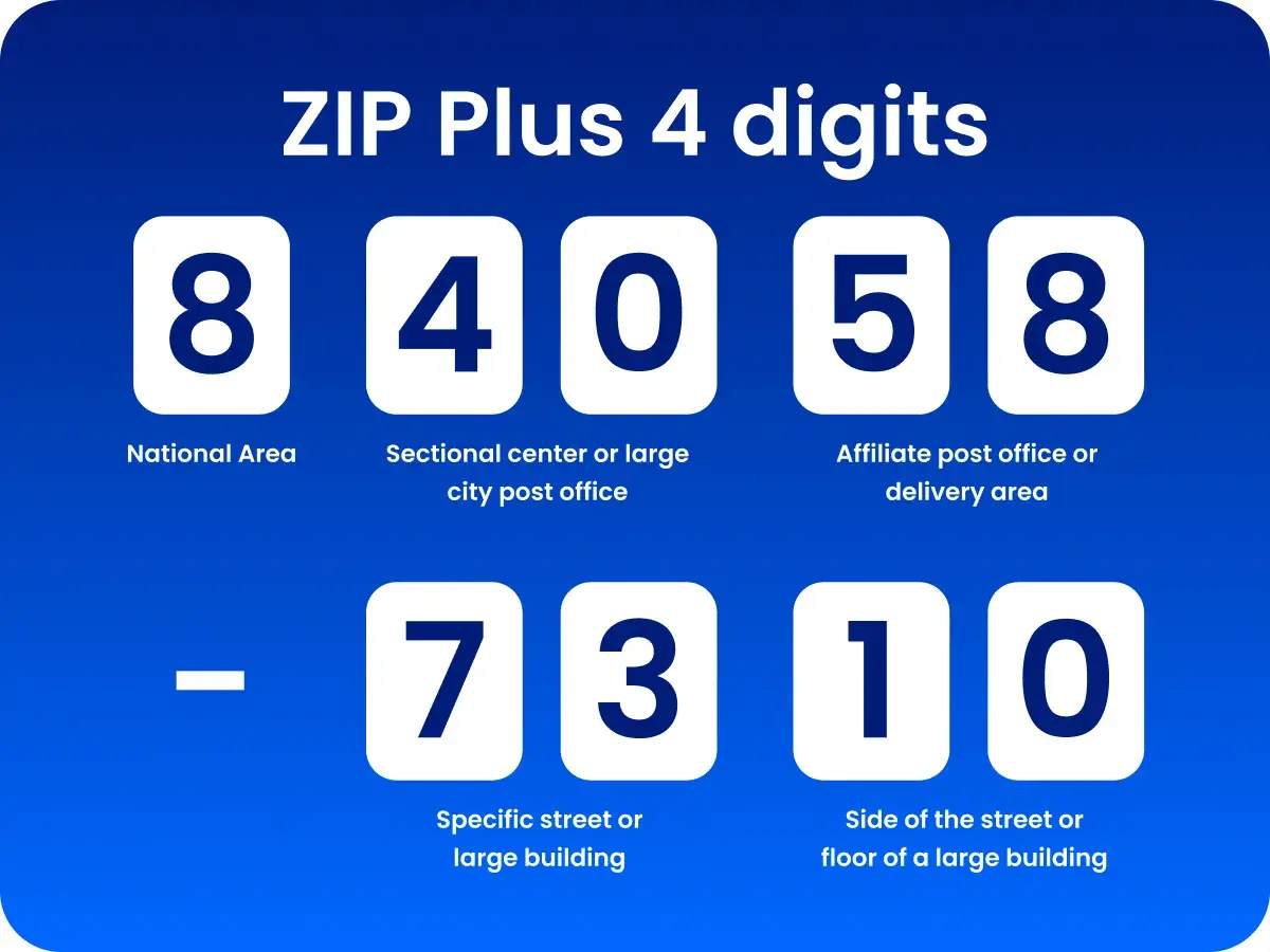
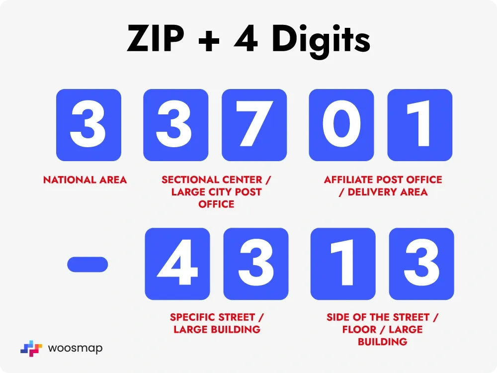
The original five-digit ZIP code, established in 1963, was designed for a world where humans manually sorted mail into bins. The first digit represents a broad geographic area (e.g., “0” for the Northeast, “9” for the West), while the next two digits represent a sectional center facility (SCF), and the final two digits represent a specific post office or delivery area.
As mail volume surged and computer technology advanced, the USPS required a more granular method to facilitate machine-led sorting. This led to the creation of the ZIP+4 code, which breaks down the delivery area into much smaller, manageable technical segments.
The Delivery Sector (Digits Six and Seven)
The first two digits of the +4 extension—the sixth and seventh digits of the full code—designate a “delivery sector.” In a technical sense, this identifies a specific geographic area within a five-digit ZIP code. This might represent a cluster of city blocks, a large office complex, or a specific neighborhood subdivision. For software engineers building routing algorithms, the delivery sector serves as the primary filter to group packages into larger regional batches before they reach the final distribution point.
The Delivery Segment (Digits Eight and Nine)
The final two digits of the +4 extension are the “delivery segments.” This is the most granular level of the USPS sorting hierarchy. A segment can represent a specific side of a street, a single floor in a high-rise building, a specific department within a large corporation, or even a group of post office boxes.
From a data architecture perspective, the delivery segment allows for “point-to-point” logic. When a mail-sorting machine reads these last two digits, it is identifying the exact shelf or “bin” on the delivery truck where that item belongs. This level of precision minimizes the cognitive load on human carriers and allows for the automation of the “last mile” of logistics.
Algorithms and Automation: How Machines Process the +4
The implementation of the ZIP+4 code was the catalyst for the development of advanced Optical Character Recognition (OCR) and barcode technology. Without these four digits, the high-speed sorting machines used in modern distribution centers would be significantly less efficient.
Optical Character Recognition (OCR)
When an envelope enters a processing center, it is scanned by a high-resolution camera. The system’s OCR software identifies the address block, parses the text, and attempts to match it against a national database known as the City State Product. If the software can match the street address and city to a specific +4 extension, it “perfects” the address.
The technical challenge here involves managing massive datasets in real-time. The OCR system must account for variations in handwriting, font types, and physical distortions of the paper, all while querying a database that contains millions of unique +4 records.
The Intelligent Mail Barcode (IMb)
Once the ZIP+4 code is identified, the sorting machine prints an Intelligent Mail barcode (IMb) on the mailpiece. The IMb is a 65-bar symbol that encodes the tracking information, service type, and, most importantly, the routing information. The routing information in an IMb typically includes the ZIP+4 code and a two-digit “delivery point code,” resulting in an 11-digit string that identifies a unique mailbox.
This barcode allows the mail to be sorted by Wide Area Bar Code Sorters (WABCS) at speeds exceeding 30,000 pieces per hour. The transition from five to nine (or eleven) digits essentially moved the logic of mail delivery from the human brain to the machine’s processor.
Integrating ZIP+4 into Software Development and Data Science
For developers building e-commerce platforms, CRM systems, or fintech applications, the ZIP+4 code is more than a postal requirement; it is a tool for data validation and spatial analysis.
CASS Certification and Address Standardization
Software that handles physical addresses often undergoes CASS (Coding Accuracy Support System) certification. CASS is a process designed by the USPS to improve the accuracy of five-digit ZIP and ZIP+4 codes. When a user enters an address into a web form, a CASS-certified API will communicate with the USPS database to standardize the address (e.g., changing “Street” to “ST”) and append the correct +4 code.
This is technically significant for several reasons:
- Data De-duplication: By standardizing addresses to their ZIP+4 format, databases can more easily identify duplicate records that might have different spelling variations.
- Reduced Latency: Accurate +4 codes allow for faster processing in fulfillment centers, which is critical for the “real-time” expectations of modern software-driven commerce.
- Cost Efficiency: For bulk mailers, the use of ZIP+4 is often a prerequisite for discounted postage rates, as it offloads the sorting work from the postal service to the sender’s software.
GIS and Geolocation Precision
In the world of Geographic Information Systems (GIS), a five-digit ZIP code is often too broad for accurate spatial analysis. A single ZIP code can span dozens of square miles and encompass diverse demographics. The ZIP+4 code provides a much higher “spatial resolution.”
Data scientists use these extensions to perform hyper-local analysis. For example, in real estate tech, the +4 extension can help isolate property value trends on one side of a street versus the other. In telecommunications, it helps engineers map out fiber-optic layouts by identifying high-density delivery segments within a single city block.
Security, Fraud Prevention, and the Digital Supply Chain
As digital security becomes increasingly intertwined with physical logistics, the ZIP+4 code has evolved into a layer of the “verification stack.”
Address Verification Service (AVS)
In fintech and e-commerce, AVS is a tool used by processors to detect fraudulent credit card transactions. When a transaction is processed, the system compares the billing address provided by the user with the address on file at the issuing bank. Including the ZIP+4 code adds an extra layer of granularity to this check. While a fraudster might know a victim’s five-digit ZIP code, they are less likely to know the specific +4 extension, especially for businesses or apartment complexes with specialized routing.
Supply Chain Integrity
The precision of the +4 code is vital for the “Cold Chain” and high-value hardware shipping. When a package contains sensitive technology or temperature-controlled pharmaceuticals, every minute spent on a delivery truck matters. Software that utilizes ZIP+4 can optimize delivery routes to ensure that these high-priority segments are reached first, using predictive modeling to minimize transit time based on the specific delivery segment’s historical traffic and access data.
The Future: Smart Cities and Hyper-Local Logistics
Looking forward, the architecture of the ZIP+4 system is being integrated into the development of “Smart Cities” and autonomous delivery systems. As we move toward a future of drone delivery and autonomous ground vehicles (AGVs), the need for hyper-precise geographic identifiers will only grow.
Drones and the +4 Coordinate System
An autonomous drone cannot simply be told to “go to 90210.” It requires a specific three-dimensional coordinate. The ZIP+4 system provides a bridge between traditional human-readable addresses and the machine-readable coordinate systems used by flight controllers. By mapping +4 segments to specific GPS coordinates, developers can create “drop zones” that are far more accurate than a standard street address would allow.

The Evolution of the Database
The USPS continues to update the ZIP+4 database every month, reflecting the constant construction of new buildings and the shifting of city boundaries. For the tech industry, this means that the +4 code is not a static piece of information, but a dynamic data stream. The rise of APIs that provide real-time access to these updates ensures that the digital twin of our physical world remains accurate.
In conclusion, the four numbers following the ZIP code represent one of the most successful implementations of a legacy system evolving into a modern technical asset. By breaking down geographic areas into sectors and segments, the ZIP+4 code provides the granular data necessary for high-speed automation, sophisticated software validation, and the next generation of autonomous logistics. It is the silent engine of the delivery economy, proving that in the world of technology, precision is the ultimate commodity.
aViewFromTheCave is a participant in the Amazon Services LLC Associates Program, an affiliate advertising program designed to provide a means for sites to earn advertising fees by advertising and linking to Amazon.com. Amazon, the Amazon logo, AmazonSupply, and the AmazonSupply logo are trademarks of Amazon.com, Inc. or its affiliates. As an Amazon Associate we earn affiliate commissions from qualifying purchases.